|
Connection to the Earth Science
Curriculum
Essential
Lessons:
Human impact on an ecosystem can take
weeks, months or even years to become evident. But, in some cases,
a catastrophic event can cause an immediate and devastating
impact. Can this human caused
catastrophic event be reversed or even improve the ecosystem of the
Kalamazoo River?
Earth Science Literacy Principles-
1. Big Idea 9:
Humans significantly alter the Earth.
2. Big Idea 3: The
Earth is a complex system of interacting rock, water, air and
life.
Common misconceptions
1. The
Earth can absorb and neutralize any amount of waste and pollution
over time.
2. Technological
fixes will save us from ruining our planetary
environment.
3. Dilution is still
the solution to pollution.
Michigan State Science Content Expectations
Addressed:
E2.4B Explain how the impact
of human activities on the environment, can be understood through
the analysis of interactions between the four Earth
systems.
E2.4A Describe renewable and non renewable
sources of energy for human consumption (electricity, fuels)
compare their effects on the environment, and include overall costs
and benefits.
E4.1C Explain how water quality in both
groundwater and surface systems is impacted by land use
decisions.
Vocabulary
Bitmous Oil – A form of
sandstone saturated with heavy oil.
Also called Tar sands.
API gravity index – America
Petroleum Institute – index rating for oil
density
Pleistocene
Glacial epoch – from 2.5 million to 11,700 years
ago. Also
known as the last Ice Age.
Permeable – having openings or
holes for the ability to flow through something
Macro
invertebrate – small organisms able to be seen with naked
eye. Ie. Mayfly larvae, dragonfly larvae,
etc.
PCB – Polychlorinated bephenyl
– a class of organic compounds from
manufacturing
Point Bar – an area where material is
deposited
Cutting Bank Erosion – an area
where material is eroded.
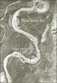
Figure 2. Cut bank erosion and point bar deposition as
seen on the Powder River in Montana.
http://www.wikipedia.org/cut/bank
|
Kalamazoo River Oil Spill
EarthCache
Battle
Creek to Kalamazoo,
MI
Note: This is a multistop EarthCahce. All 3 points are easily
accessible, but for the 3rd point, the best visibility
is on the bridge sidewalk of a
busy road, so watch for cars!
Kalamazoo
Oil Spill Background
Information:
The July 26, 2010 Enbridge 6B Pipeline break and resulting oil
spill occurred in Talmadge Creek, a cold water stream, (just
outside Marshall, MI), which is a tributary of the Kalamazoo River
a high quality warm water stream, which is part of the Lake
Michigan Watershed.1
(Michigan.gov/documents)
Approximately 819,000 gallons
of Bitmous* (a viscous, hydrocarbon mixture) oil was released
before the pipeline break was contained. The oil spread affected approximately 30 miles of
the Talmadge Creek, to the west end of Morrow Lake. The oil spread was contained on July 28, 2010
before it was able to mix with PCP residue at the bottom of the
Kalamazoo River due to industrial waste near Kalamazoo,
MI. The oil (also known as tar sand),
had a viscosity of 11 API, which is slightly less dense than water
and therefore, sinks rather than floats on
water.2
Due to a large amount of rainfall (about 5 inches) in
the area several days prior to the oil spill, the river was at an
elevated (flood) level and fast flowing. The oil also evolved (weathered), where the more
dangerous chemicals bonded with other chemical in the water
(reducing oxygen levels for wildlife and coating them with a black
gunk), or evaporated in the air (causing the smell)3
The spill has led to the evacuation of homes
(of which Enbridge has bought 230 homes or properties), drinking
water, swimming and fish consumption
advisories.4
By summer of 2011, over 3,100 species of
wildlife, bird, turtles, frogs, & mammals, have been caught,
cleaned and released or are continuing care. 5
Even though the Enbridge Oil spill occurred
in Marshall, MI, there are several areas from Battle Creek to
Kalamazoo that are still affected and are in the process of
cleanup. The main spill area is still
closed off to the public, but these areas on this EarthCache will
show where there are still pockets of submerged oil, and give you a
good idea of what is involved with the cleanup / restoration
effort.

Figure 1.Sumberged Oil Figure, "EPA
Response to Enbridge Spill in Michigan",
epa.gov/enbridgespill
Hydrology
The Kalamazoo
River is influenced by Pleistocene glacial deposits that cover most
of the watershed. The soils are
moderately fine to moderately coarse texture with permeable
soil. The water quality is still
considered good based on macroinvertebrate studies, despite the PCP
contamination. 6
Michigan.gov/documents
Materials
needed: This information, a
hand held GPS, ruler, binoculars (optional), a map of Battle Creek
and Kalamazoo. (this helps as a handheld
GPS doesn’t take roads into account!) Make sure you know how to use your GPS, and enter
the coordinates correctly
Tour of Kalamazoo
River
Stop 1: N 42o17.493’ W
085o33.752’
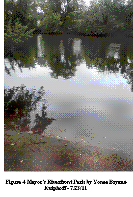
Mayors Riverfront
Park: This is a Minor
League/ picnic/public park along the Kalamazoo River on the
Southeast side of Kalamazoo, MI. There
are many trees and walkways, a play area and abundant
vegetation.
This area has
not been impacted by the oil spill.
However, as you look around at this point you see evidence of
natural erosion from the tree roots exposed at the large tree to
your left, to the Observation deck that is closed. If you look closely, you also see the recent flood
lines from the heavy rains. Take
notes of the natural erosion and the appearance of the banks of the
river and its makeup. This will be your
basis for comparison.
Logging Q1: What is the
size of the sediment/soil/rocks at this area? Does the river curve so that erosion is
impacted at this point? (point bank for
collecting or a cut bar for erosion?)
Logging
Q2: What kind of animal life is
present? (You may have to use your binoculars to check along the
banks – be very quiet) Note:
Wildlife does include snails, waterbugs, etc., as these organisms
are eaten by the larger consumers.
|
|
|
 |
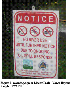
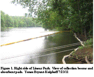
Stop 2:
Battle CreekLinear Park :
N 42o20.624’ W
085o14.535’
There was a black barrier a few yards beyond the Road end
sign. It has been removed as the ground
on shore has been cleared. The barrier
was there to designate the cleaned / restored area. Take note of the sign to the left that advises
against boating, fishing, swimming and other water use due to the
spill. Was there a sign at Mayors
Riverfront Park?
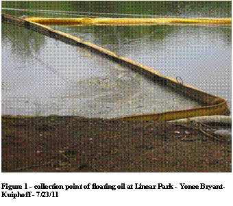
There are yellow float booms in the river
channeling floating oil to a point and white absorbent pads lining
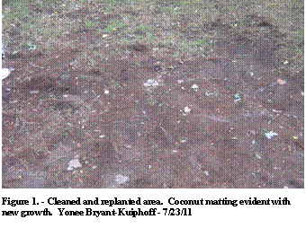
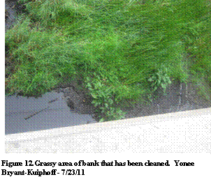
the banks. There is evidence of new
growth along the banks as a result of cleaning of rocks, tree bark,
and soil replacement and reseeding with coconut
matting. Locally hired workers did the
cleaning with Dawn dishwashing detergent and scrub
brushes. There is scum/light sheen of
oil collected in the corner of the yellow booms. As of Oct 8, 2011, The white absorbent pads have been
removed, and straw added to protect the new
growth.
Logging
Q3: Compare the untouched
area you saw at Riverfront Park and this area at Linear Park. There
has been substantial restorative effort here. The area with the
island has been dredged and sediment removed or soil replaced as
well as the area that you are standing on. Is this area a point bank
(collecting) or a cut bar (erosion)?
Logging
Q4: What is the size of the
soil / rocks at this area? How do you
think the size of the rocks and soil will impact erosion at this
point?
Logging
Q5: Is there any evidence of
wildlife? (again, use your binoculars and be very
quiet)
Stop 3: Bridge at Historic Bridge Park (busy
road) N 42o17.407’ W
085o07.002’
(If the park is still
closed – you may go over the bridge to the first street park
there.)
There is still evidence of ongoing clean up
– tanker collecting truck, dredging equipment,
airboats. There is still evidence of
oil sheen, sometimes in football size pockets floating by. There is
evidence of grass brushing (cleaning) and tree removal and soil
dredging / removal as you travel back and forth from one side to
another.
As of Oct 8, 2011, the dredging equipment has
been removed, but evidence is still there..
Logging
Q6: Compare this area to Linear
Park (stop #2). You notice that parts
of the River bank have been stripped away to be cleaned or
replaced. Should Enbridge install
artificial point banks (collection points) using the natural flow of the river to use for
future oil collecting and testing sites for the sunken
oil?
Logging
Q7: What is the size of the
soil and rocks at this point? How will this size impact
erosion?
Logging Q8: Is there any
evidence of wildlife (again, you may have to use your binoculars
and be very quiet)
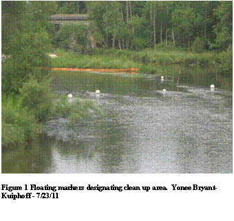
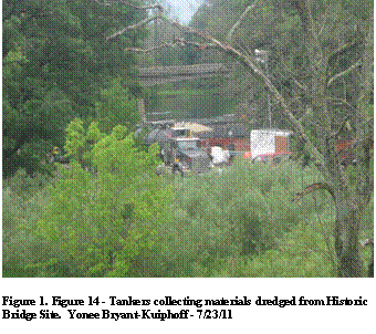
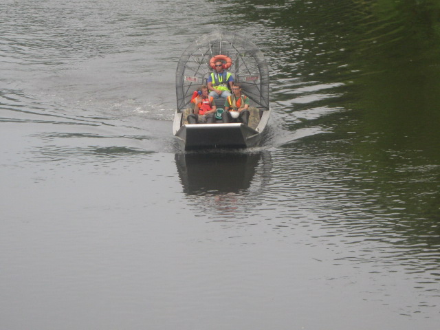
Figure 11.
Workers mode of transportation - Historic Bridge Site. Yonee Bryant-Kuiphoff - 7/23/11
Cleanup by the
Numbers: 766,000 gallons of oil
recovered
15.1 million gallons of oil/water collected and
disposed
113,000 cubic yards soil/debris
disposed
48 Boom locations
38,975 ft of boom deployed on
river
$29.1 million cost to date
(EPA’s Response to the Enbridge Oil Spill – July 11,
2011)
References:
Author uncited (11/1/2010) Daily Wildlife
Reports.
www.fws.gov/midwest/oilspill/wildlifereports.html
Retrieved July
28, 2011.
Author uncited (updated 7/11/11) EPA’s Response to The
Enbridge Oil
Spill. www.EPA.gov/enbridgespill/
Retrieved July 28, 2011.
Author uncited (July 8, 2011) 5.0 Kalamazoo River – Conceptual
Site
Model.
http://www.michigan.gov/documents/deq/wrd-enbridge-
csm-II_358533_7.pdf
Retrieved July 29, 2011
Klug, Fritz (2011, July 23)
Kalamazoo River Oil Responders
‘Writing
The Book’ on Submerged Oil Clean Up (with
videos).
Retrieved
from:
http://www.mlive.com/news/kalamazoo/index.ssf/2011/07/Kalamazoo_River_oil_spill_resp.html
Schaetzl, Randall J., Darden Joe
T. and Brandt, Danita S.
(2009)
MichiganGeography and Geology. New York: Custom
Print.
|