The McArthur Island Treasure Hunt (MITH) series is a geo-training playground for new geocachers with a variety of cache types and difficulty levels. Caches are safe, family-friendly, and some are wheelchair accessible. All caches promote the highest standards of geocaching etiquette by encouraging cachers to practice low impact caching, respect other park users, and trade responsibly.
Most of all, they are meant to be fun!
The above coordinates bring you to a lovely spot on McArthur Island overlooking the Thompson River and Rabbit Island.

Rabbit Island - November 2011
What is a freshet?
The term freshet refers to a flood or high water runoff resulting from a spring thaw occurring in rivers in the northern part of North America, particularly Canada. Spring thaws in the Kamloops area usually occur between the months of May and July when the snowpack in the mountains melts and causes rivers and creeks to rise. When the snowpack is particularly heavy, a sudden warm spell can increase the rate of melting, causing more water than normal to enter the river systems. Although a freshet can also refer to a flood caused by heavy rain, these are usually flash floods. Flooding from a spring thaw is slow and progressive.
Kamloops Flooding History:
Much of Kamloops is built on the floodplain of the Thompson rivers. In 1894, a significant flood occurred in the valley damaging many homes. The damage would have been worse but the area was sparsely populated at the time. Since then, dykes, or ridges of earth and rock, have been constructed to protect local property from rising waters. In 1972, a major flood broke through the dykes that protected the Oak Hills subdivision, causing extensive damage in the trailer park. The large stone monument in Riverside Park by the Rivers Trail shows the river levels during several of these momentous floods. The 1972 flood disaster on the North Thompson and other British Columbia rivers motivated the Provincial government to map the flood plains of many rivers throughout the province. As a result, a number of major dykes were built to protect lands from large floods. The Oak Hills subdivision in northern Kamloops lies behind one such major dyke.
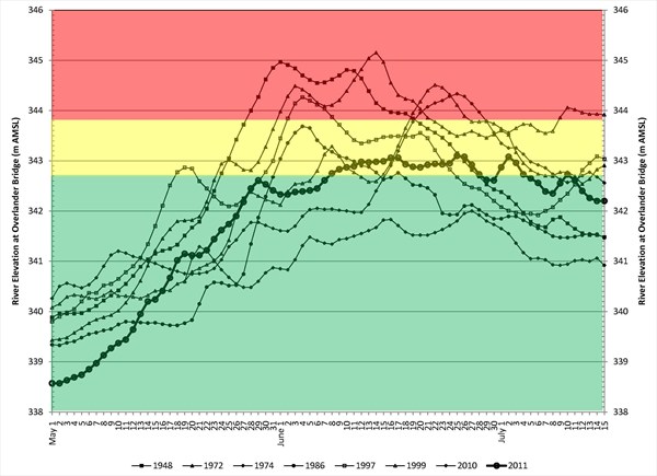
Figure 1. River elevations by year (courtesy of the City of Kamloops)
Figure 2. 20 year flood plain for North Kamloops (courtesy of the City of Kamloops)
Figure 3. 200 year flood plain for North Kamloops (courtesy of the City of Kamloops)
The Flood of 1948:
According to an article in the Kamloops News, June 29, 1984, written by John Stewart of the Kamloops Museum, the Thompson River rose 2 inches every hour by May 26, 1948. North Kamloops was the area officials were most concerned with, and 500 men with equipment rapidly built dykes around lower lying areas. This prevented massive flooding in the area but McArthur Island, where you are standing, and areas along Mackenzie and Royal Avenues were underwater.
Ingredients for a flood:
Flooding on major rivers such as the Thompson always occur in the spring as the snowpack melts. The most serious floods require the a few key, and rare, ingredients. First, you need a combination of a heavy snowpack (greater than130% of normal), a cool spring that delays the melting of the snow, and at least two weeks of hot weather that melts the high snowpack quickly. Top it all off with some heavy rains and you probably have a flood.
Another factor that can increase the risk of flooding is the loss of the forest canopy due to the interior's Mountain Pine Beetle infestation. In a healthy forest, trees provide a canopy that shades the forest floor, slowing the speed of the snow melt in the spring. The roots of the trees also absorb large amounts of water. According to a 2007 report on the damaging effects of the Mountain Pine Beetle infestation on salmon stocks by the Pacific Fisheries Resource Conservation Council, "Forests of beetle-killed trees have higher snow packs, higher water tables, faster snow melt, higher spring floods, more flash flooding and erosion."
What about dykes?
Not all dykes are created, or maintained equally. Some of the dykes along the river were built in haste because of impending flood threat. Some were built by property owners, others were built by professionals. Dykes are weakened when they have vegetation or trees growing in them, which some property owners are reluctant to remove. Burrowing animals, such as the plentiful marmot, can also damage dykes. The BC Ministry of the Environment built some of the dykes that offer the greatest protection. These are called "Standard dykes" and are designed to withstand a 200-year flood. The Oak Hills dyke is an example of a standard dyke. Most dykes in Kamloops will withstand a 1 in 50-year flood.
Changing climate and flooding:
With the promise of warmer winters and summers in the future for Kamloops thanks to global warming, floods in the area could become less frequent. Warmer winters will cause the snow elevation level to rise, decreasing the size of snow pack. Less snow in the mountains would mean less water volume to melt in the spring. Unfortunately, this could mean extremely low creek and river levels during the summer and fall, which will be disastrous for much of the ecosystem but good for the prevention of floods.
Logging this cache:
To log this cache email the answers using the 'message this owner' link at the top of this page. After sending the email you can log your find. I will contact you if there are any problems with your log entry. Please do not give away any answers in your log or your photos!
1. Using the altimeter on your GPS unit, measure the altitude of the seat of the bench at the posted coordinates. Let your GPS sit flat on the bench for a few minutes to settle down. Note: Consumer gps units can vary greatly in elevation readings (+/- 23m!).
2. Based on the previous water levels (see Figure 1 above) and your elevation reading, would the bench have been underwater in 1972? 1948? Don't worry about the accuracy, just give me your reading, and by looking at the graph above, determine whether the bench would have been under water in those two flood years.
3. Describe three factors that can negatively affect the integrity of a dyke.
4. OPTIONAL: post a photo of Rabbit Island on the day you logged the cache. These photos will change dramatically through the year as the water levels change.
This project is proudly supported by the City of Kamloops.