Více informací k jednotlivým druhům cache najdete třeba zde.
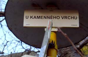
KAMENNÝ VRCH U KŘENOVA
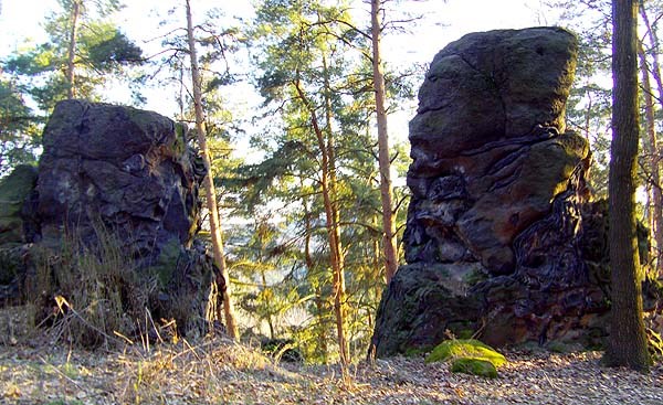
V jižní části Kokořínska u silnice č. 259 mezi Dubou a Mšenem je poblíž obce Křenov kopec Kamenný vrch.
Památka je na vrcholu zalesněného kopce chráněna jako geologická zvláštnost. V pískovcové skále přesycené železitými sloučeninami (hydroxidy železa) vznikly tvary podobné růžím a mísám.
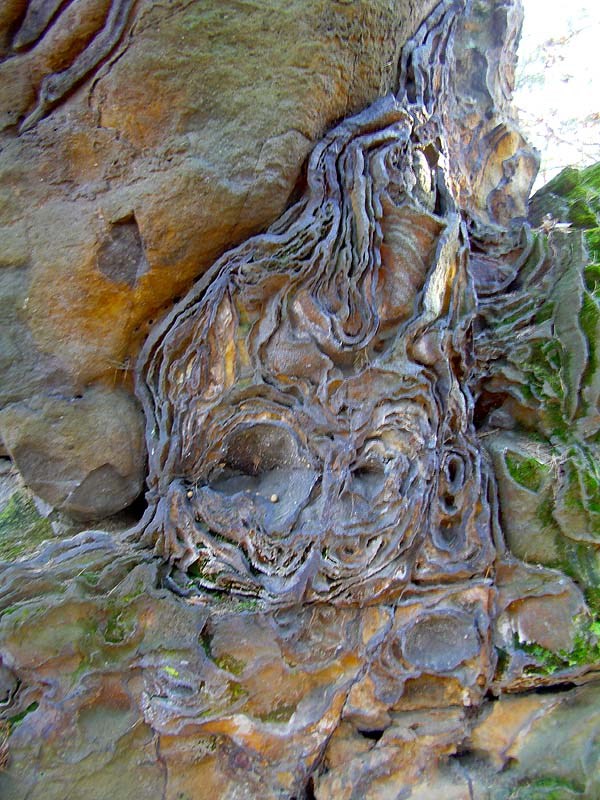
Tyto skalní tvary – inkrustace - vzniklé selektivním zvětráváním hornin jsou chráněné.
Necelý 1 km na západ vede silnice z Dubé na jih do Mšena. Přímo pod kopcem, 200 metrů na východ je rozcestí Pod Kamenným vrchem, křižovatka pěších turistických cest, červené, zelené a modré. Z Dubé se k ní dostanete po červené (asi 3 km) či modré.

Doporučený přístup je právě od rozcestí Pod Kamenným vrchem , kde kromě zjištění některých odpovědí je i možnost parkování (neparkujte přímo na cestě - je třeba zachovat průjezdnost). Pokračujte po přístupové cestě víceméně rovnou "za šipkou" až na cca 300 m vzdálený vrchol kopce s přírodní památkou.
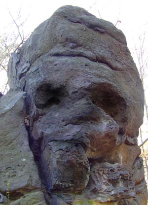
Minibonus : Opřete-li se zády o nižší z obou skal, pak pohlédnete-li na vyšší skálu, můžete spatřit ducha skrytého v tomto skalním masivu, jak na vás přívětivě shlíží.
Památka je chráněná zákonem, je tedy zakázáno ji jakkoliv poškozovat,
vstupovat na ni, provádět horolezeckou činnost a podobně.
Pro úspěšné zalogování je třeba zaslat odpovědi na tyto otázky :
- Zašlete váš odhad výšky skalní věže
- Určete název horniny, kterou je tvořena skalní věž.
- Změřte nadmořskou výšku vrcholu kopce s NPP
- Jak velká je plocha národní přírodní památky ?
- Ve kterých letech byla vyhlášena NPP ?
- Budeme rádi pripojíte-li k logu fotografii (nepovinné).
Upozornění pro logující :
A) Kdo chce logovat, musí poslat odpovědi. (při skupinovém odlovu bude log ponechán pouze tomu, kdo odpovědi zaslal, ostatním bude smazán, viz pravidla)
B) Nejdríve odeslat odpoved , pak logovat!!! Nemám-li odpovědi log ihned mažu.
C) Zalogujte si cache ihned po odeslání odpovedí, pokud by byla nejaká chybka, ozvu se.
KAMENNÝ VRCH (STONE HILL) NEAR KŘENOV
There is a Stone Hill (Kamenný kopec) at the southern part of Kokořín area near the road No. 259 between the oaks Dubá and Křenov.
This monument, which is on the top of the wooded hill is protected as a geological curiosity. In the sandstone saturated with ferric compounds (iron hydroxides) are formed shapes like roses and bowls.
These rock shapes – incrustation - caused by selective weathering of rocks are protected.
Less than 1 km to the west there is a road from Duba to Mšeno southwardly. Directly below the hill, 200 meters to the east there is crossroad “Pod Kamenným vrchem”, the intersection of red, green and blue hiking paths. You can get there by the red tag (about 3km) or by blue.
The recommended approach is just below the intersection “Pod Kamenným vrchem”, where in addition to finding some of the answers there is a parking (don’t park on the road - it is necessary to maintain passability). Continue along the access road more or less straight "by arrow " up to about 300 m distant hilltop with a natural monument.
Minibonus: Lie with your back to the lower of the two rocks, then look at the rock above, and now you can see the spirit hidden in the rock mass, as he looks down graciously at you.
The monument is protected by law. It is prohibited to damage it, enter it, and carry out activities like climbing.
For a successful login it is necessary to send the answers to these questions:
- Send your estimation of the height of the rock tower
- Specify the name of mineral from which is rock tower made up.
- Measure the altitude of the top of the hill with the IAP
- How big is the area of national natural landmark? (look at the map at parkpoint)
- In which years was IAP announced? (look at the map at parkpoint)
- We will be glad if you attach photo to the log (optional).
After submitting your answers do not expect to confirm the accuracy and automatically log this earthcache. When any of the answers is not correct, I will contact you.
HINWEIS : DIESE CACHE IST KEINE KLASSISCHE !!
S uchen Sie also keine Cache am angeführten Koordinaten , weil Cache gibt¨s hier keine!
Naturreservat Steinberg (Kamenný vrch) bei Křenov (Krönau)
Im Süd-Teil von Gebiet um Kokorschin (Kokořín),an der Straße Nr.259 zwischen Dauba (Dubá) und Wemschen (Mšeno) ,befindet sich in der Nähe der Gemeinde Krönau (Křenov) der Berg Steinberg (Kamenný vrch). Das Denkmal auf dem bewaldetem Gipfel als geologische Besonderheit geschützt ist.
Auf der Oberfläche den Sandfelsen , die mit Eisenverbindungen übersättigt sind (Eisen-hydroxid), Entstanden ähnliche Formen wie Rosen und Schüsseln.
Diese Felsenbildungen – Inkrustationen – mit selektiverer Witterung enstehende - zu schützen sind.
Weniger als 1 km nach Westen eine Straße von Dauba (Dubá) südwärts nach Wemschen (Mšeno) führt.
Direkt unter dem Berg , 200 Meter ostwärts, befindet sich Kreuzweg „“Unter dem Steinberg“, den Wanderfußwegen-Kreuzung, rot, grün und blau. Von Dauba (Dubá) kommen Sie zu ihr durch das rote
(zirka 3Km) oder durch das blaue Zeichen.
Empfohlener Zutritt ist gerade vom Kreuzweg Unter dem Steinberg , wo kann man außer einigen Antworten – Feststellungen auch Parkenmöglichkeit gibt´s. (parken Sie nicht direkt auf dem Weg, es ist notwendig die Gelandegängigkeit bestehen zu lassen ).
Gehen Sie bitte fort Zufahrtwegs im großen ganzen direkt hintennach dem Pfeil bis zu zirka 300 Meter entfernte Gipfel des Naturdenkmales.
Miniaturbonus :
Stützen Sie sich mit dem Rücken an die niedrigere von den beideren Felsen, dann, wenn Sie auf den höheren Felsen nach oben schauen , können Sie einen Geist bemerken, der in diesem Felsenmassiv versteckt ist – wie an Sie freundlich aufschaut
Das Denkmal ist gesetzlich geschützt , verboten ist es beschädigen , an das Felsen eintreten, Alpinistik Ausüben und ähnliche…
Für erfolgreichen Login es notwendig ist die Antworten an diese Fragen senden :
1. Senden sie Ihre Höheschätzung des Felsturmes
2. Legen Sie Gesteinename fest , mit der das Felsturm gebildet ist
3. Messen Sie die Seehöhe der Bergkuppe mit dem Nationalnaturdenkmal
4. Wie groß ist die Fläche des Nationalnaturdenkmales ?
5. In welchen Jahren als Nationalnaturdenkmales durchgegeben wurde ?
6. Es wird uns freuen, wenn Sie zum Login eine Aufnahme anhängen – es ist nicht aber pflichtig
Hinweise für Logierene :
A)Wer logieren will, muss die Antworten senden (beim „Gruppenfang“ wird nur dem Mensch behalten, der die Antworten sandte , den anderen wird ausgelöscht (sieh die Regeln )
B) Zuerst die Antwort senden, dann logieren !!! Wenn ich die Antworten nie habe, sofort lösche ich aus !
C) Logieren si die Cache sofort nach dem Antwortenversand , wenn irgendwelcher Fehler gibt’s, melde ich
mich bald ,werde ich Ihned kontaktieren