Perguntas:
Para logar esse EarthCache, envie as respostas às perguntas abaixo através de email usando o meu perfil no geocaching.com. Coloque o texto "GC3AHZ1 – Praia da Guarita – Torre do Centro" na primeira linha do email. Os cachers que não enviarem as respostas em no máximo 2 semanas terão suas entradas removidas.
1 – Mande um email (não publique) Qual a cor do arenito que se encontra na base da Torre do Centro? Qual o tipo de mineral que pode estar associado ao quartzo do arenito para criar esta cor?
2 – Mande um email (não publique) Descreva as características das rochas presentes na zona de contato entre o arenito e o basalto. As rochas na zona de contato são exatamente iguais a ao restante do arenito abaixo e ao basalto acima? (coloração?, granulação?)
3 – Mande um email (não publique) Identifique algumas das estruturas características do derramamento basáltico encontradas nas rochas basálticas da Torre do Centro (Disjunções Colunares? Basalto Amigdalóide? Disjunção Tabular?)
4 – Tire uma foto sua com o seu GPS em mãos nas coordenadas do EarthCache com a Torre do Centro ao fundo e coloque no seu log. (opcional)
*! Parabéns Dekaru por ter sido o primeiro a logar este earthcache!*
Questions:
To log this EarthCache, cachers are asked to e-mail the answers to the following questions to me through my geocaching.com profile. Add the text "GC3AHZ1 – Praia da Guarita – Torre do Centro" to the first line of the email. Cache loggers that do not send me answers within 2 weeks will have their logs deleted.
1 – Send an email (do not post) What is the sandstone color on the base of the Tower? What type of mineral can be associated to quartz in the sandstone to create this color?
2 – Send an email (do not post) Describe the characteristics of the rocks present in the area of contact between the sandstone and the basalt. Are the rocks in the contact zone exactly equal to the rest of the sandstone below and the the basalt above? (color?, grain size?)
3 – Send an email (do not post) Identify some of the characteristic structures of the basaltic rocks found on the Tower (Columnar Disjunctions? Amygdaloid Basalt? Tabular Disjunction?)
4 – Take a picture of yourself with your GPS in hands at the EarthCache coordinates with the Torre do Centro in the background and add it to your log. (optional)
*!Congratulations Dekaru for the First To Find!*
Introdução/Introduction
As coordenadas do EarthCache estão localizadas aos pés da Torre do Centro na Praia da Guarita. A Torre do Centro é um dos morros da Praia da Guarita em Torres, Rio Grande do Sul, Brasil e tem sua existência geológica datada de aproximadamente 140 milhões de anos, idade do Basalto Serra Geral e do Arenito Botucatú que a forma. A sua forma atual de falésia a beira mar - única em todo o Litoral do Rio Grande do Sul, é o resultado de alterações feitas pelas intempéries na era Cenozóica, principalmente no período Quaternário quando, ao longo dos últimos 230 mil anos quatro transgressões e regressões marinhas afetaram a região finalizando com o última transgressão há 11 mil anos.
Praia da Guarita / Guarita Beach![]()
The EarthCache coordinates are located at the foot of the Torre do Centro (Center Tower) in the Praia da Guarita (Guarita Beach). The Torre do Centro is one of the hills of the Praia da Guarita in Torres, Rio Grande do Sul, Brazil, and its geological existence dates back to 140 million years, the age of the Serra Geral basalt and Botucatú sandstone. Its current aspect of cliffs by the sea (falesia) – unique on the Rio Grande do Sul coast, is the result of weather changes in the Cenozoic era, especially in the Quaternary period. Over the past 230,000 years four marine transgressions and regressions hit the region with the last transgression ending 11 thousand years ago.
Formação Botucatú / Botucatú Formation
A cerca de 180 milhões da anos atrás, o continente de Gondwana havia se separado do continente da Laurásia após estarem juntos por 120 milhões de anos. Esta quebra e o lento reposicionamento dos continentes teve dramáticas consequências no clima dos continentes e na circulação de correntes oceânicas.
A 151 milhões de anos no Jurássico Superior, o posicionamento continental de Gondwana e suas características de relevo criou um padrão climático no interior sul do continente resultando na criação de um imenso deserto. Durante aproximadamente 20 milhões de anos, no território onde hoje se localiza a Pedra da Guarita, pouca chuva, muita poeira e ventos ininterruptos formou um deserto de dunas construídas com areia de granulação em geral fina ou média. O tipo de disposição das camadas, formando pacotes com mudanças bruscas de inclinação; o aspecto fosco dos grãos, consequência do atrito causado pelo transporte pelo vento; a ausência de fósseis e a presença apenas localmente de água caracterizam muito bem esse clima desértico.
Tempestades de areia formaram um deserto de dunas equivalente em tamanho e características fisiográficas ao atual deserto do Saara localizado no norte da África. Durante os 20 milhões de anos em que as condições climáticas persistiram, as dunas direcionadas pelo vento criaram depósitos de areia e, camada após camada teve suas características preservadas. Geólogos estudando as características das rochas formadas a partir das areias deste deserto chamaram este vasto deserto de Deserto Botucatú. O deserto avançava sobre boa parte do território das atuais regiões sudeste e sul do Brasil e partes significativas dos países vizinhos, alcançando um total de 1.200 milhão de quilômetros quadrados.
A areia das dunas, pela cimentação provocada após longo tempo de deposição, transformou-se em rocha, uma rocha conhecida como Arenito. Os ventos que moviam as dunas sopravam principalmente de N a NE. Atualmente isso é facilmente visualizado pelas linhas estratificadas presentes no arenito. Os arenitos da formação Botucatú são compostos, em mais de 95%, de grãos de quartzo médios ou finos, quase não existindo silte ou argila (materiais com granulação ainda menor), e podem conter pequena fração de outras rochas (quartzite e feldspato). Com frequência os grãos estão envoltos por óxido férrico, que torna a rocha mais coesa e lhe dá coloração avermelhada ou amarelada.
O Deserto Botucatú sobreviveu até 134 milhões de anos atrás. Novos fenômenos geológicos iniciados pela quebra do continente de Gondwana não só alteraram a feição geológica mas também alteraram os padrões climáticos que produziram e mantinham o deserto.

Formação de dunas e sua posterior transformação em uma rocha sedimentar. Os estratos nestes depósitos representam as camadas de areia que formavam as antigas dunas. / Dunes and their subsequent transformation into a sedimentary rock. The strata in these deposits represent the layers of sand dunes that formed the old.![]()
Adaptado de/Adapted from: Georoteiros (www.georoteiros.com.br)
Around 180 million of years ago, the Gondwana super continent had separated from the continent of Laurasia after being together for 120 million years. This break down and the slow reposition of the continents had dramatic consequences on the climate of the continents and the circulation of the ocean currents. In the Upper Jurassic, 151 million years ago, the Gondwana position in the planet and relief created a climate pattern in the interior of the southern part of the continent which resulted in the creation of a vast desert. For approximately 20 million years, in the territory where now stands the Torre do Centro, little rain, dust and wind formed an unbroken wilderness of sand dunes built by fine to medium grained sand. The type of disposition of the layers, forming packets with sudden changes in slope, the matte appearance of the grains result of friction caused by the wind transport, the absence of fossils and the presence of water only locally well characterize this desert climate.
Sandstorms formed a sand dunes desert equivalent in size and physiographic characteristics to the Sahara desert located in northern Africa. During the 20 million years the climatic conditions persisted, the dunes created and directed by the wind created sand deposits, and layer after layer had its characteristics preserved. Geologists studying the characteristics of the rocks formed from the sands of this vast desert called it Deserto Botucatú (Botucatu Desert). The desert advanced over much of the territory of today's southeastern and southern Brazil and significant parts of neighboring countries, reaching a total of 1.200 million square kilometers.
The sand from the dunes, cemented after long deposition times turned into rock, a rock known as Sandstone. The winds that moved the dunes were blowing mainly from N to NE. Currently this is easily seen by the lines present in the stratified line on the sandstone. The sandstones of the Botucatu Formation are composed by more than 95% of medium or thin quartz grains, with almost no silt or clay (smaller-grained materials) and may contain small fraction of other rocks (quartz and feldspar). Often the grains are surrounded by ferric oxide, which makes the rock more cohesive and gives it a reddish or yellowish color.
The Botucatu Desert survived until 134 million years ago. New geological phenomena initiated by the break down of the Gondwana continent not only altered its geological aspects, but also the weather patterns that created and maintained the desert.
Formação Serra Geral /Serra Geral Formation
Há cerca de 135 milhões de anos, no início do período Cretáceo, as placas tectônicas que constituíam o super continente de Gondwana começaram a se mover. Erupções vulcânicas de grande escala começaram a ocorrer na região da atual pedra da Guarita, mas diferente de explosões vulcânicas tradicionais, o magma que começava a recobrir vastas extensões do deserto provinha de fissuras no chão. Não sendo um processo de vulcanismo explosivo, mas de inundação, as lavas, muito fluidas, a 1200 graus centígrados, espalharam-se sobre as dunas de areia, preservando suas formas.
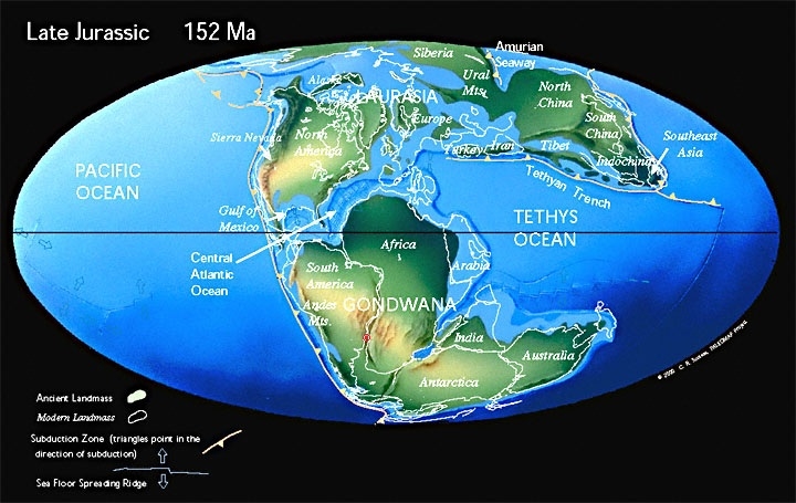
![]()
Gondwana – o ponto vermelho marca a origem do magma (hot-spot) / The red spot shows the magma origin (hot-spot)
O magma expelido recobriu toda a porção centro-oriental da América do Sul, cobrindo total ou parcialmente os estados brasileiros do Rio Grande do Sul, Santa Catarina, Paraná, São Paulo, Mato Grosso, Mato Grosso do Sul, Goiás e Minas Gerais, além de parte do Uruguai, Argentina e Paraguai e estendendo-se a até o noroeste da Namíbia. Esses derramamento basáltico criou a Bacia basáltica do Paraná-Etendeka, conhecida no Rio Grande do Sul como Formação Serra Geral. A área de distribuição do magma de basalto cobriu aproximadamente 1.200.000 km2 com uma espessura média em torno de 700 metros. Treze derrames basálticos consecutivos, com camadas de espessuras entre 15 e 55 metros, ocorreram nos 10 milhões de anos em que o processo esteve ativo. As camada consecutivas de basalto cobriram o arenito e as dunas do Deserto Botucatú. Todo o planalto da Serra Geral que hoje se estende pelo sul do Brasil é o resultado destes derrames conhecidos como Paraná Traps e foi a segunda maior ocorrência de grandes derrames de lava basáltica do mundo. O volume total de magma basáltico derramado no Paraná Traps é estimado em 8.600 km3.
Durante todo o tempo em que os derrames basáltico estavam ocorrendo, o super-continente Gondwana continuava a se dividir, separando os continentes Sul Americano e Africano que lentamente se afastavam. A separação entre os continentes criou um vale Rift – assim como o que existe atualmente no leste da Africa. As terras baixas do centro do Rift foram tomadas pelo futuro oceano do Atlântico Sul. O local original do hot-spot atualmente se localiza sob o arquipélago de Tristão da Cunha.

Sobreposição da Formação Serra Geral à Formação Botucatú / Superposition of the Serra Geral Formation over the Botucatu Formation![]()
In the early Cretaceous period, around 135 million years ago, the tectonic plates that made up the Gondwana super continent began to move. Large-scale volcanic eruptions began to occur in the region of the current Torre do Centro, but unlike traditional volcanic eruptions, the magma that began to cover vast expanses of the desert came from cracks or fissures on the ground. Not being a process of explosive volcanism, but of lava flood, the very fluid lavas at 1200 degrees centigrades, spread on the sand dunes, preserving its forms.
The expelled magma covered all central-eastern portion of South America, covering all or part of the Brazilian states of Rio Grande do Sul, Santa Catarina, Parana, Sao Paulo, Mato Grosso, MatoGrosso do Sul, Goias and Minas Gerais, in addition to parts of Uruguay, Argentina and Paraguay and extended up to the northwest Namibia. This lava flow created the Basin of the Parana-Etendeka basalt, known in Rio Grande do Sul as the Serra Geral Formation. The basaltic magma distribution covered approximately 1,200,000 km2 with an average thickness of 700 metres. Thirteen consecutive basaltic layers with thicknesses between 15 and 55 metres, occurred in 10 million years in which the process was active. The sequenced layers of basalt covered the sand dunes and the sandstone of the Botucatu desert. The whole Serra Geral plateau which today extends across southern Brazil is the result of these floods known as Parana Traps, and are the second biggest occurrence of basaltic lava flows in the world. The total volume of basaltic magma poured into the Parana Traps is estimated in 8,600 km3.
During the time the magma floods were occurring, the super-continent Pangea continued to break-up, separating the South American and African continents, which slowly drifted away. The separation between the continents created a Rift Valley – just like the one that currently exists in East Africa. The lowlands in the centre of the Rift were taken by the future South Atlantic Ocean. The original location of the hot-spot is currently located below the islands of Tristan da Cunha.
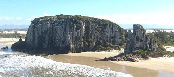
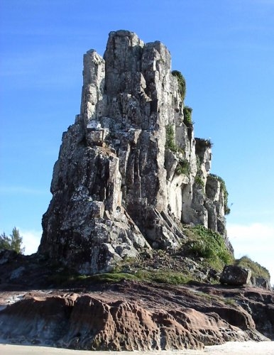
Torre do Centro – Praia da Guarita /Central Tower – Guarita Beach
A região onde hoje se localiza a região de Torres e a Torre do Centro é a única do Brasil em que os basaltos da Formação Serra Geral chegam até o mar. Ao juntar-se os mapas da América do Sul e da África é possível identificar naquele continente o ponto que outrora ligava-se a este onde hoje é a localidade de Torres. Este é o Cabo Cruz (Cape Cross). Torres e o Cabo Cruz são os únicos lugares em que os basaltos da formação Serra Geral (na África, chamados de Formação Etendeka) chegam até o mar. Cabo Cruz é uma praia arenosa, com morros de basalto e uma laguna, onde os falhamentos principais têm a mesma direção que em Torres e o basalto da da Formação Etendeka cobre um arenito igual ao Botucatu (arenito Cave).
Observando-se com atenção o conjunto de rochas que constituem a Torre do Centro, pode-se visualizar a interação entre os dois eventos geológicos descritos acima.
O primeiro evento – a Formação Botucatú, está registrado nos arenitos observados na base da Torre. Esses arenitos podem ser reconhecidos por apresentarem estruturas internas características, em geologia chamadas de estratificações, e que são de grande auxílio na interpretação dos mecanismos de transporte e deposição de sedimentos que criaram o arenito. As estratificações nesses arenitos são dos tipos cruzadas e plano-paralelas (embora essas últimas apareçam mais raramente nesse local).
O Segundo evento – os derramamentos basálticos que deram origem a Serra Geral são visíveis acima das camadas de arenito estendendo-se até o topo do morro. Os magmas de baixa viscosidade gerados nos derramamentos formaram “lagos de lava” que uma vez solidificados em basalto apresentam estruturas características de acordo com o processo de solidificação: Disjunções Colunares devido à perda de calor em direção às bordas do derrame (contração devido à diminuição do volume); elementos arredondados – buracos ou esferas contendo outros minerais e caracterizando o chamado Basalto Amigdalóide devido à subida de gases para o topo do derrame (mesmo fenômeno observado ao se abrir uma garrafa de refrigerante) e Disjunção Tabular devido ao atrito da base do derrame com o substrato.
![]()

Exemplo de derrame basáltico / Example of basaltic flood
Fonte/Source: Georoteiros (www.georoteiros.com.br)
The region where today is located the region of Torres and the Torre do Centro is the only in Brazil where the Serra Geral Formation basalts reach the sea. By joining the maps of South America and Africa it is possible to idenfify on that continent the point that once was linked to what is now the region of Torres.This is the Cape Cross. Torres and Cape Cross are the only places where the basalt of the Serra Geral formation (in Africa, called the Etendeka Formation) reach the sea. Cape Cross is a sandy beach with basalt hills and a lagoon, where the major faults have the same direction as in Torres and the basalt of the Etendeka Formation covers a sandstone equal to the Botucatu sandstone (Cave sandstone).
Carefully observing the set of rocks forming the Torre do Centro, one can visualize the interaction between the two geological events described above.
The first event – the Botucatu Formation, is registered in the sandstones observed in the base of the Tower. These sandstones can be recognized by the characteristics of their internal structures, called stratification in geology, and which are of great help in interpreting the transport mechanisms and deposition of sediments that created the sandstone. The stratifications in these sandstones are crossed and plane-parallel (although the latter appears more rarely).
The second event - the basalt flows which created the Serra Geral are visible above the sandstone layers and extending to the top of the tower. The low viscosity magmas generated in the flood formed "lava lakes" that once solidified into basalt exhibit structures characteristic to the solidification process: Columnar Disjunctions due to heat loss from the edges of the spill (contraction due to decreased volume); rounded elements – spheres containing holes or other minerals and characterizing the so-called Amygdaloid Basalt created due to rising gas to the top of the spill (the same phenomenon observed when opening a bottle of soda);and Tabular Disjunction created by the friction of the spill with the substrate at the base.
Torre do Centro – Praia da Guarita![]()
Cessado o vulcanismo há cerca de 100 milhões de anos, a região onde hoje existe a Torre do Centro presenciou várias oscilações do nível do mar (transgressões e regressões), que levaram a sucessivas fases de deposição de sedimentos e de erosão do seu material, resultando na torre que hoje se vê. O mar está há pelo menos 2.000 anos em fase de regressão, o que explica o grande número de lagoas e lagunas de planície costeira do Rio Grande do Sul.
A Torre do Centro é um monumento geológico que conta uma história de 150 milhões ao longo dos seus 25 metros de altura. N escultura da natureza encontramos informações geológica que falam sobre grandes desertos, separação de continentes, gigantescos derramamento de lavas, avanços e recuos do mar e erosão.
Ceased the volcanism around 100 million years, the region where now stands the Torre do Centro witnessed several sea level oscillations (transgressions and regressions), which led to successive phases of sedimentation and erosion of its material, resulting in the tower seeing today. The sea has been in a regression phase for the last 2,000 years, which explains the large number of ponds and lagoons in the coastal plains of RioGrande do Sul
The Torre do Centro is a geological monument that tells a story of over 150 million on its 25 meters high. In this nature’s sculpture we can find geological information that talk about great deserts, the separation of continents, huge lava flows, advances and retreats of the sea and erosion.
