Taieri River View (South Otago) Traditional Cache
Taieri River View (South Otago)
Please note Use of geocaching.com services is subject to the terms and conditions
in our disclaimer.
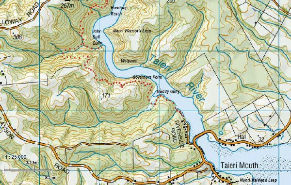
You're sure to enjoy this attractive walk to a seat with magnificent views of the Taieri River. If you can arrange two cars or a cross-over with friends, it is fun to continue to the Taieri Ferry Road on the Millenium track - the total distance one way is 7 1/2 km.
It is 3 km from the carpark at the end of Riverside Rd to this viewpoint, a steady climb of 235 m which takes under an hour one way for adults. It's an ideal family walk; it's sheltered, and once you turn back it's downhill all the way for tired legs. If you're with children, expect to spend time at the Muddy Gully boardwalk watching the mudcrabs!
The track is well-formed, but is damp and a bit slippery where it passes through the ferny gullies. You are looking for a black 2 litre screwtop on the upper side of the track, reachable from the track.

The Department of Conservation Taieri River Track description explains why this walk is special:
The track passes through several different types of vegetation and terrain. Because of the river's tidal nature in its lower reaches, the first part of the track passes both freshwater and saline plant life. As it climbs the track enters a lush podocarp forest with superb specimens of Halls totara, tree fern/katote and miro. There are also good stands of healthy, regenerating kahikatea, New Zealand's tallest native tree. As Kahikatea thrives in fertile soil which has usually become farmland, regenerating stands like this are very rare. After the forest the track passes through open shrubland to a seat at a viewpoint.
Traffic on the Taieri River nowadays is likely to be fishers, boaties or kayakers. But up until a hundred years ago, it was a main highway for Maori, settlers, goldminers and tourists between the coast and the Taieri Plains. Humbug Reach was named for the cross-winds and undercurrents hindering progress up this part of the river. “When gold was found in Gabriels Gully in 1861 the Taieri River woke to busy activity as coastal boats, cutters and schooners of from 50 to 100 tons brought goods from Dunedin up river to Taieri Ferry for transshipment. At the height of the goldrush it was not unusual for up to a dozen vessels to be seen anchored at Taieri Mouth.”
Past the viewpoint it is another kilometre downhill to the John Bull Gully picnic table. This gully is named after an old identity who grew his vegetables here, using only a bivvy or his upturned whaleboat as an overnight shelter. John Bull (real name John Williams a.k.a. Robert O'Neill) was originally from Halifax, North Carolina, jumped ship from an American warship to join a whaler and sealer, and arrived at Otakou around 1830. He “found it overpopulated after the arrival of the settlers” and moved to Maitapapa where from 1852 he operated the Taieri Ferry punt. After the death of his wife Apaikia in the late 50s he moved to Taieri Mouth and became the first ferry man there. “For all his uncouth ways and a predilection for liquor, he was admired for his astonishing strength and accepted for his gruff helpfulness.” Obituary (1884). An Attractive Holiday Resort: The Lower Taieri (1905). Further stories about John Bull are in log notes below.
Upriver you can see the best-known landmark on the river, Maori Leap; it turns out that there are two. The Maori Maiden’s Leap is at the mouth of the river, where in the early 1700s Haki Te Kura jumped to her death from Motupara pa while attempting to join her lover Koroko Whiti. The Maori Warrior’s Leap, opposite John Bull's Gully, resulted from this first death. Haki Te Kura’s father sent three Te Moua chiefs to kill Koroko Whiti and all his party, except for two young boys who escaped. When those boys had grown to be young men in the 1720s they returned with a war party, and by a stratagem killed two of the Te Moua chiefs. The last Te Moua chief, Te Hoki Kairaki, fled towards the coast. The warparty’s chief Tu Pare Taniwha chased Te Hoki Kairaki to the top of the cliff above the Taieri, and speared him as he jumped from that height.
The headland opposite the viewpoint is called Waipawa, apparently because Maori soaked paua in the creek here before eating.
A landmark which can only be seen from the river is Governor’s Chimney, a cliff and tall rock pinnacle where Governor Sir George Grey had lunch during a trip down the river in March 1867.
Out to sea is Moturata or Taieri Island. A whaling station owned by the Weller brothers operated here from 1839- 41. It was briefly reopened by Johnny Jones in 1844, managed by Tommy Chasland a "half caste Australian". A pilot station was established on the island in 1862 after three successive wrecks on the Taeri Mouth bar in 1861, but closed in 1864 after roads replaced the river route to the gold diggings.
Additional Hints
(Decrypt)
Zncbh/Erq zngvcb, hccre fvqr bs genpx, ernpunoyr sebz genpx
Treasures
You'll collect a digital Treasure from one of these collections when you find and log this geocache:

Loading Treasures