Haere Mai ki Huriawa (East Otago) Multi-Cache
Haere Mai ki Huriawa (East Otago)
Please note Use of geocaching.com services is subject to the terms and conditions
in our disclaimer.
Haere Mai ki Huriawa - Welcome to Huriawa!
This easy multi takes you on a short walk around the historic Huriawa pa site at Karitane. Counting the number of letters in particular word/s on each of the eight information boards will lead you to the final.
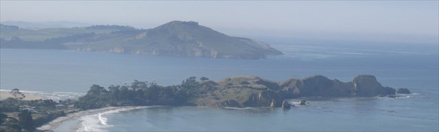
“Huriawa” means “turning river”, showing that the Waikouaiti River at times cut across the isthmus linking the peninsula with the mainland. This rugged sandstone headland is regarded as the strongest defensive structure of its type in Otago and one of the most impressive earthworks in Te Waipounamu (the South Island). In pre-European times Southern people were primarily hunters and gatherers (kumera could not be grown south of Banks Peninsula) and therefore there were few fortified pas. This pa was built originally by Käti Mamoe and known as Pa-katata (now the name of the rocky promontory at the seaward end). It was strengthened and expanded by the Kai Tahu fighting chief, Te Wera, about 1750.
Huriawa is owned by Te Runanga o Ngai Tahu. It is jointly managed by Kati Huirapa Runaka ki Puketeraki and the Department of Conservation. The runaka have given approval for this cache.
WARNING: There are UNPROTECTED CLIFFS around Huriawa, particularly at Waypoints 3 & 4 beside the Blowholes. Although there is no danger provided you stay on the track, ensure that children are kept safe.
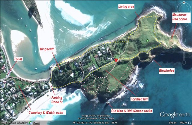
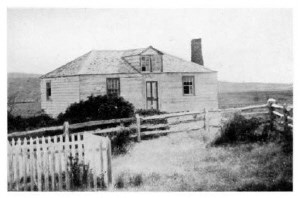
Park at Rona Rd (there is very limited parking at the entrance gate) and walk up Sulisker St. This follows the original track to the pa. On your left (not visible from the road) is Kingscliff, Dr Truby King’s house. Truby King was Medical Superintendant of Seacliff Lunatic Asylum. He is best remembered for founding the Plunket Society in 1907.
The gateway to the pa, known as “The Ngutu (Lips) of Toretore” was at the top of this rise. We all know how difficult mussels (toretore) are to open!
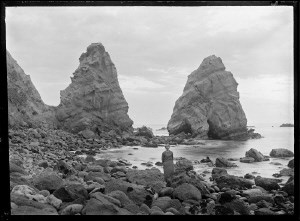 Before you start the interpretive walk, you may like to explore the southeastern side of Huriawa (the tracks marked in pink on the map). The runaka, helped by local schools, are replanting native vegetation. They have established a nursery and are growing plants from local sources. It’s hoped that revegetation will encourage hoiho (yellow-eyed penguins) and korora (little blue penguins) to nest and breed here again, especially if they are provided with nesting boxes. The track goes down to a small cove with a good view of two rock pinnacles. These are the Old Man, Maramai Te Whata (Left from the Storehouse) and closer to land the Old Woman, Ariki Te Araroa (Shaken to Life). A smaller rock nearby represents a child.
The steep hill beside the road, now partly cut away by road widening, was the main fortification of the pa. At the west side of the peninsula stood the carved house Kuramatakitaki. Archaeological excavations in the 1960s found postholes showing that the hilltop was once heavily defended with earthworks and rows of palisades. A house site was found on one of the terraces.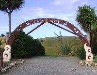
The interpretative walk around the pa site, and this multi, begins at the end of Sulisker Road. The Tiakitaka archway, carved by James York from totara and Oamaru limestone, was unveiled in 2002.
A donation box is on the right of the archway; if you wish to give a koha, it will be used for further improvements.
Sign 1: Welcome
Guarding [ A ], Kuramatakitaki
A = number of letters in omitted word/s
As various hapu of the Ngai Tahu migrated southwards into Otago in the mid-1700’s, there was rivalry between the different branches of the iwi. A feud between the relatives Taoka and Te Wera led to the famous siege of Huriawa pa about 1770.
There are different versions of events, and even the identity of Te Wera is uncertain (there were several warriors by that name, and their exploits have probably become conflated). One variant was retold by Beattie in J Polynesian Society (1916) Vol 25 (97) The Coastal Wars (scroll down to p 15 of the article). A detailed story was published by J Cowan in the Otago Witness 31 January 1906.
The son of Moki, a chief living with Kati Mamoe people in Pukekura Pa at Taiaroa Head, died from makutu (witchcraft). Te Wera was one of the suspects attacked by Moki. Taoka was called in as peacemaker, but insulted Te Wera, and in retaliation Te Wera killed Taoka’s son. Te Wera then retreated to Huriawa Pa, stripping the surrounding country of food and laying in stores of preserved birds, fern root and dried fish for a siege. Taoka arrived by sea and set up camp on the sandspit Ohinepouwera opposite Huriawa.
Taoka’s warriors performed a haka and threatened:
Me whakatiki koutou ki te wai!
We will starve you out!
Te Wera defiantly replied:
E kore ai, e kore au e mate i te kai! E kore mā te matua whakatakoto ki Te Kutu o Toretore, e kore e taea! Engari mā te matua mate wai, ka mate au!
Never, never! We will never die of hunger! Nor will we be conquered by your forces gathered below the Lips of Toretore! It is only by the power of thirst that we may be overcome!
Sign 2: Te Puna Wai a Te Wera (Te Wera’s Spring)
Te Wera needed this [ B ], this life-giving spring
B = number of letters in omitted word/s
Huriawa had the unusual advantage of having a fresh water spring within it. A covered trench led down to the spring, concealing people fetching water from the enemy. A small pool used to be by the spring in all but the driest weather, but this was drained by an earth movement in 1943.
Sign 3: Nga Pehu (The Blowholes)
A long time ago two [ X = number of letters in word] [Y = number of letters in word]
C = X – Y
 These blowholes are explained by a myth. A young couple married against their parents’ will, but returned a year later seeking forgiveness. The hard-hearted parents took the lovers to the Puke Maeroero hills behind Puketeraki lookout and threw them off. The pregnant woman, being heavier than her husband, caused the larger blowhole closer to the beach. Out to sea are the Hongihongi rocks, looking like two women pressing noses.
Sign 4: Kahukura
Te Wera the Hot, Hautu he [ D ]
D = number of letters in omitted word/s
James Cowan retells the Legend of the Stealing of the Atua. At low tide, two of Taoka’s men crept in through one of the blowholes, climbed the cliff and stole the carved image of the war god Kahukura from its shrine within the pa. However, Te Wera’s tohunga Hautu consulted the oracles and chanted powerful karakia. The god Kahukura flew through the air and returned to the pa.
Sign 5: Te Awa Mokihi (Raft Bay)
Look ahead to [ E ]
E = number of letters in omitted word/s
In this sheltered bay, also called Butterfly Bay, Te Wera kept his canoes. The larger ones are said to have been kept in reed-thatched sheds. Even during the siege, people were able to go out on fishing expeditions. The present name of the area, Karitane, is said to come from an incident during the siege when all the fit men left to gather food, leaving only the crippled and wounded men to defend the pa. As well as providing a landing place for canoes in most weathers, the bay was famous for its paua.
On the eastern side of the bay, the cliff face called Maukoroa has deposits of red ochre. This kokowai was mixed with shark liver oil and used for adornment and to decorate carvings, canoes etc. On the western side of the bay is a pou or boundary post, marking ownership.
The headland you see to the north is Matanaka, where Johnny Jones began farming in 1840. The historic 1843 farm buildings, among the oldest in the country, are worth visiting (closed for lambing mid-August to September), as is Matanaka cache. Jones’ farms here and at Cherry Farm, together with his far-reaching shipping interests, ensured regular food supplies to Dunedin when it was settled in 1848.
Sign 6: Living Area
On these terraces they dried [ F ]
F = number of letters in omitted words (to the end of the line)
Terraces were made on this sheltered sunny area for living areas and house sites. Excavations in the 1960s found posthole patterns suggesting drying racks. According to tradition, a palisade ran along the northern side of the peninsula which was most vulnerable to attack.
After a siege of six months, Taoka ran short of food and was forced to admit defeat and return home. The pa was abandoned and the inhabitants settled along the banks of the Waikouaiti River. However, during the siege Te Wera had killed his wife Te Honeka for misconduct. Since she was well-connected, Te Wera fled the area for fear of retaliation by her relatives. Some sources say he went to Stewart Island (Rakiura), although this may be a later warrior with the same name.
Pakihaukea, an ally of Te Wera’s, settled in nearby Mapoutahi Pa. After his unsuccessful siege of Huriawa, Taoka attacked and took Mapoutahi in a bloody encounter. 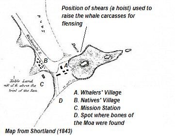
Sign 7: Whaling Station
Stood on the [ G ], across the water
G = number of letters in omitted word/s
Messrs Long and Wright of Sydney sent a whaling party to Waikouaiti Bay in 1837. In 1838 the firm became insolvent, and the whaling station was bought by Johnny Jones for 225 pounds. He made his money back quickly, since a single whale was worth one to two hundred pounds. 41 whales were caught in 1838, with up to 15 whaling vessels in Waikouaiti Bay at one time, but the tally declined rapidly to 9 in 1841. The station closed in 1848.
 Otakou chiefs Karetai and Taiaroa requested a missionary, and Johnny Jones applied to the Wesleyan Mission Board in Sydney. The Rev James Watkin, his wife Hannah and five children arrived on 16 May 1840. This seems to have been a punishment post for Watkin, who apparently had been too affectionate towards the family's Tongan maid in his previous post in Tonga. Watkin preached the first Christian sermon in Otago two days later. He also performed the first Christian marriage in the South Island on 27 January 1841 - between Mere Kuri and James Spencer, who served at Corunna and Waterloo and arrived at Bluff in 1824. Watkin preached in Maori four months after his arrival, published an elementary reading book in December 1841, and by 1843 many of the local Maori had learned to read and write. However, he struggled to reform the “drunkenness and immorality” of the whalers and the “savage customs of the natives". When Watkin left in 1844, he is said to have greeted his replacement Rev Charles Creed by saying “Welcome to Purgatory, Brother Creed”.
Whaling resumed between 1869 and 1877. Several local Maori men had whaleboats built, and took 13 right whales and one humpback. A trypot from this era is in the Waikouaiti museum.
The Waikouaiti Whaling Station site outlines archaeological findings.
Sign 8: Farewell Friends
Our [ H ], our story is freely given
H = number of letters in omitted word/s
A road and coastal walkway lead you back to the carpark. We recommend a detour to visit the historic cemetery. In July 1842 Tautaki, a 35 year old Maori woman, died, and her husband requested a Christian burial. Watkin’s diary records that he gave “huge offence” to “some of the most Christian (?) whites”, particularly the American whalers, by burying a “Native woman” near the grave of Mrs Thomas (wife of the superintendent of Jones’ station) who had died the previous week. A cairn marks the site of Rev Watkin's mission house and the first Christian service in Otago.
The final is at S45 3A.BCD E170 3E.FGH
Checksum: A + B + C + D + E + F + G + H = 42
You are looking for a clear 2 litre snaplock. The hide is located on public land, above ground level and within easy reach without moving off the track.

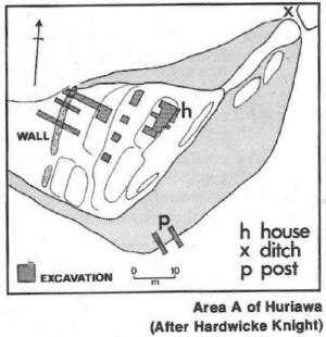 Archaeological map of Huriawa
from Brailsford "The Tattooed Land"
A: defended knob with terracing, palisade and house site
B: Village with terracing and extensive midden
C: possibly a pa, with midden on western slopes, but no earthworks left
D: another possible pa area
Further reading:
Ngai Tahu: A Migration History Te Maire Tau & Atholl Anderson
The Welcome of Strangers Atholl Anderson
The Tattooed Land Barry Brailsford
Karitane by the Sea Ian Church
There is plenty of room in the log book to put in the date that you sign it. Because the date can be important for some challenges, logs without a correct date may be subject to deletion. I will use my common sense and discretion as we all make genuine mistakes at times.
Additional Hints
(Decrypt)
Gvrq gb pnoontr gehax, gur 2aq bar nybat, fvqr bs genpx njnl sebz frn, va ohfurf xarr yriry
Treasures
You'll collect a digital Treasure from one of these collections when you find and log this geocache:

Loading Treasures