
This cache is part of the Historic Boston GeoTour, a series of twelve caches that will take you through the city’s 400 years of history. One of the twelve is a bonus cache which will require you to also complete the Freedom Trail Adventure Labs. Completing the GeoTour will earn you 57 smileys, a Historic Boston GeoTour geocoin, and a Historic Boston digital souvenir.
This accessible urban Earthcache brings you to Boston's Back Bay and three important (even surprising) sites of historic and earth science interest: New Old South Church, Trinity Church and the land of the Back Bay. While the terrain is level with paved routes, you may wish to relax on the Copley Square lawn (weather permitting) as you take in the sites and history.
Please note: Although the cache area is open 24 hours, the stones are best viewed in daylight.
Plums in the Pudding
"Plums in the Pudding"* is a series of developing Earthcaches which, in various ways, hopes to inform and inspire the cacher about Massachusetts' unique and fascinating state rock, Roxbury Puddingstone, as well as the historical and geological settings in which it is found. Further, whenever possible, this series will use locations that are wheelchair accessible.
"Plums in the Pudding II" takes you to Boston's Back Bay, one of the most significant spots of earth science interest in the Boston area. Here we will explore not only the puddingstone in Old South Church but, by way of comparison, investigate other stone in Old South and nearby Trinity Church, as well. Finally, we will examine and directly experience parts of Back Bay's curious and dramatic earth science history and discover how that history significantly affected Old South, Trinity and all of Boston.
A little mental tuning beforehand: Unlike Mission Hill, the historical contextual vibe in Back Bay is not so much one of continuity, cohesion and community as of individualism, industry and ingenuity, its social and geological history often challenging, frustrating, even arduous. So, mentally gear up for the trek! It's a worthy adventure ...with a happy ending!
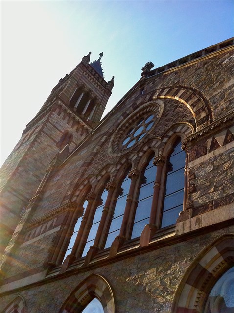
New Old South Church
A little historical context (optional but useful)…
The posted coordinates lead you to magnificent New Old South Church, built and still caringly maintained by the United Church of Christ (Congregationalist). One of the oldest religious congregations in the United States, it was founded by a group of bold individuals who seceded from First Church of Boston over a controversial individual rights issue. Over the years, the church has known many historic persons among its members. Their various stories are beyond the scope and focus of this Earthcache but, briefly, these persons include: Benjamin Franklin; early abolitionist and later women's rights advocate, Samuel Sewall; William Dawes (who rode with Paul Revere and Samuel Prescott during the famous 'midnight ride'); Phillis Wheatley (America's first published African American poetess); and Elizabeth Vergoose (the well-known Mother Goose). Also of interest: Since the first Boston Marathon was run in 1897, Old South Church has been known as "The Church of the Finish Line."
The church's seemingly contradictory official name (New Old South Chruch) can be explained by the congregation's history. Established in Boston in 1669, the United Church of Christ had two previous meeting places in Boston: the Cedar Meeting House (1670) and (in 1729) the original Old South Church (now called the Old South Meeting House). The congregation's latest home, New Old South Church (more commonly referred to as simply Old South Church), was completed in 1875, one of the early constructions in what is now the Back Bay. An important structure at the time of its building, Old South continues to be architecturally and historically significant and is a National Historic Landmark.
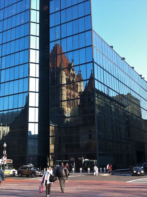
Old South Church was designed by the architectural team of Charles Amos Cummings and Willard T. Sears. It is an acclaimed example of Northern Italian Gothic Revival architecture, one of over 35 Gothic Revival churches built of puddingstone in the 19th and early 20th centuries - those numbers, no doubt, contributing to puddingstone's being named the "church stone" of Boston. Further, puddingstone's coloration and textural qualities resonated with the Gothic style. In fact, as the style in churches migrated to more classical revival, puddingstone fell out of favor in place of lighter-colored stone (as can be seen in Trinity Church, another historically and architecturally important church across the street).
The puddingstone itself…
Interestingly, at Old South, we do not see (as we did on Mission Hill) a personal relationship with a special local stone quarried in one's own backyard (there was no local stone or quarry)** but rather a formal arrangement whereby an attractive stone was 'imported' from an outlying quarry to serve fashionable aesthetic criteria posed by esteemed British architectural theorist and critic of the day, John Ruskin. Nevertheless, here as elsewhere, much is revealed about the stone itself through exploring what qualities of its inherent nature resonate (or not) with the needs and intensions of a design and its implementation.
So, what is Roxbury Puddingstone? What is its nature and composition... and how did it form?
In Plums in the Pudding I (GC3ECHC), we marveled at the impressive six hundred million year journey this rock apparently undertook to become what we see today: certain types of stones carried from ancient Africa, surviving the making and breaking of landmasses, eventually arriving along the current northeast coast, having been tumbled and churned by water and ice and finally emerging as the conglomerate whole we see now…; that's the story to date. Uncertainly, controversy and evolving science remain part of the story, too.
Zeroing in on the rock itself, what is this stone that made that impressive journey? What are the different colored plums in the pudding? And what forms the pudding itself?
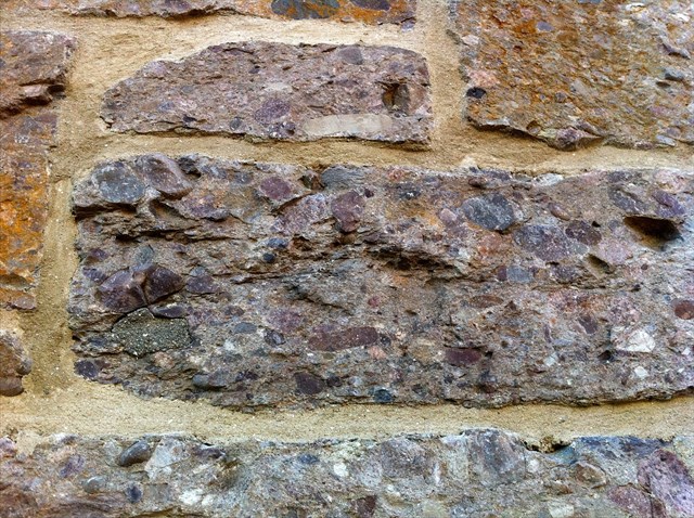
The types of clasts (rock 'plums') in Roxbury Puddingstone can vary (for reasons we'll explore in the future); however, quite simply, they tend to be a mix of igneous and metamorphic rock (see glossary), such as: quartzite (opaque white), granodiorite (pinkish), basalt (black) and other "felsic" (silica-rich) rock, each rock type telling a story about the setting from which it originally came, such as from a volcano, long ago and far away.
“Rocks are records of events.... They are books. They have a different vocabulary, a different alphabet, but you learn how to read them.” - John McPhee
And what are the ingredients of the surrounding 'pudding'? This matrix is a feldspar-rich ("arkosic") sandstone held together by its own cement (silica), one key to Roxbury Puddingstone's superior strength and water-resistance (handy for New England weather). In the future, we'll look more deeply at the science and story of the individual clasts and matrix but, for now, let's pause a moment to apply what, so far, we've only talked about:
Take a closer look at some of the blocks of puddingstone forming Old South Church. Explore the individual clasts, finding not only the numbers of rocks in the conglomerate but noticing also the different kinds of rock contained. Something else you might notice are familiar-looking stains produced when iron found in some of the clasts endured prolonged exposure to water and weather. See any evidence?
In addition to its unique beauty, Roxbury Puddingstone has much to offer structurally, too - including, as previously noted, superior strength and water-tightness. In fact, compared to most other conglomerate stone, Roxbury Conglomerate is far superior in this way, other conglomerates being prone to breakage.

Other stones and metals, too...
For all its construction benefits, puddingstone also presented certain challenges for the mason - because of its pebbly texture, for example. To ponder this problem and discover its architectural solutions, let's step back and admire the whole of Old South Church, taking in as many of the various kinds of building stones and metals as we can and, from that vantage point, consider the structure now both for its architectural beauty and the unique qualities each stone and metal contributes towards making this architectural vision a reality.
Old South Church is a bit like Roxbury Puddingstone itself, then: composed of five or so plums (the stones and metals) unified in a matrix that is its architectural design. The building materials include: puddingstone, granite, slate (two colors), copper, iron and sandstone (two colors) - each with aesthetic and structural qualities chosen to best bring to life the spiritual vision of hope and progress Old South's congregation sought to establish. (While you're exploring the different stones and metals, see if you also can spot the variety of birds and animals almost hidden in the midst of the intricately carved border found on the Dartmouth Street side and elsewhere on the church. Truly enchanting, offering a clue about the stone from which these carvings are made and not to be missed!)
In summary, do a little checking, exploring further the natures of each additional stone and metal and, from those discoveries, try to solve the puzzle posed above: How do the qualities inherent in each stone and metal serve or preempt specific uses? To further the quest, this puzzle is repeated in the logging questions below, along with some help from a hint.
Before we move on, look skyward. You cannot miss the campanile (bell tower), with its combination of beautiful stone and metal work and its 2,020 pound bell! In fact, this is the second campanile for Old South, this one built in the 1930's to replace the original tower after it began to noticeably lean in the 1920's. But what happened? Here Old South's history and the history of the land beneath it interweave for a second time, the first being when the newly developed dry Back Bay offered the church a spacious place to stand.
The Back Bay
To get us oriented, please find Dartmouth St. on the map below (running roughly north/south in line with the western most oval marker for Route 9). Next, find Boylston St. (running roughly east/west just north of Route 9). Our Earthcache is situated in the area around this intersection of Boylston and Dartmouth, an area known as Copley Square and previously under water. Here now stand the two structures we are exploring and where next we'll tune into the earth changes this area experienced. What did it look like when it was a tidal bay? What did it feel like? How do these buildings manage to stand? In what ways does the stone that forms them daringly test this unlikely building spot? (Trinity Church tower alone weights 90 million pounds.)
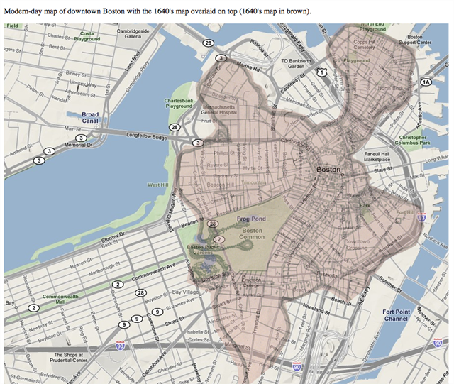
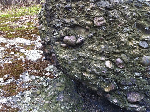
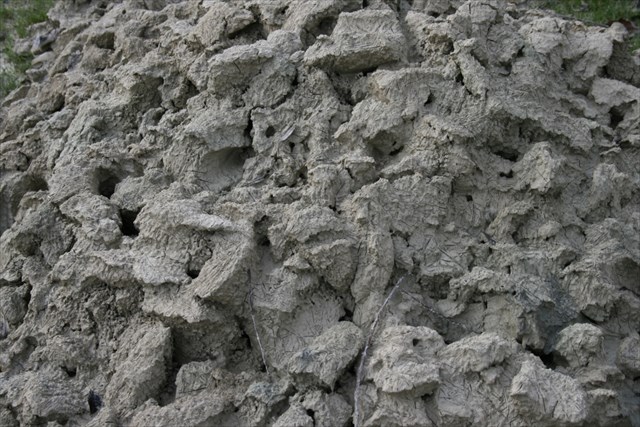
Broadening our vista, and as the map clearly illustrates, we see not only Copley Square was under water in the early 19th century (and long before). Less than one quarter of the earth in downtown Boston is original land; the rest is fill. And even in the case of the original land area, it was not the most solid ground. That area is essentially hundreds of feet of clay, gravel and sand left behind by the glaciers. These variables taken together (the Back Bay's being fill and the original land's being gravel, sand and clay) have posed a significant challenge to architects and engineers. Compounding the problem, the deep layer of Boston Blue Clay (see glossary) that lies beneath the fill is very soft and spongy (see also photo of glacial clay, similar to Boston Blue Clay, below). Imagine designing a building that would be structurally sound enough and wouldn't sink? Not so simple, as the original Old South bell tower demonstrated. Faulty footings and piles driven into the soft, spongy clay were the cause of the tower's listing, it's believed.
Further traveling back in time: how and why did the Back Bay become land in the first place? The short answer is that a combination of industrial and housing needs coinciding with significant human error caused an inescapable need. After millions of years of nature's carving the coastal landscape (as we discussed in part in "Plums in the Pudding I"), Boston underwent another dramatic change, this time at the hands of humans. Here's what happened:
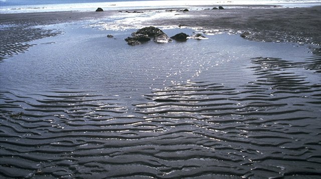
At the time the first European settlers came to Boston in the 1600's, the Back Bay was a tidal bay. To help imagine the vista: at low tide, it must have looked like a very large expanse of wet, rippled mud, similar to how other tidal bays look today (see photo of a tidal flat below). At high tide, the same area was under water. Further, because the Back Bay (then) was an "estuary," where the freshwater of the Charles River and the sea water of the ocean met, the direction of flow changed with the tides; estuaries are governed by tides. (Fittingly, "estuary" is derived from the Latin "aestus" and means "tide.")
For a considerable period of time, Bostonians used this tidal movement like a big flush toilet, dumping not only garbage but also raw sewage into the bay where it would be carried out (for the most part) with the tides. (In fairness to the Bostonians living then, this was a common practice.)
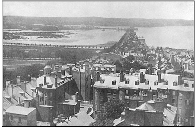
At the same time, the population of Boston was growing and the development of industry begged new and better ways to generate power. The Mill Dam Project was launched in 1818 in an attempt to harness the movement of the tides for energy production purposes (see photo of the dam and water, viewed from the State House on Beacon Hill).*** Unfortunately, the project failed. Compounding the problem, damming the Back Bay broke the tidal toilet. The garbage and sewage no longer washed out to sea and, instead, began to grow in size, stench, vermin and health threat. To better appreciate what we can no longer see, let's pause again and travel back in time, tuning in to the scene and human story:
What's it like living in Boston during the height of this problem? What are the sights, smells, moods, conversations? Listening in (at the dinner table, the tavern, the park, the work place, town meetings), what's on everyone's mind? The growing in-your-face problem must have been a preoccupation with everyone. And given the science and technology at their disposal, how would they determine and implement their options? Adding to the conundrum, what trepidation did Bostonians feel when considering a massive new project so relatively soon after the dramatic failure of the Mill Dam Project? In a way, they had a puddingstone-like situation on their hands: a tumultuous condition of mud and rubble (refuse in their case) begging to evolve into something solid, stable and beautiful.
Although it took a few more years to overcome land and planning obstacles, the process undoubtedly was hastened when the Commonwealth threatened to take the land under public health threat. At that point, businesses and the city government came to an agreement and decided on a plan. Filling the Back Bay became the solution to the growing garbage problem and the growing housing need.
The fill for the project came primarily from Needham, where, thanks to the glacial deposits in that location, there was ample, inexpensive gravel to serve the purpose. So, special train lines (and railroad cars) were built to deliver the gravel to the Back Bay. (Of further historical interest, part of the current MBTA Green Line still roughly follows that route.) Reportedly, to create the 580 acres of current Back Bay land, nine filled train cars deposited gravel every 45 minutes, day and night, for almost fifty years, making this one of America's most ambitious public works projects.
Arguably, and despite other problems that were created and needed solving (e.g., in the South End), the project worked. Spanning the esplanade to the South End, the Public Garden to Kenmore and the Fens, with its residences, offices, businesses, museums, schools, churches (many built of the very puddingstone that brought us to this place) and green spaces, the Back Bay is now a beautiful and orderly urban area. The once back bay tidal marsh became the now Back Bay land, visually unrecognizable from what it was a little over a century ago, yet perhaps not unfeelable… with a little tuning in… and a little dreaming.
In the midst of Boston city
In the midst of Boston City
A history lay
The birds to preach on a wire
And squirrels at mooring play
makes for a calm day.
- David E. Patton
Glossary
BOSTON BLUE CLAY - Thick layer of "rock flour" under Boston Harbor and parts of Boston, formed from the lighter materials, rock dust and clay carried by retreating glaciers toward the ocean.
GRANITE – A common, medium-coarse grained, intrusive igneous rock.
IGNEOUS ROCK – Formed by the cooling of magma or the accumulation of materials ejected from volcanoes. Intrusive igneous rocks cool slowly within the Earth while extrusive igneous rocks cool when erupted onto Earth’s surface.
METAMORPHIC ROCK – Created when previously formed rocks undergo intense heat and pressure, making them more compact and banded.
MINERAL – A naturally occurring, non-living crystalline solid with a defined chemical composition and defined physical properties.
QUARTZITE - A hard metamorphic rock, originally sandstone, which is converted into quartzite through heating and pressure.
ROCK – Composed of minerals and classified into three groups (igneous, metamorphic, and sedimentary) based on their formation and composition.
SANDSTONE - is a sedimentary rock composed mainly of sand-sized minerals of rock grains. Most sandstone is composed of quartz and/or feldspar.
SEDIMENTARY ROCK – Formed when sediments (fragments of rock, silt, sand, and clay) accumulate and are compacted and cemented into rock.
Logging Requirements
Note: Please do not post answers in logs. Please send your answers in a private message.
Also, note: All questions apply to outdoor/exterior spaces only.
1. Old South Church is built from Roxbury Puddingstone, slate (two colors), granite, sandstone (two colors), iron and copper. Where on the building *exterior* can each be found and what quality of each do you think made it most suitable for that specific purpose?
2. Puddingstone and sandstone are both sedimentary rocks. What is the evidence of this sameness? How are they different?
3. True or false. The matrix in the Roxbury Puddingstone found in Old South is primarily iron oxide.
4. True or false. "Tidal bay" is a colloquial expression (and literal contradiction) and has nothing to do with the influence of ocean tides.
5. True or false. A failed dam and a growing garbage/refuse problem played an important role in the history of the current Back Bay.
6. Stand in Copley Square (see waypoint) in the area before Trinity Church. What material is immediately beneath your feet? Now, mentally travel down through this and its foundational layers to the layer of Back Bay fill. What kind of stone is this? Next, travel down farther, well into a thick spongy layer. What is that soft, spongy material? What is it called? (Suggested but optional: While you're down there, project your vision through the mass to the foundations of Trinity Church and the John Hancock Tower. Granite and four thousand cedar piles form Trinity's original and current foundation. Advances in engineering and manufacturing created other options for the Hancock. What do you think you might see over there?)
7. (Optional) Find one or more other puddingstone churches in the Back Bay and name two relevant (to this Earthcache) features of your discoveries.
8. (Optional) What, if anything, from this experience deepened your understanding of and appreciation for Roxbury Puddingstone specifically and Boston's earth science history generally?
9. (Optional) Feel free to post photos but please no spoilers!
P.S. There are other caches nearby and throughout the Back Bay!
Notes and References
*Earthcache Series Title: The expression "plums in the pudding" was offered by Oliver Wendell Holmes Sr., endearingly translating the original inspiration for puddingstone's name, its similarly to Christmas pudding.
**The Back Bay is not in Roxbury Puddingstone territory (as such); the Roxbury is not the uppermost bedrock here. Cambridge Argillite is (although the Roxbury appears to lie beneath at least part of the Cambridge Argillite in this area).
***Photo showing Mill Dam Project and water: Viewed from the State House, the dam is seen on the right from around Charles St. stretching to Brookline along what is now Beacon St.; the shoreline visible to the left of the dam marked the edge of the Public Garden.
Conglomerates:
University of Auckland, http://flexiblelearning.auckland.ac.nz/rocks_minerals/rocks/conglomerate.html
Puddingstone:
Dr. Jack Share - personal communications and blog, http://written-in-stone-seen-through-my-lens.blogspot.com/2011/03/architectural-geology-of-boston-roxbury_27.html
Old South Church:
http://www.oldsouth.org/about/history
http://www.iboston.org/mcp.php?pid=newOldSouthChurch
Trinity Church:
http://www.trinitychurchboston.org/architecture.html
http://www.iboston.org/mcp.php?pid=trinityChurch
Glossary:
Museum of Science rock garden exhibit and publication: http://www.mos.org/media/docs/MOS_Rock_Garden_Map.pdf
bostongeology.com
carefully reviewed individual Wikipedia pages.
Geology and Development of Boston:
Boston Geology - history, map, photos of glacial clay and Mill Dam Project: bostongeology.com
Boston History and Architecture - iboston.org
Environmental Engineering Geologists - http://www.aegne.org/geology_of_massachusetts.htm
Tidal flat photo:
Marli Bryant Miller, Geology and Earth Science Images, http://marlimillerphoto.com/images.html
Back Bay Soil Profiles image:
W.A. Newman & W.E. Holton, "Boston's Back Bay," Northeastern University Press, 2006.
All other photos:
foragess
| I have earned GSA's highest level: |
 |
Congratulations to yervel for being FTF (first to meet logging requirements)!
The Historic Boston GeoTour
