Steenberg Rock Shelter
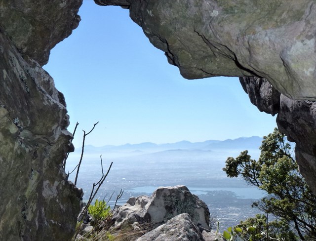
The cache is hidden in a large triangular rock shelter about 200m SW below the top of the 504m Lower Steenberg Peak (LSP) in the northeast corner of the east Silvermine section of Table Mountain National Park. It would be a welcome place to shelter/rest if you got caught out in bad conditions and (in good conditions!) has a fine view east through one of its windows. It is located just off the trail heading up to LSP summit from the S 34 5.901 E 18 27.047 junction with the jeep track near one corner of the communications mast fence.
There are also 2 caches up on the summit – Raymond E’s 2002 Virtual Cache GC51A0 Lightning Conductor? and SawaSawa’s 2012 GC3G7KW Lower Steenberg Peak cache – so you may have at least 3 reasons to make the effort to get up here!
The cache, a small camo-taped tablet pot with a few small tradable items, is hidden under a small rock pile at the end of a short side passage in the shelter.
Note: the terrain rating applies to route option 1) Steenberg Buttress, by other routes it is only 3.5!

To reach the cache:
There are many ways to get there including these four:
1. From the northern end of Boyes Drive via the highly recommended and entertaining Steenberg Buttress route*, capeccr’s fine cache Steenberg Igloo GC2K31R and the summit of Lower Steenberg Peak (LSP). Park @ S 34 5.216 E 18 27.019 *as described in Karen Watkin’s ‘Off the Beaten Track’.
Some additional notes on this route which is mostly fairly obvious and generally pretty well marked with cairns – especially if you find yourself in cloud: When you reach the top of the buttress, the easiest way to reach the nearby summit and cache location is to follow the ridge south and then pick up the line of the old cable pipe which you will find around S 34 5.636 E 18 26.829.
Waypoints for Descent from LSP Summit: When leaving the summit head SW along the ridge and then down a little towards S 34 5.666 E 18 26.859 where you will pick up a faint trail heading down and on to S 34 5.680 E 18 26.864. Continue heading down SW through a rock corridor and past the large rock shelter (location of this cache) and further down to where you will meet a distinct trail @ S 34 5.730 E 18 26.947. Follow this down to meet the jeep track by the corner of the communications mast fence @ S 34 5.901 E18 27.047. From there the trails are distinct and most junctions well marked.
2. From Muizenberg Centre / Boyes Drive above Surfer’s Corner via Farmer Peck’s Valley (and the ‘endless stone steps’!) Park @ or near S 34 6.416 E 18 27.991, head up the steps at the top of the road to Boyes Drive then walk about 60m south to the starting gateway to the mountain.
3. From Boyes Drive above Zandvlei passing east of Rooikrantz. Park @ S 34 5.603 E 18 27.550.
4. From Silvermine East Gate via Wolfkop Steps and Higher Muizenberg Peak (or other routes). Park anywhere in the large parking area – if you park @ S 34 5.456 E 18 25.282 (the most eastern spot) take the trail heading east out of the parking area which joins the main jeep track heading south after around 150m just opposite the start of the trail to Wolfkop Steps and up onto the mountain.
For options 2) 3) and 4): Make your way to waypoint W5 then follow the Waypoints for Descent from LSP Summit in reverse, ie. W4 – W3 – W2 – LSP cache or Lightning Conductor? cache.
Enjoy the trails and (weather permitting) great views!