St. Andrew's Lock and Dam "Lockport Bridge" Traditional Cache
St. Andrew's Lock and Dam "Lockport Bridge"
-
Difficulty:
-

-
Terrain:
-

Size:  (micro)
Please note Use of geocaching.com services is subject to the terms and conditions
in our disclaimer.
In 1910, it took a lot of men to slow this river down...
St. Andrew's Lock and Dam was constructed to raise water levels downstream and eliminate the series of rapids that began just North of Middlechurch and ended at the St. Andrew's rapids, thus making the river navigable.
The Lockport Bridge is 788 feet long, supported by eight piers, and has a fishway, a Camere dam, and a lock.
The Camere or curtain style dam at Lockport Bridge is the only structure of its kind in North America, one of only four in the world, and is the largest Camere dam ever constructed. Each of its 90 curtains are made of 50 Douglas-fir laths which can be raised or lowered on very short notice depending on water levels which can fluctuate as much as 8 feet due to atmospheric and wind conditions on Lake Winnipeg. The raising of these curtains also allows for the passage of ice during spring break up.
The locks are 215 feet long, 45 feet wide, and have a depth of 22 feet. The lock gates are 13 feet high and when the gates were replaced in 1984, a special search had to be made for a certain density of Douglas-fir. This timber was located in forest near Seattle. The locks can be filled or emptied in six minutes by automatic self-balancing valves thereby allowing boats to be lowered to the water levels on the South side of the locks and raised on the way to the North side.
The construction of St. Andrew's Lock and Dam in Lockport began in 1900 and was completed in 1910. The main bridge and lock were completed at a cost of $3.5M with workers making between 15 and 25 cents per hour. The first vessel to pass through the locks was a government boat named “Victoria” on May 2, 1910. The St. Andrew’s Locks were officially declared open on July 14, 1910 by the Prime Minister of Canada, Sir Wilfred Laurier.
In 1913, the bridge was paved to allow for automobile and foot traffic, and a fishway was constructed at the East end of the bridge. A bascule lift or drawbridge was later added to allow tall ships to pass through the locks, but in the 1990s when the bridge underwent major reconstruction, the bascule lift was replaced with the fixed section you see at the West end of the bridge.
There is parking available at either end of the bridge and the cache is closer to the center of the bridge, so there is no short way to the cache. I did this so you can enjoy your walk to the cache, the sound of the falls roaring beneath you, and the view at the top of the bridge. Please pick a warm sunny day to find this cache, so you get the full enjoyment of this engineering marvel which was named a National Historic Site and a Canadian Civil Engineering Historic Site.
Bring your camera!
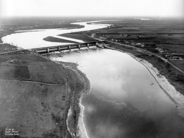
St. Andrew’s Lock and Dam 1923
Notice in the photo that the bridge approach on the West (right side) turns down onto River Road and does not proceed straight as it does now.

Additional Hints
(Decrypt)
Zntargvp