Knobs
In Kentucky, the "Knobs" are the erosional remnants of the Pottsville Escarpment on the east and Muldraughs Hill on the south and west of the Bluegrass region. This region lies in a narrow belt 10 to 15 mi wide and marks the outer limit of the Bluegrass region. Elsewhere, other knobs occur along the outer margins of the Cumberland and Mississippian Plateaus and in front of the Dripping Springs Escarpment. Individual knobs are characterized by symmetrical concave-upward slopes which rise gently out of the bottomlands or surrounding plains. The slopes steepen upward into cliffs on knobs with resistant caprocks. Knobs that have lost their protective caps have rounded crests. Well-developed knobs may be nearly circular or elliptical in plan view.
Figure 1: Escarpments form when the uplands become isolated from the developing valley.
Figure 2: Knobs in the various stages of development, from flat-topped portions of the upland recently isolated from the main area, to typical conical knobs, earlier isolated and with the cap rock gone.
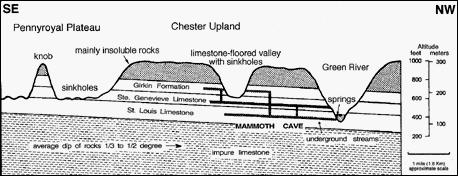 Figure 3: Cross-section of Pennyroyal Region and Dripping Spring Escarpment
Pilot Rock
Pilot Rock is the highest point in both Christian and Todd Counties with an elevation of 966 feet. Big Clifty Sandstone is the underlying rock of the Dripping Spring Escarpment. It can be seen at Pilot Rock and on top of other high knobs in Kentucky as well as the cap-stone (top) of Mammoth Cave.
History
Pilot Rock is a local landmark in eastern Christian and western Todd Counties. Since the early 1800's local citizens would come to the crag and climb to its summit without much difficulty. Once there one has splendid views of the surrounding country for many miles. During the fall and winter , Hopkinsville, twelve miles away, can be seen from the summit. It was even said on the clearest of days, one could see, with a 'spy' glass, the steam boats on the Ohio River some 60 miles to the north and north west.
Pilot Rock's listing on the National Register of Historical Places states that Woodland Indians painted petroglyphs on the rock (or somewhere in the immediate area) and used it as a ceremonial site. However, these are hard to find. The location is very popular, and over the years, they may have been vandalized or covered by painted grafitti.
Legend has told that a bag with three thousand dollars worth of gold coins is buried in the area around Pilot Rock. It is believed that the gold was from the sale of tobbacco by a local farmer. As the farmer and his party made their way home, they were ambushed. Some of the group eluded the robbers and buried the gold. They planned to retrieve it later, but they could never locate it again.
Geology
The Dripping Spring Escarpment is a conspicuous high plateau that rises about two hundred feet above the lower sinkhole-filled plain of the Pennyroyal regions of Kentucky. The Mississippian (or Pennyroyal) Plateau of south-central and western Kentucky is an upland region underlain by Mississippian rocks, mostly limestones. To the north is the Western Coal Field region, a hilly upland of low to moderately high relief filled with Pennsylvanian sandstones, shales, and coal beds. The Dripping Spring Escarpment is capped by the Big Clifty Sandstone, also known as Cyrpus sandstone or Middle Chester sandstone. It is this hard sandstone caprock which protects the underlying limestone from active destruction by weathering processes. The Big Clifty Sandstone is of the Pennsylvania Age. It is named for Big Clifty Creek located to the south of Elizabethtown, Kentucky.
There are several lesser knobs of note near Pilot Rock. These include: Pine Knob a few miles west of Pilot Rock: (863 feet), Keeling Hill in Todd County near Fairview (848 feet) and Tucker Ridge a few miles north/northeast of Pilot Rock: (880 feet). The area to the east of Marion, Kentucky has several individual knobs that have formed along the Dripping Spring Escarpment near the Tradewater River.
 Sandstone is a sedimentary rock composed varying sizes of fragments of quartz and/or feldspar - the most common minerals in the Earth's crust. Sandstone may be composed of coarse clastic (fragments), fine clastic, and nonclastic rocks. The sandstone can range from thinly stratified fine-grained "muddy" sandstones to cross-stratified medium-grained sandstones to nonstratified. Coloration varies from light (quartz) to grays (calcite) to black (pyrite) to red (hematite), but the most common colors are tan, brown, yellow, red, gray and white. Certain colors of sandstone have been strongly identified with certain regions.
IN ORDER TO LOG THIS FIND YOU MUST:
A. Click on my profile and e-mail the answers for the following tasks. Do not post your answers when you log in your find. Logs which do not meet the requirements to claim the find will be deleted.
1. What color is the Big Clifty Sandstone in this region of Kentucky? How does this color compare to the rock layer near the parking area?
2. Describe the feeling of the sandstone when you touch the blocks. Is the sanstone coarse clastic, fine clastic, or non clastic?
3. Look closely at the sandstone. Is there evidence of stratification? If so, are they thinly stratified, cross-stratified, or nonstratified?
4. Desribe, in detail, what evidence you see that some layers are more resistant than other layers. Where does this layer(s) lie in relation to the other layers?
B. (Optional, though greatly appreciated) Take and log a picture of you (and your group) standing near Pilot Rock.