Cattle Point Earthcache
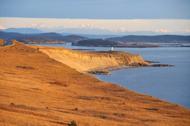
The southern tip of San Juan Island is known as Cattle Point. Situated on a sandy bluff at the entrance to Cattle Pass and the San Juan Channel, between San Juan and Lopez Islands, the interpretive area and trails at Cattle Point provide a breathtaking land and seascape in a harsh environment. To get to Cattle Point you will travel through American Camp National Historic Park. The Cattle Point Lighthouse sits at the tip of Cattle Point, at the entrance to Cattle Pass. This public land to the east of American Camp is known as the Cattle Point Natural Resources Conservation Area.
The Geologic History of Cattle Point
The impact of this region’s glacial history are still clearly visible at Cattle Point. Mt. Finlayson and the bluffs along South Beach are a glacial moraine comprised of outwash sand and clays. The moraine along South Beach varies in height between 30 – 100 feet. The American Camp and Cattle Point area is covered with quaternary alluvium and glacial deposits. As you walk along the beaches of this area, you can see evidence of glacial striations (grooves etched, scratched, or scraped into the bedrock).
The San Juan Islands were directly in the path of the Pleistocene glaciers that formed and advanced south from British Columbia. The Fraser glaciation, 18,500 to 10,000 years ago, was the last in this area. During the Fraser period this area was covered by glacial ice up to a mile thick. The powerful eroding force of the glaciers smoothed and rounded the landscape of the islands and deepened the channels that ran parallel to the southward glacial advance. Because the islands are composed of more resilient rocks than those found below the waters of the straights, the islands resisted erosion while the channels around the islands, such as the Strait of Juan de Fuca between the San Juan Islands, Vancouver Island and the Olympic Peninsula, were carved deeper by the glaciers.
As the Fraser glacier melted starting about 15,000 years ago, it deposited materials on San Juan Island. At Cattle Point you can see many glacial erratics, large rocks and boulders picked up by the ice flows and left behind as the glacier moved through this area and melted. Some granite erratics on San Juan Island traveled 200-300 miles from the north.
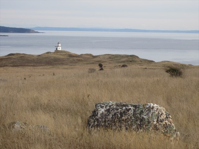
Glacial erratics at Cattle Point
After glaciation, sea levels in this area initially rose to 500 feet higher than they are today as water formerly locked in the glacial ice returned to the sea. The sea levels also appeared higher because the land was compressed by the immense weight of the glaciers. As the ice melted, the tremendous weight on the land was removed and the land began to slowly rebound (rise). This is called isostatic rebound. Although sea levels rose with the glacial melt, the rate of resulting land mass rise in this area was even greater, and this process of isostatic rebound formed a succession of former beaches that today are viewed as terraces on the slopes of Mt. Finlayson. Each step of Mt. Finlayson’s glacial terraces indicates a former seashore as the island rose via isostatic rebound when the mile-high glacier melted. Isostatic rebound slowed considerably in this area 6,600 years ago. By 5,000 years ago, eustatic rebound (worldwide sea level) leveled off to a point where sea levels across the globe stabilized to their present levels.
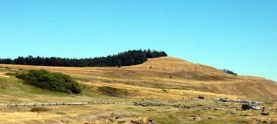
Glacial terraces at Mt. Finlayson
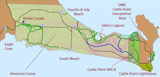
Parking is available at the Cattle Point Interpretive Center near a picnic shelter housed in an old powerhouse, leftover from an old Naval Radio Compass Station. A short walk back along the road brings you to the start of the trail leading to the point and the lighthouse. Please note that this parking lot now requires a Washington State Parks Discovery Pass. There are also a few places to pull off the road and park along Cattle Point Road before reaching the trailhead and interpretive center, but be sure to enter the trail at the official starting GPS coordinates to find all of the educational features and trail signs that will teach you about Cattle Point. font>
Claiming this Earthcache:
To claim the Cattle Point Earthcache you will need to take a short walk out to this scenic south tip of San Juan Island. The trail is an easy 0.5 miles total (out and back) with minimal elevation gain. While this short hike is driest in the spring through fall, being at Cattle Point during a winter storm can be beautiful and dramatic, if you’re properly attired!
Email the cache owner your answers to the questions below. The answers to the questions can be found by reading the signs along the interpretive trail and observing the environment around you. If emails are not received or are incomplete, your log will be deleted from the website.
Questions for Cattle Point Earthcache:
1. Look for glacial erratics in this area. Describe one and estimate where you think it came from originally.
2. Look at the glacial terraces on Mt. Finlayson. Over what time period (how many years ago) do you think they were formed?
Cattle Point Earthcache was created in honor of the 2nd San Juan Island Geocaching Adventure in 2011, and is dedicated to our Canadian geocaching friend, KiwiBirdMan.
If you have your camera with you (and you should, it is beautiful at this end of the island), post a photo of yourself at the point with the lighthouse in the background.
References, web links and further information on the Cattle Point area:
San Juan Island National Historic Park link: http://www.nps.gov/sajh/
Geologic Formations at American Camp: http://www.nps.sajh/naturescience/geologicformations.htm
Glaciers/Glacial Features at American Camp: http://www.nps.sajh/naturescience/glaciers.htm
San Juan Islands Trails Committee: http://sanjuanislandtrails.org/trails/american-camp/cattle-point.html