These are somewhat resistant bits of the Dakota Sandstone. The sandstone in this area has irregular areas that are more heavily cemented, and other areas that aren't as well cemented. The more resistant stuff doesn't erode as quickly, and thus forms all these cute little mini-buttes.
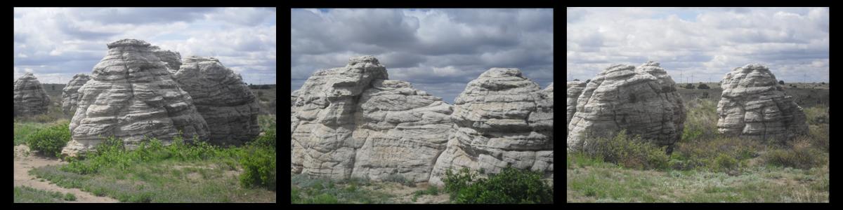
"The Dakota Formation consists of interlayered siltstone, shale, and sandstone with local conglomerate beds. This formation is extremely widespread across the Great Plains from the Dakotas southward into New Mexico. It extends over broad areas of southeastern Colorado, and crops out in the Smoky Hills physiographic region of Kansas (Aber and Aber 2009). The geomorphic expression of the Dakota Formation is controlled by its lithology. Sandstone and conglomerate bodies are distributed in various lenses, channels, and sheets, and local cementation is highly variable. Well-cemented sandstone and conglomerate are more resistant to erosion than are other poorly consolidated strata and, so, form higher knobs, ridges and buttes where they are present.
The patchy distribution of cemented zones within sandstone and conglomerate bodies explains the irregular size, shape, and placement of hills (Aber and Aber 2009). Where poorly consolidated, on the other hand, the Dakota tends to erode easily and is a source for loose sand that may be transported by water or blown locally into dunes."
The Dakota Formation is one of the most widespread geologic units in Colorado.. It consists of sands, silts, and other sediments from the shallow sea that covered Colorado in the Cretaceous Period. In eastern Colorado, it is more resistant to erosion than other rocks in the region, and thus it tends to form many of the local bluffs, ledges, cliffs, and canyons in the Arkansas River Valley near Lamar.
Even within the Dakota Formation, some areas are more resistant to erosion than others. Some lenses and beds are well-cemented. Others are not as well consolidated and thus have eroded away. It is quite variable, even on a
fairly small scale. Sandstones and conglomerates that are well-cemented resist erosion better, and thus form the higher knobs, ridges, and buttes in the region.
One place where this can be seen on a very small scale is at the Gobbler's Knob Rest area. Look around at the fantastical toadstool-like outcrops. These are known locally as the Bee Hives. They are small outcrops of Dakota Sandstone, demonstrating the very localized resistance to erosion.
To log this cache, please answer the following in a private message to
the cache owner...
Estimate the height of the Bee Hives?
Are they all the same height or different?
Why do you think that might be?
Walk up to the outcrop and rub your hand on it. Does sand come off easily?
How does this compare to the sand/dirt beneath your feet?
Are some parts of the outcrop harder than others?
(With all new Earthcache, all photos are optional)
Special Thanks to jp66 for her help with this Earthcache!