Be smart, be an EarthCacher - geology rulez! ;)
)")
Credits: Leibniz-Institut für Ostseeforschung Warnemünde, PGI-PIB: dr hab. Szymon Uścinowicz, naszbaltyk.pl, NASA

Earthcaches z serii "Mare Balticum" - będzie ich więcej - dedykuję założycielkom i założycielom keszy w Trójmieście i okolicy. Dzięki Wam podczas majówki i w sierpniu 2012 miałem przyjemność zdobyć około 100 Waszych skrzynek. Dziękuję za niezapomnianą zabawę!
Opis: Bałtyk jest jednym z najmłodszych mórz Ziemi. W ciągu ostatniego miliona lat obszar północnej Europy kilkakrotnie pokrywały lądolody. W trakcie każdego nasunięcia lądolodu powierzchnia ziemi była intensywnie formowana. W rezultacie powstało rozległe obniżenie w skorupie ziemskiej, zajmowane obecnie przez Bałtyk. Względne różnice między tempem podnoszenia się Skandynawii, a tempem wzrostu poziomu oceanu swiatowego, są głównym czynnikiem rozwoju Bałtyku. W ciągu swojej historii, morze przeszło kilka wyraźnych faz rozwojowych. Okresowo odizolowane od oceanu było zbiornikiem słodkowodnym, by po uzyskaniu połączenia, przekształcać się w typowe morze wewnątrzkontynentalne.
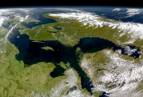
Algal bloom on the Baltic Sea / photo: NASA
Bałtyk dziś... i jutro
To że Bałtyk geologicznie dalej się zmienia i będzie się zmieniał, wiadomo nie od dzisiaj. Człowiek na te zmiany nie będzie miał ani wpływu, ani nie będzie się im mógł specjalnie przeciwwstawić. Dno północnej części akwenu wypiętrzy się, podczas gdy południowa część zostanie obniżona. Południowe wybrzeża będą coraz bardziej poddane erozji, przez co morze wtargnie w głąb lądu. Natomiast na północy - z dużym prawdopodobieństwem w czasie przyszłej epoki geologicznej - wybrzeże podniesie się o około 50 m. Przypuszczalnie proces ten odetnie Zatokę Botnicką od reszty Bałtyku: z czasem stanie się ona jeziorem słodkowodnym.
Jak wyglądać będą najbliższe zmiany geologiczne Bałtyku, można zaobserwować pod koordynatami, na których stoisz: u stóp Klifu Orłowskiego, stromego brzegu morskiego należącego do Kępy Redłowskiej. Klif ten jest najbardziej znanym klifem polskiego wybrzeża. Duża zmienność jego ściany po okresach sztormów i widoczne zaburzenia glacitektoniczne czynią ten obiekt niezwykle atrakcyjnym, tak dla osób związanych z geologią jak i dla turystów czy... "łowców earthcaches".
Najbardziej spektakularną częścią klifu są obrywy - przed którymi stoisz - wielkie "bloki", osunięte w dół, zbudowane z gliny zwałowej: skały ilastej, powstałej z błota morenowego, którą osadził tu lądolód skandynawski. Klif Orłowski zalicza się do tych 55% polskiego wybrzeża, które podlegają procesom intensywnego niszczenia. Prognoza zmian w strefie brzegowej potwierdza długoterminowe prognozy geologów: wskazuje na stałe narastanie procesów abrazji (jeden z procesów erozyjnych zachodzący m.in. na stromych wybrzeżach).
Bonus: u stóp klifu można często znaleźć wypłukane z niego skamieniałości(!)
Odpowiedzi proszę wysyłać za pomocą mojego profilu. Nie trzeba czekać na odpowiedź, można od razu logować. Jeśli odpowiedź będzie niepoprawna, zgłoszę się sam. Pamiętajcie proszę, że logi bez podesłanych odpowiedzi będą kasowane.
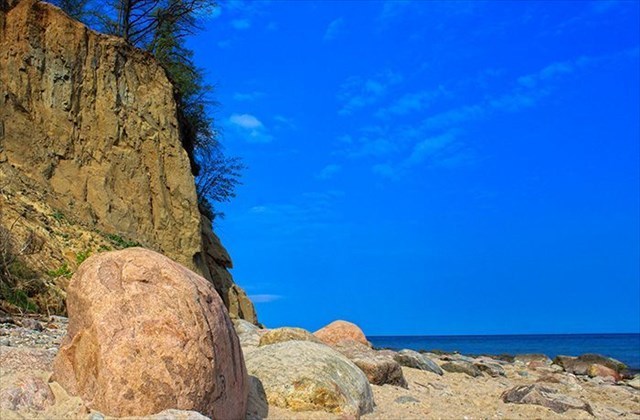

Orłowski Cliff / photo & background photos: Hanbei
ZADANIA:
- Pod koordynatami kesza stoisz przed Klifem Orłowskim przy dużym otoczaku (zdjęcie). Czy jest to skała magmowa czy metamorficzna? Podaj - w centymetrach - obwód głazu.
- Dlaczego odcinek wybrzeża, na którym stoisz, jest wybrzeżem aktywnym?
- Pod klifem leży duża ilość potężnych głazów narzutowych. Skąd się tu wzięły?
- Z jaką szybkością obniżają się obecnie południowo-zachodnie wybrzeża Bałtyku, a z jaką wypiętrza dno części północno-wschodniej?
- Gdzie leży linia graniczna, tzw. zerowa pomiędzy wypiętrzającym się dnem a osuwającymi się wybrzeżami bałtyckimi?
- Zadanie opcjonalne: tu naprawdę warto zrobić jakieś pamiątkowe zdjęcie ;)

Die Mare-Balticum-Earthcaches - ein paar davon folgen noch - widme ich allen Cacherinnen und Cachern der Dreistadt/Trzëgard (Danzig/Zoppot/Gdingen). Im Mai und August 2012 hatte ich die Freude, knapp 100 Caches in eurer Region zu finden. Das Vergnügen war ganz auf meiner Seite. Somit gilt euch mein höchster Dank & Lob!
Beschreibung: Die Ostsee ist eines der jüngsten Meere unseres Planeten. Innerhalb der letzten Million Jahre wurde Nordeuropa mehrmals von einem Eisschild bedeckt. Die Ostsee entstand am Ende der letzten Eiszeit - der Weichseleiszeit - vor etwa 12.000 Jahren, nach dem Abschmelzen der skandinavischen Gletschermassen. Ihre heutige Gestalt und Eigenart bildete sich über mehrere Etappen durch ein Zusammenspiel von Landhebung und Meeresspiegelanstieg. Innerhalb dieser Zeit unterlief das Meer mehrere Entwicklungsstadien. Stellenweise, isoliert vom Weltmeer, wurde es zum Süßwassersee, dann wieder wurde es brackig, anschließend salzig und brackig-salzig. Letztendlich wurde es zu einem typischen Binnenmeer.
Ostsee heute... und Morgen
Geologische Evolution der Ostsee ist selbstverständlich nicht abgeschlossen. Dieses Meer verändert sich nicht nur jetzt, es wird auch in Zukunft dem geologischen Wandel unterworfen sein. Im Süden werden die Kliffküsten erodieren, das Meer wird ins Land eindringen. Im Nordosten wird sich der Meeresboden innerhalb der nächsten - zukünftigen geologischen Epoche - um ca. 50 m heben. Dies schneidet wahrscheinlich den ganzen Bottnischen Meerbusen ab, der damit zu einem Süßwassersee wird.
Der Mensch wird in dieser Hinsicht kaum etwas dagegen ausrichten können. Doch gerade der Mensch bedeutet heute für die Ostsee die größte Gefahr. Dieses fragile Ökosystem wird permanent von den 9 Anrainerstaaten bedroht. Allen voran sorgt die "Überdüngung" durch Rückstände aus der Landwirtschaft für rasante Ausbreitung der sauerstoffarmen Zonen. Mittlerweile wurden über 200.000 km⊃2; zu lebensfeindlichen Gebieten erklärt. Hier kommen nur noch giftige anaerobe Bakterien vor.
Die kommenden geologischen Wandlungen der Ostsee sind am deutlichsten an den Südküsten des Meeres zu sehen. An den Koordinaten stehst du vor dem Orłowski Kliff, einem aktiven Küstenabschnitt, der zu Kępa Redłowska zählt. Es handel sich um den bekanntesten Kliff Polens. Am spektakulärsten in der Kliffwand sind die großen "Lehmblöcke", die aus Moränenschlamm entstanden und direkte Hinterlassenschaft des skandinavischen Eischildes sind. Orłowski Kliff gehört den 55% des polnischen Küstenabschnittes, der äußerst intensiv erodiert. Die geologischen Vorhersagen bestätigen den langzeitlichen Trend: die Küste wird hier weiterhin abgetragen, die Kliffs in einigen Jahrhunderten zerstört.
Bonus: Am Fuße des Kliffs sind immer wieder Versteinerungen zu finden, die aus der Wand ausgespült wurden(!)
Bitte, sendet eure Antworten mithilfe meines Profils. Ihr dürft direkt loggen, ohne meine Antwort abzuwarten. Sollten eure Antworten falsch sein, melde ich mich. Bitte denkt dran: Log-Einträge ohne die abgesandte richtige Antwort-E-Mail werden gelöscht.
AUFGABEN:
- An den Koordinaten stehst du vor dem Orłowski Kliff an einem großen Findling (Bild). Handelt es sich hierbei um ein metamorphes oder magmatisches Gestein? Nenne - in Zentimetern - den Umfang dieses Steines.
- Warum wird der Küstenabschnitt an dem du gerade stehst als aktiv bezeichnet?
- An der Kliffsbasis liegen sehr viele mächtige erratische Blöcke (Findlinge). Wo kommen die alle her?
- Mit welcher Geschwindigkeit pro Jahr senken sich die südwestlichen Küsten dieses Meeres? Mit welcher hebt sich wiederum der nordöstliche Teil?
- Wo liegt die sogenannte Null-Grenzlinie zwischen den beiden sich hebenden/senkenden Meeresbodenteilen?
- Optional: Es lohnt sich hier wirklich, ein Bild aufzunehmen ! ;)

Yuriko translates my earthcaches into English. You can ask her for help too ;) Yuriko, big thanks for your perfect support ;)
The Baltic Sea is one of the youngest seas on the Earth. Over the last one million years Northern Europe was covered by ice sheets several times. Intensive processes of the Earth's surface formation occurred during each of the glacier slidings. Consequently, a vast depression in the Earth's crust was formed, where the Baltic Sea is located nowadays.
Relative differences between the rate of Scandinavia's uplift and the rate of sea level rise are one of the main factors affecting the formation of the Baltic Sea. The sea has undergone several distinct phases. As it was temporarily blocked from the ocean, it used to be a freshwater reservoir. Later the connection was re-established and the Baltic Sea became a typical mediterranean sea.
The Baltic Sea - Today and Tomorrow
It is known that the Baltic Sea still is and will be undergoing geological changes, which remain beyond human control. The bottom of the northern part of the sea is going to be uplifted, while the southern part will be lowered. Erosion processes will operate at the southern coast, causing the sea to penetrate deep into the land. The coastline in the North will rise about 50 meters (this is likely to happen during the next geological epoch), cutting off the Gulf of Bothnia, which will in consequence become a freshwater lake. An insight into the forthcoming geological changes of the Baltic Sea can be obtained right here, at the foot of the Orlowski Cliff - a steep section of the seashore located at Kepa Redlowska, the best known cliff of the Polish seaside. Because of a high degree of glacitectonic deformation of the cliff, as well as considerable changes of its shape after storms, it attracts geologists, tourists and. Earthcache hunters. The most spectacular feature of the cliff are huge detached blocks of glacial till (a clay rock made of moraine silt deposited here by the Scandinavian glacier), which slid down the cliff. The Orlowski Cliff is part of the 55% of the Polish coastline which still undergoes intensive erosion. Forecasts concerning changes in the coastal zone, as well as long-term geological forecasts, indicate a constantly increasing rate of abrasion in the area (a type of erosion process occurring usually on steep coasts).
Bonus: fossils washed out of the cliff can be often found at its foot!
Please answer the following questions and send the answers via my Geocaching profile. There is no need to wait for my reply, feel free to log immediately after. If the answers are incorrect, I will let you know. Please bear in mind that logs posted by persons who hadn't sent in the answers will be deleted.
TASKS:
- At the cache coordinates you can find a large boulder located at the foot of the Orlowski Cliff (picture). Is it an igneous rock or a metamorphic rock? Give its perimeter (in centimeters).
- Why is this coastline section called an active coastline?
- A large number of huge glacial erratics can be found at the foot of the cliff. Where did they come from?
- What is the rate of the lowering of the southwest coastline of the Baltic Sea and the rate of the uplift of the sea bottom in the northeast?
- Where is the borderline (the so-called "zero line") between the uplifting sea bottom and the lowering coastline of the Baltic Sea located?
- Optional task: this place is really worth taking a picture ;)