Sentiero Panoramico Busatte - Tempesta Earthcache
 |
English version (Versione italiana di sotto): |
This earthcache would like to bring you to the Busatte-Tempesta forest path. The panorama path is famous for its great view over the Lake Garda (in the case you are afraid of heights the path might be not enjoyable for you). Furthermore you will find several information boards along the path where some of them (see stages below) will be part of this earthcache.
The Busatte-Tempesta forest path of the fire prevention system set up on the western slope of Mount Altissimo di Nago. This advanced system is aimed at protecting the natural heritage in this section of Lake Garda from fire.
The ring mountain trail features a number of sections with metal stairs and passageways firmly secured to the rock, allowing you to reach otherwise inaccessible areas safely and securely and enjoy the scenery from a unique viewpoint.
You can park your car at N 45° 51.936 E 10° 52.901 (Parco delle Busatte) or N 45° 52.127 E 10° 52.737. From there go to the above coordinates (N 45° 51.672 E 10° 52.809) where the actual trail starts.
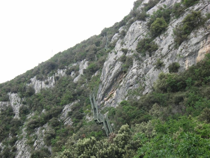
The Busatte-Tempesta forest path
Click for enlargement
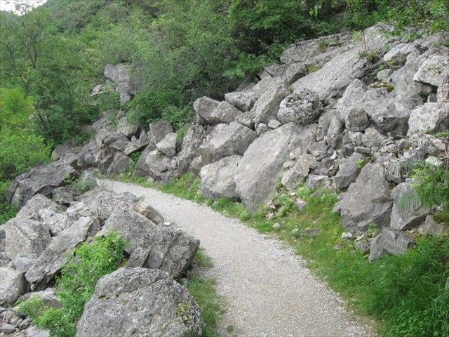
Stage 1: Laste and Marocche (N 45° 51.538 E 10° 52.636)
The area overlooking Nago and Torbole is home to the large stony areas of Marocche and Laste di Nago with their impressive bare rock slabs.
Originating from a series of massive landslides that started at the end of the last glaciation approx. 15.000 years ago, the rock covered the slopes overlooking the two villages.
Thick beds of Jurassic limestone fell downhill, breaking up into a multitude of blocks. The rock block slides was a result of the sleep slope and the presence of thin layers of day intercalated between the limestone beds.
Marocche is the term used to indicate the landslide body that is the large blocks scattered on the mountain slopes.
The term Laste indicates the steep sloped (20-40°) on which slipped the landslide.
Laste and Marocche
Click for enlargement
Stage 2: The Ledro Valley (N 45° 51.431 E 10° 52.468)
The Ledro Valley's V-shaped incision is clearly visible on the western shore of the Lake Garda. The terms U-shaped and V-shaped are descriptive terms of geography to characterize the form of valleys. Most valleys belong to one of these two main types or a mixture of them, (at least) with respect of the cross section of the slopes or hillsides.
For many years the steep, track leading up from the Lake Garda harbour to Biacesa village through the Ponale canyon was the main travel and trading route used by the valley dwellers. During the late 1800s. the scenoc route of Ponale was dug out of the slide of the mountain, which is today used for hiking.
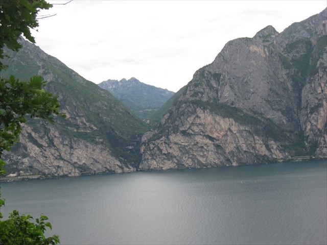
The Ledro Valley
Click for enlargement
Stage 3: A lake of ancient origin (N 45° 50.930 E 10° 51.941)
The Garda (or Benacus) is Italy's largest lake. The landscape was shaped by ancient glaciers, but its origin is much older.
The deep Benacus valley originated from tectonic uplift during the Neogene (25 to 5 million years ago) that created these mountains.
The effects of this remarkable movements, which occurred along large faults crossing the lake basin from south to north, can be seen in the cliff faces overlooking the western shore, where the more ancient rock lies above younger rock.
The east side is less deformed and features sleep and smooth rock surfaces.
While retaining some basic characteristics, the ancient morphology has nonetheless undergone significant changes. More specifically, the current landscape shows clear traces of Wurmian glacial shaping.
Until 15.000 years ago, the Sarca valley and Benaco area were occupied by the great Atesino glacier. As the glacier moved southwards, it smoothed down the slide of the mountains and eroded the bed of the valley.
The Lake Garda as we know it today was formed by the glacier melted. As it filled the valley between these rugged mountains, the water gave the landscape a gentler appearance and mitigated the climate, thus creating a truly unique setting.
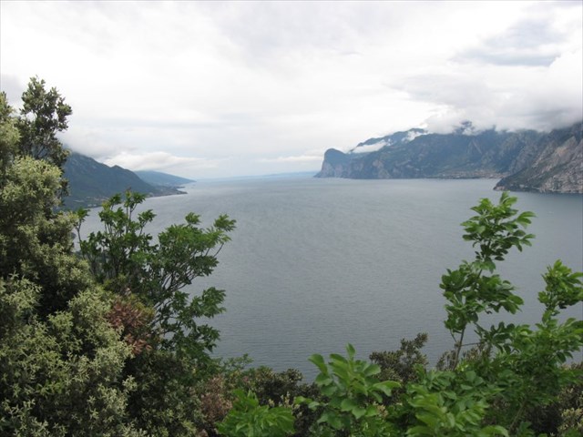
The Lake Garda
Click for enlargement
Stage 4: Miniature landscapes (N 45° 50.625 E 10° 51.968)
Looking closely at the limestone rocks in this area reveals the traces left behind by a process that played a great part in shaping the landscape: the karst phenomena.
Karst topography is a geological formation shaped by the dissolution of a layer or layers of soluble bedrock, usually carbonate rock such as limestone or dolomite, but has also been documented for weathering resistant rocks, such as quartzite given the right conditions.
Due to subterranean drainage, there may be very limited surface water, even in the absence of any rivers and lakes. Many karst regions display distinctive surface features, with cenotes, sinkholes or dolines being the most common. However, distinctive karst surface features may be completely absent where the soluble rock is mantled, such as by glacial debris, or confined by a superimposed non-soluble rock strata. Some karst regions include thousands of caves, although evidence of caves large enough for human exploration is not a required characteristic of karst.
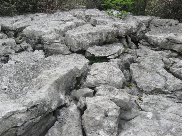
Miniature landscapes
Click for enlargement
End of the Busatte-Tempesta forest path (N 45° 50.367 E 10° 51.837)
Here you got to the end of the path. You have two possibilities now:
1. Walk back to the parking place via N 45° 50.551 E 10° 51.985 and N 45° 50.893 E 10° 52.241.
2. Go to Tempesta and take the bus back to the start.
If you liked the earthcache I would be happy if you give it a favorite point.
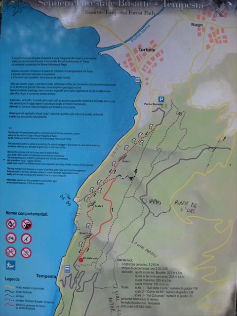
Map of the Busatte-Tempesta forest path
Click for enlargement
To log this earthcache, please answer the following questions (you do not need to wait for a log permission. I will contact and help you in the case one of your answers is wrong.):
- Which "event" is described at stage 1? What happened? Which relics of the event can you see today?
- How many meters is the Ledro Valley above the lake?
- What do you learn about the debris that form the hills of the Garda morainic system at stage 3?
- Which different types of morphologies can be seen at stage 4?
- Please (optional) take a photo of you or your GPS in front of the Lake Garda on the trail.
 |
Versione italiana: |
Il sentiero forestale Busatte-Tempesta è parte integrante del sistema antincendio. Questo avanzato complesso di opere ha l'obiettivo di salvaguardare dal fuoco il grande patrimonio naturale di Quest'area e di limitare il più possibile i danni provocati dagli incendi. provocati dagli incendi.
Il percorso, ad anello, si snoda per lunghi tratti su scale e passerelle metalliche ancorate alla roccia che permettone di raggiungere in sicurezza luoghi altrimenti inaccessibili, offrendo un punto di vista privilegiato sull'ambiente circostante.
Potete parcheggiare la macchina a N 45° 51.936 E 10° 52.901 (Parco delle Busatte) o N 45° 52.127 E 10° 52.737. Da qui andate verso le coordinate (N 45° 51.672 E 10° 52.809) dove parte il sentiero.
Il sentiero forestale Busatte-Tempesta
Clickare per ingrandire
Fase 1: Laste e Marocche (N 45° 51.538 E 10° 52.636)
La Marocche e le Laste di Nago sono le estese pietraie e i nudi tisciono di roccia che dominano il paesaggio a monte di Nago e Torbole.
Sono il risultato delle imponenti frane che, dalla fine dell'ultima glaciazione (circa 15.000 anni fa), hanno interessato a più riprese il versante sopra i due paesi.
Spessi pacchi di calcari del giurassico sono franati a valle frantumandosi in una miriade di blocchi. I distacchi sono stati favoriti dalla forte inclinazione del pendio e dalla presenza di sottili veli argillosi intercalati agli strati calcarei.
Le Marocche sono il corpo di frana, ossia gli enormi accumuli di massi accatastati caoticamente sui fianchi della montagna.
Le Laste sono invece le ripide superfici di strato a franapoggio, inclinate di 20-40°, su cui è scivolato il corpo di frana.
Laste e Marocche
Clickare per ingrandire
Fase 2: La Valle di Ledro (N 45° 51.431 E 10° 52.468)
Sulla sponda occidentale del Lago di Garda è evidente l'incisione a V della Valle di Ledro. Per lungo tempo, il ripido sentiero che dal porto sul Lago di Garda saliva al paesino di Biacesa attraverso la forra del torrente Ponale fu la principale via di comunicazione e commercio per gli abitanti della valle. Solo nella seconda metà del 1800 venne realizzata sul fianco roccioso della montagna l'ardita e panoramica strada del Ponale, oggi trasformata in sentiero escursionistico.
La Valle di Ledro
Clickare per ingrandire
Fase 3: Un lago dall'origine antica (N 45° 50.930 E 10° 51.941)
Il Garda o Benaco: il più grande lago italiano, incastonato in un ambiente ricco di storia e di rara bellezza. Un paesaggio modellato da antichi ghiacciai ma dall'origine assai più remota.
La nascita della profonda valle benacense è infatti da ricercare nelle poderose spinte tettoniche che nel Neogene (tra 25 e 5 milioni di anni fa) hanno fermato queste montagne.
Gli effetti di questi imponento movimento, avvenuti lungo grandi fagile che attraversano da sud a nord la conca del lage, sono particolarmente evidenti nelle pareto strapiombanto della sponda occidentale, dove rocce più antiche sono sovrapposte a rocce più giovani.
Il versante orientale invece è meno deformato ed è dimonato da ripidi liscioni in roccia corrispondenti alle superfici di strato a franapoggio.
L'antica morfologia, pur conservandosi nei suoi caratteri fondamentali, ha subito bel tempo profondi mutamenti. In particolare il paesaggio attuale mostra i segni evidento del modellamento glaciale wurmiano.
Infatti, fino a circa 15.000 anni fa, la valle del Sarca e la conca benacense erano occupate dal grande ghiacciaio Atesino, che muovendosi verso sud ha levigato i fianchi di queste montagne e eroso il fondovalle.
L'attuale lago di Garda si è formato dopo il ritiro del ghiacciaio; l'acqua, insinuandosi nel cuore di questi aspri rilievi ne ha ingentilito il paesaggio e mitigato il clima, rendendo unico questo ambiente.
Lago di Garda
Clickare per ingrandire
Fase 4: Paesaggi in miniatura (N 45° 50.625 E 10° 51.968)
Osservate da vicino le rocce calcaree di questo versante rivelano le tracce di un fenomeno che ha un ruolo rilevante nel modellamento del paesaggio: il Carsismo.
Con il termine carsismo si indica l'attività chimica esercitata dall'acqua, soprattutto su rocce calcaree, sia di dissoluzione sia di precipitazione.
La fase dissolutiva è operata dallo scorrimento superficiale o ipogeo di precipitazioni rese acide dall'anidride carbonica presente nell'atmosfera.
La fase costruttiva si ha quando l'acqua sotterranea, arricchita (fino alla saturazione) di carbonato acido di calcio, sfociando per esempio nell'atmosfera di una grotta, lo rilascia sotto forma di carbonato di calcio insolubile. Tale precipitazione è dovuta all'evaporazione dell'acqua e alla contemporanea liberazione della CO2 spostando la reazione verso il CaCO3. Questo va quindi ad esempio a formare le stalattiti o le stalagmiti a seconda che l'acqua evapori prima di gocciolare sul suolo oppure dopo.
Paesaggi in miniatura
Clickare per ingrandire
Fine del sentiero forestale Busatte-Tempesta (N 45° 50.367 E 10° 51.837)
Adesso hai raggiunto la fine del sentiero forestale, e hai 2 possibilita':
1. Andare a piedi al parcheggio tramite N 45° 50.551 E 10° 51.985 e N 45° 50.893 E 10° 52.241.
2. Vai a Tempesta e prendi l'autobus.
Mappa del sentiero forestale Busatte-Tempesta
Clickare per ingrandire
Per loggare questa earthcache, prego rispondete alle seguenti domande (non dovete aspettare una conferma, io vi contatto se ci sono risposte sbagliate):
- Quale "evento" viene descritto a stage 1? Cosa e' successo? Quali relitti puoi vedere ancora oggi?
- Quanti metri sopra il lago si trova la valle di Ledro?
- Cosa puoi studiare a stage 3 sulla formazione delle colline al sistema morenico del Garda?
- Quali tipi differenti di morfologie puoi vedere a stage 4?
- Prego (optional) fare una foto con te (o il tuo GPS) sul sentiero.
