Twieberge
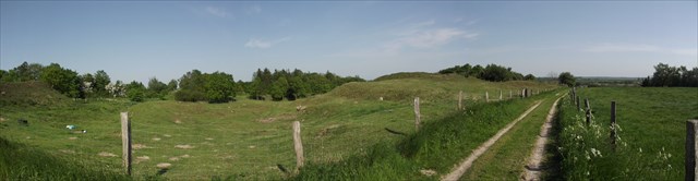
Zwei Berge - so lautet die Übersetzung des Namens Twieberge. Sie sind Teil eines Kliffs zwischen Süderstapel und Siebenberge östlich von Norderstapel. Mit seiner Höhe von 28,8 Metern über NN ermöglicht der westliche Berg bei gutem Wetter einen weiten Blick über die Landschaft.
Bereits gegen Ende der Saaleeiszeit vor 125 000 Jahren hinterließen die Eismassen die langgestreckte Altmoräne, die als Insel aus dem Schmelzwasser herausragte. Die unterhalb liegende Niederung der Eider und Alten Sorge entstand hingegen aus den weiträumigen Urstromtälern der Schmelzwasserflüsse der letzten Vereisung, der Weichseleiszeit, vor ca. 12 000 Jahren. Die steil abfallenden Moränenhänge wurden durch Wettereinflüsse geformt.
Moränen bestehen aus den von Gletschern mitgeführtem und abgelagertem Schutt. Dies ist ein Gemenge aus Erde, Sand, Schotter und Gesteinsblöcken. Viele Findlinge aus den nördlichen Ländern, z. B. Schweden, wurden von den Gletschern auf ihrem Weg bis tief nach Mitteleuropa mitgeführt. Moränen sind daran zu erkennen, dass keine Schichtung und keine Sortierung sichtbar ist.
Altmoränen und Jungmoränen bilden unterschiedliche Landschaftsformen, je nachdem, ob sie in älteren oder in der jüngsten Eiszeit entstanden sind.
In der Neuzeit begann man mit der Bodengewinnung aus beiden Hügeln, die aus Sand, Lehm und Ton bestehen. Um einen weiteren Abbau zu verhindern, wurde der westliche Berg zu einem Naturdenkmal erklärt, der östliche war schon sehr abgetragen.
Der Twieberg ist auch als Lebensraum für seltene Tier- und Pflanzengemeinschaften von Bedeutung. Auf dem sandigen Boden gedeiht Trockenrasen, der sich nur auf einem unbeschatteten und nährstoffarmen Untergrund verbreitet. Sowohl die Pflanzen als auch die Tiere, die in dem Trockenrasen leben, sind in Schleswig-Holstein stark gefährdet. Eine Winterbeweidung mit Schafen und Ziegen sowie begleitende Gehölzrückschnitte erhalten den wertvollen Lebensraum.
Das Schild steht an den Wegpunktkoordinaten, Du solltest es aufmerksam lesen, um die Fragen zu diesem Earthcache beantworten zu können.
Am anderen Wegpunkt befindet sich eine Tür, durch die man auf einen Weg zu den Bergen gelangen kann.
Um diesen Cache zu loggen erfülle bitte folgende Aufgabe:
- Wie hoch ist der Punkt am Infoschild (Meter über NN)? Nimm eine Messung an den Koordinaten vor.
- Um was für ein Kliff handelt es sich genau?
- Wie genau nennt man die Altmoräne, die aus dem Schmelzwasser herausragte?
- Wie nennt man die Abtragung von Hügeln, Gestein und Boden durch Wind und Wasser?
- Beschreibe in eigenen Worten den Unterschied zwischen einer Jung- und Altmoräne! Die Infotafel wird Dir hierzu jedoch keine Antwort geben können!
Schreibe eine E-Mail an den Member-Account und füge deinen Nicknamen, die Meterangabe und die Antworten auf die Fragen ein. Bitte erwähne diese Angaben nicht in Deinem Log.
Mit dieser E-Mail erteilst Du Dir selbst die Logfreigabe, sollte etwas falsch beantwortet sein, melden wir uns.
Über ein Foto, das Dich und/oder Dein GPS vor Ort zeigt, würden wir uns sehr freuen! Das Foto ist freiwillig und keine Logbedingung.
Viel Spaß wünscht der Feenstrumpf
Twieberge
"Two Hills" is the translation of the name Twieberge. They are part of a cliff between Süderstapel and Siebenberge in the east of Norderstapel. With its height of 28,8 Meter above NN the western hill allows you to take a wide look around the landscape.
At the end of the Saale glacial period 125 000 years ago, the ice left the long lower moraine, which looked like an island in the melting water. The bottomland around the hills, which contains now the rivers Eider and Alte Sorge, was formed out of the melting waters after the Weichsel glacial period 12 000 years ago. The steep slopes of the moraine were formed by weather conditions.
Moraines consist of the boulder which the glaciers transported. This is a mixture of sand, boulder, brash and even large stones. The are many errant blocks that came all the way down from the northern countries, i. e. Sweden, that have been transported down to the middle european continent. In moraines you won't find any bedding or layers.
Lower moraines and upper moraines form different landscapes, depending on the glacial period in which they were formed.
Nowadays the terrain was used to get burden out of the hills which consist of sand, clay, and potter's clay. This was stopped by declaring the western hill to a natural monument, the eastern hill was heavily ablated.
The Twieberg is also important as a living environment of rare plants and animals. On the sandy bottom grows a dry grassland which prefers unshadowed and nutrient-poor grounds. The animals and plants living in this dry grassland are very rare in Schleswig-Holstein, too. During the months of winter there are sheep and goats browsing on the area and the cutting of the wood are saving this very special living ground.
There is an information board at the waypoint, you should read it carefully to answer the questions of this Earthcache.
At the other waypoint you'll find a door leading to a path to get to the hills.
Here's what to do to log this Earthcache:
- How high is the info board situated (Meter above NN)? Take a measure at the koordinates.
- What's the accurate name of this cliff here?
- What's the accurate name of the lower moraine rising out of the melting water?
- What's the accurate name of the baring of hills, rocks, and areas by wind and water?
- Describe in own words the difference between lower and upper moraines, the info board won't help you with this question!
Please write an E-Mail to the account's address and put in your nickname, the height in meters and the answers of the questions. Please do not mention all this in your log!
The log may occur with the sending of the answer to us. Should the questions be answered wrong, we will contact you.
It would be very nice to have a photograph showing you and/or your GPS at the coordinates sent within the log! The photo is voluntary and no logging condition.
Happy hunting! Der Feenstrumpf