 (©#1) (©#1)
 «Rocca Clarì - Il Bunker "Centro 51"» «Rocca Clarì - Il Bunker "Centro 51"»
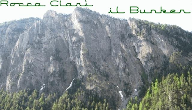
La Rocca Clarì (2051 m), pur non essendo una delle montagne conosciute ed importanti della valle, è sicuramente una di quelle più sovente ammirate, in quanto il suo versante NO precipita in modo imponente e selvaggio nella valletta della Piccola Dora (Gorge di San Gervasio) ed è pertanto ben visibile percorrendo la Strada Statale del Monginevro, tra Cesana T.se e Claviere.
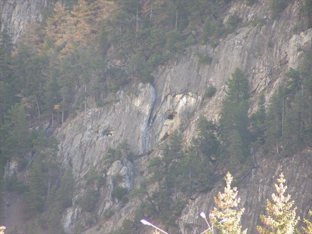
A causa della posizione strategica sul colle del Monginevro, la Rocca Clarì e ricca di strutture belliche abbandonate facenti parte di una vecchia linea difensiva delle seconda guerra mondiale. Una di queste è il centro 51 situato a m 1760 s.l.m. nella suddetta parete NO. Fu costruito nel 1932 e dotato di due mitragliatrici in grado di battere la zona di Claviere ed ospitava un equipaggiamento di 15 soldati.
Accesso: Ci sono due alternative:
1) Diretto, ovvero camminando senza fare la Via Ferrata: Dallo spiazzo (WP Parking) in prossimità del Ponte sulla Piccola Dora seguire il sentiero che si inoltra nella gorge di San Gervasio per una decina di minuti fino al WP "IB", Inizio sentiero Bunker, che sale ripido sulla sinistra, e percorrerlo per una mezz'oretta scarsa.
2) Tramite la Via Ferrata: la stessa è divisa in due parti, collegate tra loro da sentiero. In quel tratto di sentiero, invece di proseguire a sx seguendo l'indicazione per il proseguimento della Via Ferrata, svoltare a destra su sentiero con fondo pietroso evidente ma non segnato e percorrerlo per 5 minuti.
Le coordinate del listing fanno riferimento all'entrata del bunker il quale altrimenti sarebbe difficile da trovare.
Buon divertimento!
 «Rocca Clarì - the bunker "Centro 51"» «Rocca Clarì - the bunker "Centro 51"»
The Rocca Clari (2051 m a.s.l.), although is not one of the well known and important mountains of the valley, is certainly one of those most often admired, as his side Nort-Western rockface falls down steep and impressively into the Piccola Dora's valley (Gorge of San Gervasio) and is therefore clearly visible while travelling on the Monginevro highway between Cesana Torinese and Claviere.
Because of its strategic position on Montgenevre alpine-pass, on Rocca Clarì exist several abandoned war structures which were part of a defensive line in World War II. One of these is the Centro 51, located 1760 m inside the above mentioned steep rockfgace. It was built in 1932 and equipped with two machine guns capable of beating the area of Claviere; equipment 15 soldiers.
Access: There are two alternatives:
1) Directly, walking, without doing the Via Ferrata: From the parkimg lot (WP) in the vicinity of the bridge over the Piccola Dora follow the path that leads into the gorge of San Gervasio for about ten minutes until the WP "IB", Start path to Bunker, which rises steeply to the left and go on for barely half an hour.
2) While doing the Via Ferrata, which is divided into two parts, connected by footpath. In this stretch of path, instead of continuing to the left following the sign for the continuation of the Via Ferrata, turn right on the stony trail (evident but not marked) and go on for about 5 minutes.
The coordinates of the listing refer to the entrance of the bunker which would otherwise be difficult to find.
Have fun!
 «Rocca Clarì - Der Bunker "Centro 51"» «Rocca Clarì - Der Bunker "Centro 51"»
Die Rocca Clari (2051 m ü.d.M.), ist wohl nicht unter den bekannten und "wichtigten" Bergen des Tales, aber sie ist sicherlich einer der am häufigsten bewunderten, da ihre Nord-West Felswand steil und imposant in das Tal der Piccola Dora (Schlucht von San Gervasio) stürzt und daher deutlich sichtbar ist wenn man auf der Bundestrasse von Monginevro zwischen Cesana Torinese und Claviere reist.
Aufgrund der strategischen Lage nahe des Montgenevre-Passes, befinden sich auf der Rocca Clarì einige aufgegebene militaerische Strukturen, welche Teil einer alten Verteidigungslinie aus dem zweiten Weltkrieg sind. Eine davon ist das auf 1760 m in obig erwaehnter Felswand gelegene Centro 51, welches 1932 erbaut wurde, mit zwei Maschinengewehren mit welchen das Gebiet um Claviere beschossen werden konnte ausgestattet wurde und eine Besatzung von 15 Soldaten beherbergte.
Zugang: Es gibt zwei Alternativen:
1) Direkt, ohne die Via Ferrata: Vom Parkplatz (WP) in der Nähe der Brücke über die Piccola Dora, dem Weg, der in die Schlucht von San Gervasio führt, etwa zehn Minuten lang gehen, bis zum WP "IB" (start path to Bunker), der links nach oben führt, und diesen dann eine knappe halbe Stunde hinaufgehen.
2) Ueber die Via Ferrata: Diese besteht aus zwei Teilen, welche durch einen Wanderweg miteinander verbunden sind. Nach dem ersten Teil auf diesem Wegstück, anstatt linkerhand der Fortsetzung der Via Ferrata zu folgen, rechts abbiegen und den steinigen, evidenten aber nicht markierten Weg etwa für 5 Minuten lang hinauf steigen.
Die Koordinaten beziehen sich auf den Eingang des Bunkers, welcher ansonsten nur schwer zu finden wäre.
Viel Spaß!
 
|