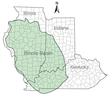
We often look upon the plains and prairies the central part of Illinois and consider it to be relatively featureless, geologically speaking. On the surface, that may be true, but deep in the ground beneath us lies the potential for solving a huge part of the carbon emissions problem. Whether or not you believe global warming is man-made, we can all agree that a reduction in atmospheric pollution caused by carbon dioxide is in everyone’s best interest. That reduction may become a reality as a result of exploiting the natural geological features beneath us.
Most of Illinois lies above the Illinois Basin, a 60,000 square mile oval shaped geological feature. Within this basin are deep coal resources that are uneconomical to mine, numerous mature oil fields, and deep saline formations. Each one of these has the potential to be used to store CO2 and prevent it from reaching the atmosphere. The Illinois Basin is unique in that is has all three of these potential storage features in close proximity to substantial sources of CO2 emissions (the vast majority of these are coal-fired electricity generation facilities). In fact, the Illinois Basin region contributes about 11% of the total CO2 emissions from coal-burning power plants in the US, with emissions exceeding 265 million metric tons. Here in Central Illinois, we are close to the geographic center of the Illinois Basin.

If one drills down through the earth in our region, you will go through a succession of geological features. As you go deeper you pass through Pennsylvanian coal seams, New Albany shale, Maquoketa shale, St. Peter sandstone, and Eau Claire Shale, until you reach the Mt. Simon Sandstone. The Mt Simon Sandstone is coarse grained sandstone that has spaces between the rock that contain very salty brine, about 3 to 5 times more salty than ocean water. Liquid CO2 can be stored in the sandstone as well. It occurs at a depth of 2,000 to 14,000 feet below the surface.
The Eau Claire Shale layer is also very important. It is 300 to 500 feet thick, and is an impermeable rock layer that extends throughout the Illinois Basin. This shale acts as the primary seal, or caprock, to keep any CO2 stored in the sandstone below from escaping.
If you are standing at the coordinates for this EarthCache and look south, you will see the site of one of the first large-scale carbon sequestration projects. The Illinois Basin Decatur Project is a collaboration between the Midwest Geological Sequestration Consortium, Archer Daniels Midland Company (ADM), Schlumberger Carbon Services, and other subcontractors. The project intends to investigate the options for the geological storage of carbon dioxide in the 60,000-square mile geological feature known as the Illinois Basin; to contribute to knowledge of the subsurface and determine if carbon dioxide can be safely stored in the deep rock formations of the Illinois Basin; and to develop measurement, verification and accounting protocols to ensure safe and effective sequestration operations. Over the next three years, it is intended that 1,000,000 metric tons of carbon dioxide will be injected into the Mt. Simon Sandstone at a depth of 7,000 feet. Becoming operational last November, CO2 is being pumped to the injection well at a rate of 1000 tons per day.
The total storage potential of the Mt. Simon Sandstone is estimated to be in the range of 12 to 161 BILLION metric tons of CO2. Thus at current production rates, this formation has the potential to store over 600 years’ worth of carbon dioxide emissions from this region!
So far from being featureless prairie, this area has to potential to contribute a tremendous amount of understanding of how to return carbon dioxide safely to the earth and reduce greenhouse gas emissions.
To log a find for this EarthCache, e-mail me the answers to the following questions:
1. How deep is the Mt. Simon Sandstone formation?
2. What is the importance of the Eau Claire Shale?
3. As you look south/southeast, you can see small black structures, which are called soil flux rings. These are used in the current project as part of the monitoring and verification aspects to ensure that the CO2 is indeed safe and secure below ground. Approximately how many can you see from GZ?
4. Do you believe this a good or bad location for a carbon sequestration test site? Describe what you see at this site that leads you to this conclusion.
The information here was sourced from the websites of the Midwest Geological Sequestration Consortium, the National Energy Technology Laboratory, and Wikipedia articles on carbon capture and sequestration.
Since this cache was published, the National Sequestration Education Center has opened on the campus of Richland Community College, just north of the cache site. Be sure to visit for even more information on this technology and project.