
|

|
|

Un río es un curso natural de agua, que fluye hacia un océano, lago, mar u otro río. En algunos casos, un río simplemente fluye hacia el interior de la tierra o se puede llegar a secar completamente antes de alcanzar otro mar, río, etc.
Un río es parte del ciclo hidrológico. El agua que lleva, generalmente proviene de precipitaciones, acuíferos, manantiales, deshielo anual y de grandes superficies heladas como los glaciares. Potamología es el estudio científico de los ríos.
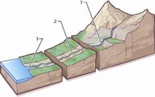
Partes de un río
Cada río tiene tres partes:
Curso Alto: es su primera parte, se encuentra normalmente en las montañas. El agua desciende con fuerza por su superficie, con lo que el efecto erosivo es muy alto.
Curso Medio: el grado de inclinación es menor. El agua desciende mas lentamente, llevando materiales de erosión. El río puede formar meandros adaptándose de esta forma a los obstáculos.
Curso Bajo: es donde el río termina su viaje, normalmente en el mar, donde sedimenta los materiales que ha ido dragando.
La desembocadura del río puede ser de dos tipos:
Delta: tierra formada por los materiales acumulados por el río, cuando entra en contacto con el mar.
Estuario: lugar donde el río entra en contacto con el mar; donde el agua de mar entra en la boca del río. En esta zona se dan fuertes mareas.
El RIO LLOBREGAT
Su nacimiento se encuentra en la población de Castellar de N'hug (Barcelona) a 1.259 m de altitud en la Sierra del Cadí y su desembocadura en el mar Mediterráneo, en el término municipal de El Prat de Llobregat. La totalidad de su cuenca se encuentra en Cataluña. Atraviesa la Cordillera Litoral, alternándose el aprovechamiento industrial, en los desfiladeros con el agrícola en las llanuras. Desemboca formando un delta pantanoso. En esa zona se encuentran numerosas localidades que en su tiempo fueron esencialmente agrícolas y que incluyen Llobregat en su nombre, como San Baudilio de Llobregat, Cornellá de Llobregat o el mismo El Prat de Llobregat. El río supera los 170 km de longitud y tiene una cuenca de 4.948 km².
En la cuenca del Llobregat se situaron numerosas industrias en los siglos XIX y XX que aprovecharon su energía y agua, destacando las llamadas «colonias industriales». El agua del río recibe numerosos aportes de contaminación por industrias y por residuos líquidos de los núcleos urbanos situados a lo largo de su curso, aunque se hacen esfuerzos por disminuirlos. Además, el Llobregat sufre hoy una fuente peculiar de contaminación por los residuos de las minas de potasa, que hacen que su salinidad sea elevada.
La cuenca del Llobregat es la fuente del agua de bebida para poblaciones como Sabadell, Hospitalet o buena parte de la misma Barcelona. La contaminación de su agua plantea problemas por la formación de trihalometanos (THMs), compuestos orgánicos de cloro y bromo que se forman al desinfectar el agua con cloro para eliminar virus y bacterias, y que pueden causar cáncer. La contaminación del río con sales de potasa condiciona un predominio de THMs bromados en el agua de bebida procedente del Llobregat, fenómeno infrecuente
En la desembocadura, el nivel de su cauce se encuentra sobre la llanura litoral, por lo que ha ocasionado graves inundaciones (como en 2005) que alcanzan, inclusive, a la zona del aeropuerto de El Prat. Ello se debe a que la gran cantidad de sedimentos que ha arrastrado a través del tiempo ha elevado el nivel del cauce y también el de los propios diques naturales que lo limitan. Estos diques presentan brechas que no resisten las crecidas más fuertes, especialmente, hacia el sur. En el año 2004, el cauce del río Llobregat fue desviado 2 kilómetros hacia el sur en su tramo final, desde el puente de Mercabarna, para permitir la ampliación del puerto de Barcelona.
Para poder registrar este Earthcache deberéis responder a una serie de preguntas y enviarme un correo con las respuestas.
1.- A que altura nace el rio?
2.- Que mineral provoca el alto nivel de salinidad del rio?
3.-En las coordenadas de origen encontrareis una fuente. Existen bancos de piedra a ambos lados, quantos hay?
4.- Para dar fe de haber estado en la zona, debeis fotografiaros con vuestro GPS y el rio a vuestra espalda, Enviad las respuestas y logead el cache (si estuvieran mal se os comunicaria)
|
EL RIO LLOBREGAT |

Eng.
A river is a natural water course that flows into an ocean, lake, sea or another river. In some cases, a river simply flows into the ground or it can get dry completely before reaching another sea, river, etc..
A river is part of the hydrological cycle. The water, usually comes from rainfall, aquifers, springs, annual thawing and freezing large areas as glaciers. Potamology is the scientific study of rivers.
Parts of a River
Each river has three parts:
Course High: it is the first part, it’s usually found in the mountains. The water comes down bravely by its surface, so that the erosive effect is very high.
Middle Section: the pitch is lower. The water descends more slowly, bringing materials to erosion. The river can meander thereby adapting to obstacles.
Under Course: it’s where the river ends its journey, usually into the sea, where sediments materials has been dredged.
The mouth of the river can be of two types:
Delta: land formed by the material accumulated by the river, when in contact with the sea.
Estuary: where the river comes into contact with the sea, where sea water enters the mouth of the river. In this area there are strong tides.
THE RIVER LLOBREGAT
Its birth is located in the town of Castellar de N'Hug (Barcelona) to 1,259 m altitude in the Sierra del Cadi and it flows into the Mediterranean Sea, in the municipality of El Prat de Llobregat. The whole of the basin lies in Catalonia. It crosses the coastal mountain range, alternating industrial use in the canyons with the agricultural plains. Ends forming a marshy delta. In this area there are many places which once were mainly agricultural and Llobregat including your name, as St. Baudilio de Llobregat Cornella de Llobregat or the same El Prat de Llobregat. The river is over 170 km in length and has a watershed of 4,948 km ².
In the Llobregat basin were placed numerous industries in the nineteenth and twentieth centuries who used their energy and water, highlighting the so-called 'industrial colonies.' The river receives numerous contributions by industry and pollution runoff from urban centers located along its course, although efforts are made to minimize them. In addition, the Llobregat today suffers a special source of pollution by waste from potash mines, which make its salinity is high.
The Llobregat basin is the source of drinking water for towns like Sabadell, Hospitalet or most of Barcelona itself. Contamination of the water poses problems for the formation of trihalomethanes (THMs), organic compounds of chlorine and bromine are formed when disinfecting water with chlorine to eliminate viruses and bacteria that can cause cancer. River pollution with salts of potash conditions a predominance of brominated THMs in drinking water from the Llobregat, rare phenomenon.
In the mouth, the level of its bed is on the coastal plain, so it has caused severe flooding (and 2005) reaching, even to the airport area of El Prat. This is because the large amount of sediment that has washed over time has raised the level of the channel and those of their natural levees that limit. These dams have gaps that can not withstand floods stronger, especially towards the south. In 2004, the river Llobregat was diverted 2 miles south on its final stretch, from the bridge of Mercabarna to allow expansion of the port of Barcelona.
THE EARTH
To register you will have to answer this EarthCache a series of questions and show that you have been in the area (I recommend you take a picture showing where the GPS will go out the fastest way and effective).
To register you will have to answer this EarthCache a series of questions and send me an email with the answers.
1. - How high the river is born?
2. - What mineral causes the high level of salinity of the river?
3.-In the coordinates will find a source of origin. There are stone benches on either side, quanta there?
4. - In addition you can make a picture with your GPS with you and the river at your back