*** This cache is part of the Taking Flight GeoTour. Anyone can claim this cache, but to be eligible to receive a Taking Flight GeoTour prize tag, geocachers must complete the activities in this survey for at least 12 caches on the tour.***
Welcome to Ungarelli Preserve. When Manatee County acquired this land, there was a great deal of trash and exotic invasive plants. The Natural Resources Department has worked hard to restore the site back to a more natural environment. Since this restoration, a wide variety of birds have been spotted including red bellied woodpeckers, red-shouldered hawks, brown pelicans, killdeers, turkey vultures, white ibises, ospreys, grackles, roseate spoonbills, American crows, tri-colored and great blue herons.
Stretch out your arms wide and look from fingertip to fingertip. This is your arm span. In birds, this is called the wingspan – the total length of the bird’s wings, measured between the tips of the primary feathers on each wing when the wings are fully extended. Each bird’s wing shape is unique to its particular type of flight; the wingspan will help determine the birds’ most common type of flight. Birds that have fast flight and dive, like falcons, have short wings that taper to points and are built to allow for rapid wing beats and high speed. Some birds have elliptical wings that are short and rounded allowing for tight maneuvering in confined spaces like tree-filled forests. The accipiter hawks, a predator who hunts birds in the trees, are known for this type of wing. Birds that soar for long periods of time, such as albatrosses and other seabirds, have longer wings built for “dynamic soaring”. Their wings can utilize different wind speeds at different heights above the ocean to provide lift. Other birds have wings that allow for hovering, such as kingfishers and hummingbirds. By studying the wingspan and overall wing shape of the bird we can learn a great deal about the flight mechanics of each individual species.
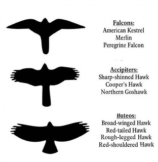
Flight silhouettesWhy is a bird’s wingspan important? The shape of the wings, and the size, together with the body create a characteristic flight silhouette that we can use to help identify different types of birds.

Visit the sites along the Taking Flight GeoTour (TFGT) and learn about Manatee County's wild spaces and the amazing feathered friends that live in them. Along the way, you will be challenged to become a citizen scientist, a preserve ranger, a detective, a historian, an excellent geocacher. Caches are located in birding hot spots throughout Manatee County's publicly accessible conservation Preserves. Each one highlights a specific bird species or aspect of bird life providing you with opportunities to learn more about these creatures and what we can do to help them survive. Caches also focus on protecting the region's waterways, bays, natural watersheds, and habitat areas for many of our area's feathered friends.
The Taking Flight GeoTour launched August 20, 2012 and includes 18 caches within Manatee County.
To be eligible to receive a Taking Flight GeoTour prize tag, geocachers must complete the activities in this survey for at least 12 finds on the tour. Keep this survey open in your browser, only click submit when at least 12 finds have been completed. Survey responses will be automatically sent to Manatee County staff. Prize tags can be redeemed on Saturday mornings from 9am - 12pm at The NEST at Robinson Preserve located at 840 99th St NW, Bradenton, FL 34209. If you are unable to collect your prize tag in person, please contact ecoevents@mymanatee.org to arrange for your tag to be sent in the mail. Tags will be available while supplies last.
Thank you for assisting with the Taking Flight GeoTour: