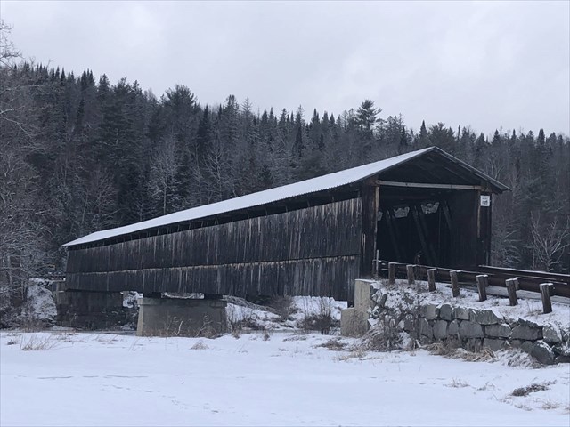
Mount Orne Covered Bridge in Winter
Photo taken on 19 February 2022.
Bridge History:
There has been a bridge spanning the Connecticut River at this location to connect the towns of Lancaster, NH to Lunenburg, VT since the 1860s or 1870s. The original bridge was built by the Union Bridge Company, which operated it as a toll bridge until it was destroyed by a log jam in 1905. Ferry service then connected the towns for a few years.
In 1911, the current bridge was built by the Berlin Construction Company. Each town contributed $2,500 towards the construction price of $6,678. The remaining $1,678 was raised by subscription. The timber for the bridge was precut and assembled at the site. The bridge consists of two spans of wood-and-iron Howe trusses, resting on stone abutments and piers which have been partially faced in concrete. The overall length of the bridge is 267 feet, with the western span measuring 134 feet and the eastern span one foot less. The bridge has an overall width of 20.5 feet, with a roadway of 15.5 feet. The bridge is covered by a corrugated metal gable roof and is sided in vertical boarding that extends only partway to the eaves. The siding extends around to the insides of the portals.
The low water line on the Vermont side of the river marks the boundary between the states. Most of the bridge, therefore, stands in New Hampshire; the state boundary sign is mounted 32 feet inside the west portal.
In 1969, a truck loaded with highway salt dropped through the deck and landed on the ice below. The front of the truck hooked on a steel rod in the bridge while the rear rested on the ice. The truck was raised, disengaged from the bridge, and lowered to the ice. It was quickly dragged away from the salt weakened area, turned upright and loaded onto a flatbed on the Vermont side of the river.
The bridge was closed on July 5, 1983 for twelve weeks to allow rehabilitation by the state of New Hampshire at a cost of $133,000. Funding came from the towns of Lancaster and Lunenburg, the states of New Hampshire and Vermont, and a federal Historic Preservation Fund matching grant from the National Park Service of the U.S. Department of the Interior through the New Hampshire Division of Historical Resources. The rededication of the bridge took place on November 23, 1983. The Mount Orne Bridge is listed on the National Register of Historic Places.
The Mount Orne Covered Bridge and another covered bridge across the Connecticut River about 37 miles to the north at Columbia, NH, are the only remaining New Hampshire highway bridges which are supported by Howe trusses. (One other highway bridge of the same type remains in Stowe, VT.) The Mount Orne and Columbia bridges, which were completed in successive years (1911 and 1912, respectively), are also the last covered bridges built on public highways during the historic period of covered bridge construction in New Hampshire and Vermont, which began about 1820.
Cache History:
The solid rock-seekers initially placed this cache as a replacement for the prior cache on the Vermont side of the bridge, Anthony's Adventure, by re-purposing a matchstick container which 76-CJ7 had placed at the site of that cache. The current cache, however, is on the New Hampshire side and has been subsequently replaced by a camo-taped baby soda bottle (preform).