
 The coordinates are on Mount Whitney. It is at high elevation and requires a wilderness permit to enter, even for day hikes. Be sure to be prepared if you attempt this EarthCache.
The geomorphology of a mountain range is difficult or impossible to see from within in it. The best way to see it would be from the air. The next best is from its highest peaks where the landforms of the mountain range can be seen in all directions. This EarthCache takes you to the highest peak of the Sierra Nevada Mountain Range and the continental United States to examine the geomorphology of the Sierra Nevada Mountains.
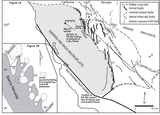 The Sierra Nevada Mountain Range sits on the eastern side of the Sierra Nevada-Great Valley Block. This block is a large piece of the crust that extends from the eastern edge of California’s Coast Ranges to the eastern side of the Sierra Nevada Mountains and from the Garlock Fault on the south to about the northern end of the Sacramento Valley. Some consider this block a micro-plate.
The current Sierra Nevada Mountains began to form about 10 million years ago. At this time it is thought that the mantle heat from the formation of the Basin and Range Province to the west contributed to the buoyancy of the western portion of the block causing the granitic rocks to float higher in the mantle forming the Sierra Nevada Mountains. At the same time, sediments that accumulated on the eastern portion of the block weighed down the eastern portion creating the Great Central Valley. As a result the Sierra Nevada-Great Valley Block effectively tilted a little like a seesaw.
While the granitic rocks of the Eastern Sierra were uplifted along the Sierra Nevada Fault, the Owens Valley Basin formed directly east as stretching in the crust that formed the Basin and Range Province pulled the White Mountains away from the Sierra Nevadas. The rocks between the two ranges dropped down along normal faults forming a graben. The basin that is about two miles below the highest peaks of the Sierra Nevada. However, sediments have filled about half of this basin.
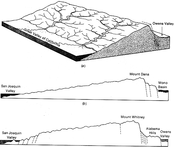 In the area east of Mount Whitney and the town of Lone Pine, a series of normal faults are present forming a sort of stair step drop. The first drop is from the top of Mount Whitney down to the Alabama Hills and the second is from the Alabama Hills to the bottom of the basin that is now filled with sediment.
Since the Sierra Nevada-Great Valley itself remained relatively cohesive during its tilt, a mountain range that is very asymmetrical formed. The western side of the Sierra Nevadas are on the top of the Sierra Nevada-Great Valley Block and form a long and relatively gentle slope. However, the eastern slopes of the mountain range mark the edge of the block that tilted up, so its slopes are steep tall and steep.
Logging questions:
- The text "GC3RQEW Sierra Nevada Mountain Range Geomorphology" on the first line.
- The number of people in your group (put in the log as well).
- From the coordinates are you able to see the two steps down to the bottom of the graben?
- Can you see the asymmetrical nature of the mountain range from this spot? Which side appears to have a steeper drop?
The following sources were used to generate this cache.
- Moore, James G. 1987, Mount Whitney Quadrangle,Inyo and Tulare Counties, California Analytic Data. U.S. GEOLOGICAL SURVEY BULLETIN 1760.
- Moore, James G. 2000. Exploring the Highest Sierra. Stanford University Press.
- R.A. Schweickert, M.M. Lahrena, K.D. Smithb, J.F. Howlea, G. Ichinosec. 2004 Transtensional deformation in the Lake Tahoe region, California and Nevada, USA.
- Moore, J.G., 1981, Geologic map of the Mount Whitney quadrangle, Inyo and Tulare Counties, California: U.S. Geological Survey, Geologic Quadrangle Map GQ-1545, scale 1:62500.