Access is straightforward and wheelchair friendly - one of the tasks below may be a little tricky unless accompanied. There is plenty of parking space nearby (charges apply 1000-1800 daily 70p/hour £4max 5 hrs+) and the given parking coordinates at Pebble Beach CP are adjacent to a large grassy area which is ideal for exercising dogs. Note that there are local restrictions on cycling (and dog access to some of the beaches during the summer). Plenty of facilities for the little ones too and there are other objects of interest as well as the geology – the concrete areas used to construct the WW2 Mulberry Harbours, gun batteries, a trig point and SSSI lagoons at Gilkicker point, Mini Golf, swimming and the inshore lifeboat station.
Much of this information has been sourced from SCOPAC – more detailed and academic information is available here SCOPAC Hamble to Portsmouth Harbour.
The area is developed in Tertiary (Eocene) rocks and overlying Quaternary fluvial and niveo-fluvial sediments, which provide sands, silts, clays and gravels of low resistance to the modest erosional energy of waves in the eastern Solent. Either drift materials or protection structures largely conceal Sandy Eocene strata, but they do outcrop across the foreshore and at the base of the cliffs west of Hill Head. Gravel beaches are continuous along the entire frontage, with groyne and promenade protection between western Browndown and Hill Head; most of the rest of the beach environment is undefended except for sea walls between Gilkicker Point and Portsmouth Harbour entrance .
Natural cliffs, up to 12 m in height, developed in Plateau Gravel and Bracklesham Sands, are developed between western Lee-on-the-Solent and Solent Breezes; however, the former cliff line in the central and eastern parts of Lee-on-the-Solent has been artificially regraded and protected. The seawall east of Gilkicker one of the most long-established protection structures in the SCOPAC region, and conceals the foundations of the Haslar spit that projects into, and helps define, the mouth of Portsmouth Harbour.
The shoreline between Portsmouth Harbour entrance and the mouth of the River Hamble is bounded at the eastern and western extremities by channels swept by rapid tidal currents, which form effective barriers to lateral sediment transport. It is therefore identified as a discrete littoral drift compartment or cell.
Littoral (or longshore) drift is the process by which sediments are transported along the coast by a combination of wind/wave direction and backwash as the waves retreat and deposit the sediment.
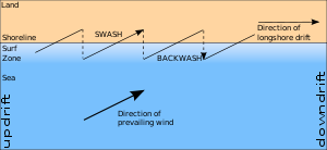
This diagram illustrates the process, more detail can be found in enotes here.
On this stretch of coastline two unequal subsidiary sub-cells are recognised on the basis of a littoral drift divide in the vicinity of Solent Breezes. The larger unit or pathway can be differentiated into an erosional shoreline from Solent Breezes to Lee-on-the-Solent and an accreting gravel shoreline from Browndown to Gilkicker Point. Overall, the system exhibits classic source-pathway-sink characteristics with low eroding cliffs contributing small quantities of sand and gravel to the shoreline. This sediment is generally moved southeastwards towards accreting sinks at Browndown, Stokes Bay and Gilkicker.
Potential sediment input pathways include fluvial input (limited by stable discharge of rivers and small catchments of low erodibility); onshore feed (which appears to occur around Hill Head, but is unquantified) and coast erosion which is the most obvious sediment input.
Low cliffs of Tertiary sands and sandy clays capped by Plateau Gravels have eroded with approximately 80% of this sediment comprised of sand and gravel capable of remaining on the foreshore, the remainder is suspended fines liable to offshore loss. Two distinct and divergent littoral drift are recognised, with the divide located close to Solent Breezes. The westward drift extends to Hook Spit whilst eastward drift transports beach materials past Hill Head, Lee-on-the-Solent, Browndown and Gilkicker Point towards the Portsmouth Harbour tidal channel. Construction of groynes along much of the coast between Hill Head and Browndown has almost certainly reduced the actual drift rate to below the estimated potential. Some recent increases may have occurred due to greatly enhanced sediment availability following large-scale renourishment at Lee-on-the-Solent in 1996. Some of this material is now spilling downdrift to nourish the Browndown frontage.
Intertidal foreshores between Solent Breezes and Lee-on-the-Solent are likely to continue to narrow, especially in front of defences. Presently active cliffs are likely to erode slightly more rapidly in future due to sea-level rise and climate change and contribute additional sediments that would drift towards the south-east. Groyne fields at Hill Head would probably intercept the majority of these materials leading to some beach accretion. Further downdrift at Lee-on-the-Solent, drift inputs would be negligible, but losses would continue to occur to Browndown so that the newly replenished beach would tend to narrow, albeit at slow rates due to its large volume and controlling groynes.
The future stability of the low-lying Browndown, Stokes Bay and Gilkicker Point frontages would depend upon the extent to which shore drift from the north-west can be maintained to supply sediments. In the short-term, these areas could benefit from inputs (losses) from the Lee-on-the-Solent replenished beach. In the event of cessation of drift inputs from the north-west, natural re-working of the extensive stored sediments of the Browndown foreland would be likely.
To log this cache you will need to visit at a time when the whole beach profile is evident (or if arriving early wait for LW!) tide times here
1. At the given coordinates look at the board to see interesting background information on the area.
2. At this point of the beach describe the profile and content of the beach between LW and the HW line and above the HW mark.
3. Given the information on the cache page how do you account for this?
Email your answers to GC3V6BD@gmail.com and please post an optional photo of you and/or GPS with the forelands or beach as a backdrop
FTF honours to Sprogkeepers