A Mile Wide and an Inch Deep EarthCache
A Mile Wide and an Inch Deep
Please note Use of geocaching.com services is subject to the terms and conditions
in our disclaimer.
The Platte River is the most magnificent and most useless of streams. Abstraction made of its defects, nothing can be more pleasing than the perspective which it presents to the eye. Its islands have the appearance of a labyrinth of groves floating on the waters. Their extraordinary position gives an air of youth and loveliness to the whole scene. --Washington Irving 1832
The Platte River
The Platte River begins at the confluence of the North Platte River and South Platte River at North Platte, Nebraska (2762’ elevation). From there it flows approximately 310 miles to its mouth at Plattsmouth, Nebraska (942’) where it discharges into the Missouri River. Rocky Mountain snowmelt supplies the headwaters of the North Platte River and South Platte River which can be found in Colorado. The Platte drainage basin encompasses nearly 85,000 square miles!
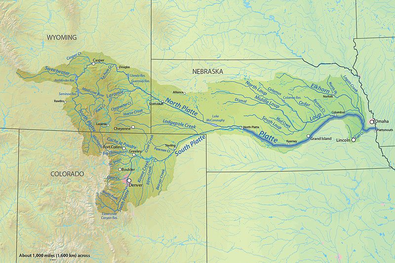
Named “flat water” by the Omaha and Otoe Indians as Nibthaska or Nibrathka respectively, French trappers later named the river “Plat” the French word for flat. Years later, pioneers traveling the many westerly trails on the Great Platte River Road described the Platte River as “a mile wide and an inch deep.”
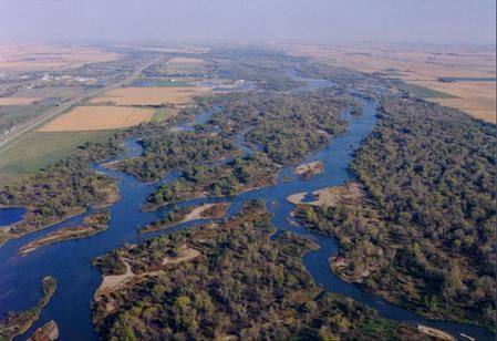
The Platte River is a rare river system known as a braided river. A braided river is defined as “a stream consisting of multiple small, shallow channels that divide and recombine numerous times forming a pattern resembling the strands of a braid.” A braided river will typically form when high sediment loads and/or steep channel gradients exist.
The majority of the Platte River is broad and shallow, following multiple small channels and separated by sandbars which are typically small and often only temporary. The sandbars or islands are often eroded and deposited a short distance downstream over varying periods of time. Islands are composed of sediments varying in size from fine sand and silt to large gravel. Often, vegetation will grow and cover the island if river flows remain low for extended periods of time or the island is able to stabilize itself to slow or nearly stop erosion.
The unique habitat created from the Platte River is home to a wide variety of animals and plays host to an even larger number for migratory birds each fall and spring. The spring migration of the Sandhill Cranes can be quite an exciting time on the Platte River. Half a million Sandhill Cranes roost on the open sandbars to protect themselves from predators. Occasionally an endangered Whooping Crane might be spotted amongst the flocks – although it’s a rare sighting. Millions of ducks and geese also use the river and rainwater basin to refuel before continuing their long migrations. Other endangered species that might be seen on the river are Piping Plover and the Interior Least Tern, which nest on the sandbars of the Platte. Additional animals you might encounter include bald eagles, herons, frogs, snakes, salamanders, raccoons, turkey, deer, and antelope just to name a few. Believe it or not, elk, moose, and even mountain lions have been spotted along the river in recent years.
Cache Information
You will be observing the south channel of the Platte River. To view the north channel you'd have to travel a mile north on the trail on what is called Kilgore Island!
The posted coordinates will bring you to two signs along the bridge to get a few answers, the rest you will have to do the work! The easiest trailhead for access is from Fort Kearny State Recreation Area. A state park permit is required to use the trailhead. The cinder trail is an old railroad grade that is well maintained. Hikers and bikers can be seen all along the trail - we even push our kids in strollers. The north trailhead near the interstate has been closed for several years after a fire completely burned the historical bridge that crossed the north channel of the river.
Logging Requirements
Please email your answers to us at xctracker@gmail.com.
Use the signs to get the first two answers:
What has invaded the broad valley of the Platte to reduce the channel width 70-90%?
The title of one of the signs relates to the title of this EarthCache - what is the difference?
What is the width of the river here? For the sake of simplicity, you can measure the length of the bridge.
Use the stairs to get down to the large island below the bridge.
How long do you estimate this island has been here? What evidence do you observe to get your answer.
What types of sediments do you observe on the island?
What is the elevation on the island?
In general, what is the slope of the river from North Platte to this location? What is the slope of the river from this location to Plattsmouth? The confluence of the river is nearly 100 river miles upstream of the posted coordinates.
Did you see any wildlife? Please report it with your log!
Also, this is a dynamic area - pictures of the river, animals, and your geocache adventure on the trail are encouraged! It will be interesting to see the changes from season to season and year to year!
References
Nebraska Game and Parks Commission
National Wildlife Federation
Fitzpatrick, Lilian. Nebraska Place-Names. Lincoln: University of Nebraska Press, 1925.
Encyclopedia Britannica.com
Dictionary.com
Wikipedia - Platte River
Wikipedia - Braided River
Permission for placement of this EarthCache was granted by Gene Hunt, Fort Kearny Park Superintendent.
Additional Hints
(No hints available.)
Treasures
You'll collect a digital Treasure from one of these collections when you find and log this geocache:

Loading Treasures