A state park vehicle sticker is required to do this EarthCache.
Stickers can be purchased upon arrival at the property.
Please remain on trails at all times.
During winter, the Brachiopod trail
is also used by snowshoers.
The Trail:
Pick up a Brachiopod Trail guide at the visitor center before starting your hike. It will help introduce you to some of the geologic treasures this special area has to offer and possibly help answer the questions at the end. The 1.5 mile interpretive trail will take you to 16 marked sites, listed in the guide. This EarthCache will have stops at 6 of those sites. Walk out onto the rock shelf shore or rest on the Leopold bench and listen for the ovenbird or American redstart. Look for white-tailed deer in the forest area or barred owl high in the trees. The steep forested dunes found here are the highest dunes on the western shore of Lake Michigan. This flat trail was designed to be accessible for all people, but it might be difficult for people with certain mobility aids.
Limestone:
Four hundred million years ago a shallow saltwater sea covered much of Wisconsin. Corals, brachiopods, crinoids and other early marine life lived and died here. As time passed, their skeletal remains (calcium carbonate) built up, layer upon layer. With time, temperature and pressure working upon these layers, they eventually transformed into limestone. Over time the replacement of calcium within the limestone with magnesium, created a harder rock called dolostone. With climate stabilization and global warming, the waters receded, exposing these rock layers that you see at this site.
Wisconsin Glaciation:
The Wisconsin Glaciation Episode was divided into three separate ice ages. They were called the Tahoe, the Tenaya and the Tioga. The last and least severe of the 3, the Tioga, came to an end around 10,000 years ago. These Glacial Episodes eroded the landscape as they slowly pushed their way southward.
Karst Topography:
Rain, passing through the atmosphere picks up CO2. CO2 dissolves in water forming a weak carbonic acid solution. Once becoming groundwater, it then flows through fissures and bedding planes within the limestone bedrock. Limestone, having a high calcium carbonate content, dissolves easily in these acids. A process technically called dissolution. The area attacked by dissolution is called Karst. Karst topography can include impressive caves, labyrinths, passages, aquifers and sinkholes (dolines).
Glacial Erratics:
A Glacial Erratic is a rock usually referred to simply as a field stone, a boulder, intercoursite or a leaverite (as in "leave-er-right" there) by the layman. These leave-er-rights are caused primarily by the processes of abrasion and plucking. Both of these processes lift and separate various sized rocks, entrap them and carry them along with the advancing glacial ice. When the glacial ice melts and retreats, the rocks entrapped within are stranded in a landscape foreign to their parent bedrock. Geologists define these orphaned rocks as a Glacial Erratics.
Beach Ridges:
Beach ridges were once the shorelines of ancient, and now non-existent, lakes. They were formed during a time when lake water levels were much higher due to the meltoff of glacial ice. As water levels fell (or uplift occured) these ridges would remain high and dry, leaving a record of past lake levels and shorelines. Beach Ridges are fairly common around the Great Lakes area.
Dunes:
A sand dune needs the following three things to form. A large amount of loose sand in an area with little vegetation, usually on the coast of a lake or sea. A wind or breeze to move the sand grains and an obstacle causing the sand to lose momentum and settle. Once a dune has formed, plant life takes a foothold and begins to cover the dune. In time plantlife can become so thick that the dune will be entirely covered in plants, bushes,shrubs and even trees. They may appear as a forested hill and not look anything like a dune at all.
Email your answers to the questions, to me, using the link in my profile only. If your answers are not recieved by me in an appropriate amount of time, your log will be deleted. Photos are accepted and appreciated as long as the answers to the questions are not revealed. You do not have to wait for confirmation from me before logging this cache as completed. Most of all……learn……and enjoy the view.
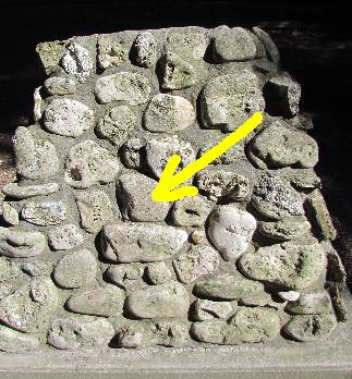
WP1. These coordinates bring you to the starting point of the Brachiopod Trail. The picture above has an arrow pointing to a specific animal fossil on the backside of the cairn. What type of ancient animal did this shell belong to? (Hint: It is not a brachiopod).
WP2. These coordinates bring you to a glacialy scraped and eroded landscape not far from the beach. This landscape is basically one step up from being an Alvar. Looking at the fallen tree rootballs, and the holes created by them, what do you believe makes up the composition of the soil? (sand, rock, dirt?)
WP3. At these coordinates you will see an example of Karst topography. What is the size of this fissure/cavern/doline. Is there any airflow in or out of this formation that you can feel/see? What is the technical term for the loss of rock that creates this Karst topography?
WP4. What is the average size of the erratics found at these coordinates?
WP5. At these coordinates you are standing at the top of an ancient beach ridge. In what direction does the abandoned ridge run? What is the height difference from the top of the ridge to the bottom of the trough? You can see the bottom of the trough from the ridge crest.
WP6. What type of geologic formation is at these coordinates? What makes this formation different from others that you have seen?
EarthCache placement form has been submitted to
Carolyn Rock
Natural Resource Educator
Whitefish Dunes State Park