Clevedon is very much a town of 'rural style'. Farming is still a way of life but increasingly, Clevedon offers the rural lifestyle, close to the sophistication and amenities of Auckland city. The land is a lush paradise of rolling countryside. The Hunua Ranges to the south provide a stunning backdrop, while to the east lies Kawakawa Bay and Orere Point. Clevedon Village itself offers kiwi hospitality, country charm and an array of little shops, galleries and cafés.
The Wairoa River meanders gently through Clevedon and once played an important role in its development. In the late 1800s, European settlers began clearing the thick native bush on the river bank and supplies and passengers were ferried to and from Auckland and out to the Hauraki Gulf.
The earliest European settlers were the McNicol and Hoye families who bought land on the East and West sides of the Wairoa River in 1853. The arrival of the immigrant ship SS Viola, which departed from Glasgow, arrived in Clevedon on the 4th April 1865. This shipload of passengers made for a large influx of farmers, miners, carpenters etc to the area and the farmers took over 10 acre blocks of land that had been allotted to them by the Government. Many others were moved to Papakura and eventually spread out over a wider area.
The New Zealand land wars left their mark on Clevedon around 1863. A redoubt was built by the Militia beside the Anglican Church and a stockade constructed by what is now the McNicol Homestead and Museum. There were minor battles and some deaths from both sides. The disruption to settlers however was quite major; wives and children moved to safe havens in Auckland and the stockade providing sanctuary at night for those left behind.
But for the Wairoa River, Clevedon would not exist as it is today! The only practical access to the district was by way of the river. The tidal (and navigable) extent stops at the bridge and the journey down river to the Firth of Thames takes about one hour. All manner of little ships used to navigate up and down the river carrying farming equipment, produce, (predominately butter, manufactured in Clevedon) and people who needed to visit coastal communities or do their shopping in Auckland. As a rule of thumb it was a twelve hour day to Auckland and return; four hours travelling in each direction plus four hours shopping in Queen Street.
The most famous of these ships (and last) was undoubtedly the SS Hirere, built at Devonport for the newly established Clevedon Steam Navigation Company in 1896 to ply its trade in the Hauraki Gulf using the “Port of Clevedon” as its base. This regular service continued until 1928 when the road system was improved to the extent that boat traffic was deemed to be uneconomical. Except for the use of safe berthage for private motor vessels the river returned to its quiet meanderings until renewed interest in the last few years by recreational groups.
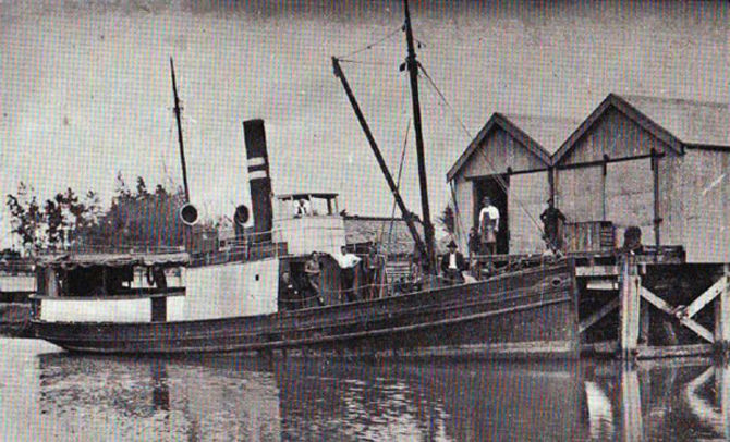 The SS Hirere
The then and now provide for a remarkable contrast: working horses for tractors, a quiet Sunday and Church for recreation and farmers markets, a coal range to microwave, dairy farmers to life-stylers, billy tea to high tech coffee machines....
While you are in the area, be sure to check out the Society’s Museum at the McNicol Homestead - Just across the river from the Clevedon bridge. Opening hours are 1 – 4pm weekends.
WAYPOINT 1
S36 59.ABC E175 02.DEF
A = Third digit in starting year of Roll of Honour
B = First digit of FLT/SCT R.J. HIRST.
C = Fourth digit of LIEUT J.B. DOW.
D = Second digit of PVT H.W. WILSON.
E = First digit of PVT C. CAMPBELL.
F = Fourth digit of SERCT R.D. WILSON. (D)
WAYPOINT 2
S36 59.GHI E175 02.JKL
G = Second digit the year the bridge opened minus third digit.
H = Number of letters in first word on fourth line.
I = The date the bridge opened.
J = Fourth digit of the year the bridge opened.
K = Number of letters in the second word on the eleventh line minus number of letters in second word on the twelfth line.
L = Number of letters in fifth word on the eleventh line.
WAYPOINT 3
S36 59.MNO E175 02.PQR
M = Fourth digit of the year of the commemoration of the McNicol Homestead.
N = Fourth digit of the year the first white settlers landed here.
O = First digit of the anniversary commemorating the McNicol Homestead.
P = Third digit of the year this plaque was erected by the descendants commemorating the arrival of the Viola.
Q = First digit of the year the first white settlers landed here.
R = Second word on the second line commemorating the arrival of the passengers of the sailing ship Viola.

avoyager