This is an Earthcache, which does not have a container, but rather brings you to a significant geological feature. Click here for more information.
The Johnstown Moraine at Prairie Moraine County Park
The Prairie Moraine County Park contains one of the outstanding areas to view the Johnstown Moraine. The Johnstown Moraine forms a ridge running across the northern edge of the park. The moraine represents the maximum advance of the last glacier. The region north of the park was in the area covered by the glacier, while the region south of the moraine was never covered by the glacier. As you drive to this cache pay attention to land through which you drive. If you come from the north the area is relatively flat, while if you come from the south the area is much hillier being composed by a series of ridges and stream valleys .

In popular imagine the glacier is often pictured like a large bulldozer pushing massive piles of rock and soil in front of it. However, this was not the case. In reality the glacier slipped, in most places, fairly easily over the ground with minimal disruption. However, the story changes quickly once the glacier covered an area. The slow, but persistent, movement of the glacier ground away at the rock and soil underlying the glacier. One trick of the glacier seems to have been especially powerful in transforming the landscape. During certain periods, perhaps as often as yearly, the base of the glacier in contact with the underlying ground would melt. The water would saturate the ground under glacier. When the water refroze, the soil and rock surround by this water was now incorporated into the glacier and would now move with the glacier. Some studies suggests that as much as a third of the glacier, when measured by weight, was this incorporated material. At the edge of the glacier this incorporated material would be dropped as the edge melted. Moraines formed when the glacier existed in a state of equilibrium--the forward movement of glacier matched by melting at the edge. The height of the moraine was largely determined by the length of time the glacier existed in this state of equilibrium. Some picture the glacier like a conveyer belt constantly dumping material at its edge. I like to think of the glacier as a giant belt sander--scouring the area under it and leaving a pile of “sawdust” at the end.
While Johnstown Moraine represents the extreme edge of the glacier, one should not think of the glacier coming to an abrupt end. Current estimates suggests that the glacier was about 80 feet thick at its’ edge here at the park. However, just a few miles to the north the same estimate suggests that the glacier was about 800 feet thick over the Madison Isthmus. Thus the glacier had a long tapered edge all of which was contributing to the run off of water and the buildup of rock and soil here at the moraine. In Wisconsin the prime examples of glacial moraines are found in the North and South units of the Kettle Moraine State Forest. However, these moraines are exceptions to the general picture of Wisconsin moraines. The moraines of the Kettle Moraine State Forest were formed between two lobes of the glacier which resulted in a pincher effect and a doubling of the material being deposited. In contrast the Johnstown Moraine averages about 30 feet in height throughout Dane County. However, in the northwest part of Dane County the moraine is non-existent as conditions in that part of the county did not lead to the buildup of any material.
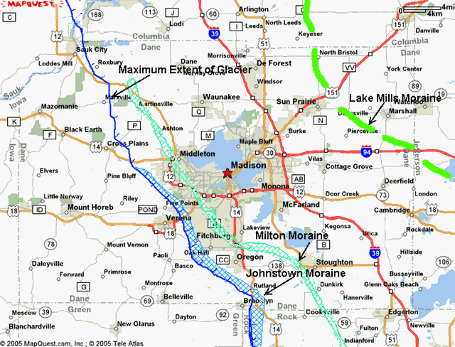
The Wisconsin Glacier began to advance into Wisconsin about 25,000 years ago. It reached its maximum advance about 20,000 years ago and began to melt away about 15,000 years ago. This melting took about 5,000 years to complete. However, the process was not uniform. The glacier likely went through a series of retreats, stalls, and re-advancement. The Johnstown Moraine is a terminal moraine, that is it represents the maximum advancement of the glacier. Just 2-3 miles to the north is the Milton Moraine, a recessional moraine formed during one of the glacial stalls. Much further north and east is another recessional moraine--the Lake Mills Moraine, which is poorly represented in Dane County.
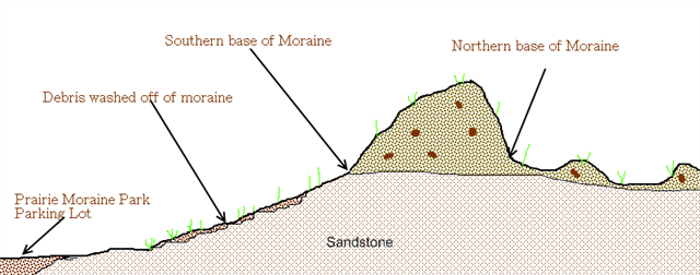
To log this cache email me your your estimate of the height of the Moraine. Keep in mind that the moraine is resting a top a pre-existing ridge and the south slope of this ridge experienced erosion from the outwash of the melting glacier. For the purposes of this earthcache it maybe assumed that County Highway PB cuts through the moraine from top to bottom, and the roadbed is at the level of the pre-existing ridge.
References
Lee Clayton and John W. Attig, Pleistocene Geology of Dane County, Wisconsin. Wisconsin Geological and Natural History Survey, Bulletin 95. Madison: University of Wisconsin, Extension, 1997.
Robert H. Dott and John W. Attig, Roadside Geology of Wisconsin. Missoula, Montana: Missoula Press Publishing Company, 2004.
David M. Mickelson, Landscapes of Dane County, Wisconsin. Wisconsin Geological and Natural History Survey, Educational Series 43. Madison: University of Wisconsin, Extension, 2007.
David M. Mickelson, Louis J. Maher Jr., and Susan L. Simpson. Geology of the Ice Age National Scenic Trail. Madison: The University of Wisconsin Press, 2011.
This earthcache is located in Prairie Moraine County Park. Permit for placement has been approved by the Dane County Parks Department. A copy of the permit maybe obtained by emailing me at the above link.