A river used to run through it EarthCache
A river used to run through it
-
Difficulty:
-

-
Terrain:
-

Size:  (other)
Please note Use of geocaching.com services is subject to the terms and conditions
in our disclaimer.
The coordinates take you to a bridge view of the once mighty Hocking River, now known as Oxbow Creek. In the early 1970s, the five mile re-channeling and partial relocation of the river, once below you, was completed and all that remains is this peaceful little creek.
Prior to the completion of this project, the Hocking River routinely spilled over and flooded much of Ohio University's West Green visible downhill from where you are currently standing and many low lying parts of Athens. The last great flood prior to the re-channeling occurred in May of 1968 when the river crested at 24.63 feet, which was 8 feet above flood stage.
The Hocking River is over 102 miles in length and it originates in Fairfield County at an altitude of 1050 feet. It flows through seven counties before draining into the Ohio River at Hockingport in Athens County. In the process it descends roughly 478 feet. The Hocking River got its name from native American words for the bottle or gourd shapes that the river formed northwest of Athens. Through the years the Hocking River has been know by many names, with the last two being the Hockhocking and the Hocking.
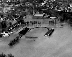
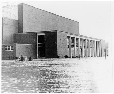
According to FEMA, floods are atop the list of natural disasters in the United States. The cost of the flood of 1968 to Athens County was $8.9 million dollars with $750,000 of damage to the University that surrounds you. The pictures above and below show flooding of structures South of where you are standing. Above is a photo of Peden Stadium in 1968; below is a photo of Grover Center in 1964.
Causes of Flooding:
There are many potential causes of flooding. The following is a list provided by FloodSmart.gov:
- Dam failure
- Flash flooding
- Flooding after a fire
- Heavy rains
- Ice Jams
- La Niña
- Levee failure
- Mudflows
- New development
- Snowmelt
- Spring thaw
- Tropical storms and hurricanes
- Winter rainy season
Flooding may also be caused of a combination of these sources.
Floodplains:
Floodplains are generally described in terms of the likelihood of flooding, which is where we get the term 100-year flood plain. A flood that has a 1% chance (1 in 100) of happening in a given year is known as a 100-year flood. That does not mean that a 100-year flood will only occur once in a 100 year period. It is instead a much more detailed analysis involving probability and statistics. The 100-year floodplain is the area that surrounds the river that is within reach of a 100-year flood.
As you observe the Hocking River below you, you will see the elements of a 100-year floodplain.
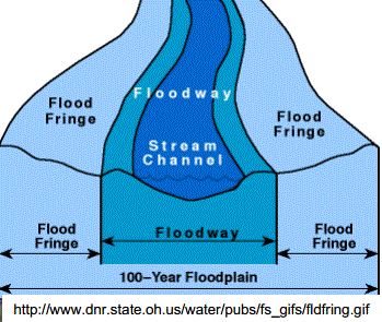
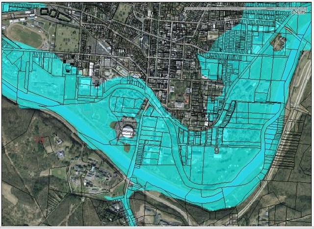
The channel here was manually created as part of rerouting the river. This is where the river normally flows. After heavy rains, the water level will rise above the channel into the floodway. Floodways must remain clear to ensure proper water flow during flooding and development within a floodway is typically restricted by state and local government. The flood fringe is the area adjacent to the floodway which is prone to flooding. Flooding in this area is typically comprised of slower moving or standing water. New construction in the flood fringe typically involves moving a lot of fill dirt to elevate the building site to at least a foot above 100-year flood level. A good example is the basketball arena that you passed as you were walking from Waypoint 1 to Waypoint 2. It was being built during roughly the same time as the river was being rerouted. You'll see it sitting high and dry in the floodplain map below.
In order to successfully log a find for this Earthcache you must fulfill the following requirements. Email correct answers to the following questions to me. Click "Send Message" to start your Email. Do not post your answers in your log.
- At Waypoint 1: In which direction does Oxbow Creek below you flow? (hint: it flows the same direction as the river)
- Looking at the creek below you, you'll make an interesting observation about Oxbow Creek as you look to the eastern side of the bridge. Cross the road carefully. What do you see?
- Walk down the sidewalk towards the Hocking River bridge to Waypoint 2. Here you will find a memorial to a gentleman who worked tirelessly to make this river rerouting happen. What is the formal name given to this waterway on the plaque (i.e. the first two lines on the plaque).
- Walk to Waypoint 3, which will give you a view of the Rerouted Hocking River. Within 50 feet, estimate the width of the floodway below you.
- Finally, use the following web site (http://waterdata.usgs.gov/usa/nwis/uv?site_no=03159500) to look up the current water level and send it in your Email. You are looking for the "Gage height, feet" value.
Congrats to Apparition Cacher for braving the elements for the FTF. Might have been warmer if you had company like Heavy Metal who claimed the STF.
Additional Hints
(No hints available.)
Treasures
You'll collect a digital Treasure from one of these collections when you find and log this geocache:

Loading Treasures