 Grotta Gigante
 The Giant Cave
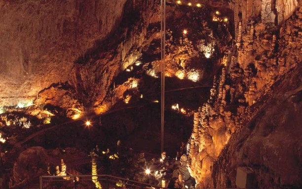
The Grotta Gigante is one of the biggest show caves in the world. Since 1995 the cave is in the Guinness Book of Records as the world's largest tourist cave. In actual fact, the Grande sala, surveyed with the new laser scanning technology, is exactly 167,60 m long, 76,30m wide and 98,5 m high, and has a total volume of 365.000m³. The Giant Cave is characterized by innumerable calcite concretions (stalactites, stalagmites, flowstones), among which it is worth mentioning the 7m high Palma/(Palm) and the Colonna Ruggero(Rüdigersäule), which is 12m in height and has a diameter of 4m. You will notice the changing colors of the rock faces and concretions, which range from bright red to rosy-yellow and pure white.
Grotta gigante is a typical carst cavern. The word ”karst” refers to a type of terrain, usually formed on carbonate rock (limestone and dolomite) where groundwater has solutionally- enlarged openings to form a subsurface drainage system. A mild carbonic acid produced from carbon dioxide in the atmosphere, particularly the soil atmosphere, is primarily responsible for the solvent power of groundwater on carbonate rocks.
The condition for the emergence of caves are water and limestone. The caves develop by intrusion of surface water in fine columns and cracks in the limestone. When the water goes through the humus layers the seeping water takes up carbon dioxide and thereby a weak carbonic acid develops. This enriched water dissolves the limestone and so, very slowly, the cracks and columns get larger and lager.
The cave was first explored by Antonio Federico Lindner in 1840. In those days the Karst behind Trieste was being searched for the underground water of the river Timavo so as to be able to plan the city's aqueduct. In 1897 it was fully mapped by Andrea Perko, in 1905 properly equipped for guided tours and in 1908, inaugurated. After World War I, in the 1920s ownership went to the Commissione Grotte Eugenio Boegan della Societa Alpina delle Giulie (Club Alpino Italiano).
A visit in the cave is always accompanied by a guide and lasts about an hour. The temperature inside the cave is 11°C.
The Giant Cave is opened in October to March from 10 am to 16 pm, in April to September from 10 am to 18 pm.
Closing times: The cave is closed on all non-holiday Mondays from September to June, on September 1st and December 25th.
To visit the cave you have to pay entrance!
To log this earthcache, send email with answers of the following questions and post a photo of yourself (optional) and your GPS at the header coords (the entrance).
1. How many steps are leading to the bottom of the cave?
2. What is the scientifical background for the pendulums?
3.What is the estimated age from the cave?
Don't wait for my log permission!

La Grotta Gigante
La Grotta Gigante grazie alla maestosità della Grande sala viene considerata una delle caverne turistiche più grandi a livello internazionale. Infatti la Grande sala, rilevata con tecnologia laser scanner, misura esattamente 167,60m di lunghezza, 76,30m di larghezza e 98,50m d'altezza, per un volume complessivo di 365 mila m³.
Innumerevoli concrezioni calcitiche (stalattiti, stalagmiti, colate) adornano la grotta. Tra le più interessanti e maestose citiamo: la Palma alta sette metri e la Colonna Ruggero (Rüdigersäule) alta dodici metri e con un diametro di quattro metri.
Da notare il variare della colorazione delle pareti e delle concrezioni che sfuma dal rosso intenso al giallo rosato per arriviare al bianco candido.
La visita alla Grotta Gigante è sempre giudata e vieneeffettuta in circa un'ora. La temperatura all'interno della Grotta è di 11° C constanti per tutto l'arco dell'anno ed il sicuro percorso turistico, realizzato a misura d'uomo, prevede un dislivello di 101,10m.
Orari di vista:
da ottobre a marzo dalle 10:00 alle 16:00,
da aprile a settembre dalle 10:00 alle 18:00.
La Grotta sono chiusi ogni lunedì non festivo da settembre a giugno, il 1 gennaio e il 25 dicembre.
Per registrare questa cache può essere, mi mandi una e-mail con la risposta alle seguenti domande e pubblicare una foto di te (opzionale) e il GPS con l'ingresso della grotta come sfondo:
1. Quanti passi conducono nella grotta?
2. Qual è il sfondo scientifico dei pendoli?
3. Qual è l'età stimata della grotta?
Non c'è bisogno di aspettare per il mio permesso di log!
 Die Riesengrotte
Die Riesengrotte ist eine der größten Schauhöhlen der Erde, seit 1995 ist sie im Guinnesbuch der Rekorde. Der große Dom ist 167,60 m lang, 76,30 Meter breit und 98,50 Meter hoch. Sein Volumen beträgt 365.000 Kubikmeter. Ihre gewaltigen Ausmaße wurden mit modernsten Scannertechnologien genau gemessen.
Erste Erforschungen der Höhle starteten 1840 auf der Suche nach unterirdischen Gewässern und 1908 wurde die Grotta Gigante, damals Riesengrotte genannt, als Schauhöhle für den Tourismus geöffnet. Seit damals stiegen Millionen Besucher bei konstanten 11° Celsius die Stufen zum Höhlenboden hinab, um am Weg die prächtigen Stalagmiten namens Dreizack, Palme, Ruggero-Säule oder Pisa-Turm, die eine Höhe von bis zu zwölf Metern erreichen, zu bestaunen. Die Stalaktiten und die Formationen an den Höhlenwänden erscheinen oft unwirklich, dabei sind es Kunstwerke, die die Natur in Millionen von Jahren geschaffen hat.
Die Grotta Gigante, befindet sich im Triestiner Karst, einem Hochplateau, das sich hinter der Stadt Triest bis zu einer Seehöhe von 400 Metern erstreckt.
Der Karst besteht in seiner Gesamtheit aus karbonatischem Kalk- und Dolomitstein, dessen wichtigste Eigenschaft seine Löslichkeit in meteorischem Wasser ist. So entstand auch die Grotta Gigante vor zig Millionen Jahren.
Am Beginn des Aufstiegs zum Ausgang der Grotta Gigante passiert man die Bodenstation der mehr als hundert Meter langen geodätischen Pendeln, welche Veränderungen der Erdkruste und die Gezeiten erfassen. Am tiefsten Punkt der Grotte befindet sich auch eine Erdbebenstation, die geschützt von äußeren Einflüssen, der Forschung präziseste Daten liefert. Am Weg zum Ausgang, der zum Teil über gewagte Treppenkonstruktionen erfolgt, spürt man noch einmal den Hauch der Erdgeschichte, bevor man ziemlich blitzartig wieder in der Gegenwart landet.
Öffnungszeiten: April bis September 10.00 - 18.00 Uhr (Führung alle 30 Minuten), Oktober bis März 10.00 - 16.00 Uhr (Führung zu jeder vollen Stunde) . Montags geschlossen, ausgenommen Juli und August.
Eintrittspreise siehe Homepage der Grotte
Um diesen Cache loggen zu dürfen, schick mir eine Email mit der Antwort auf folgende Fragen und poste ein Foto von Dir (optional) und Deinem GPS mit dem Grotteneingang als Hintergrund:
1. Wie viele Stufen führen in die Grotte hinunter?
2. Beschreibe den wissenschaftlichen Hintergrund der Pendel
3. Schätze das Alter der Höhle
Du brauchst nicht auf meine Log-Erlaubnis zu warten.