Park Hours:
9 AM - 5:30 PM Nov - Feb
9 AM - 7:30 PM March, April, Sept, Oct
9 AM - 8:30 PM May - Aug
This is one of the most beautiful areas on the Eno and in the park. While it is remote, it can be a fairly flat hike with some rocky areas and little climbs to get to the cache. Park at the Cole Mill access point in Eno River State Park near the Piper-Cox house. Go down to the Buckquarter Creek trail head and stay left until you get to the footbridge crossing Buckquarter Creek - go over take a left onto the Holdens Mill loop. (If you decided to take a right just after the Buckquarter Creek trailhead, it takes up up along the ridgeline but back down eventually to the footbridge - and if you go straight onto Holdens Mill trail when you cross footbridge, you will have a very good climb up the trail, heading back down the loop and to the cache- note: the earthcache is on the trail so if you see the trail suddenly end at this point from either direction, it does pick back up on either side) - also, bring a lunch, it really is a gorgeous area! And remeber to follow the hiker/cacher code - leave no trace/cito. (And all state park rules - do not take any rocks, disturb any wildlife - but yes, you can fish!)
(Credit to Phil Bradley, North Carolina Geological Survey (NCGS) This information was used from
Using the Eno River State Park Rock Kits prepared by Dalhya Lusk, Eno State Park Intern (Summer 2005) and Phil Bradley, NCGS. @ http://www.ncgeology.com/Eno_interactive_webs/Geologic_Principles_Geologic_story.html
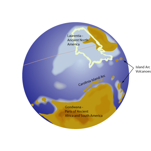
The rocks exposed along the Eno River from the headwaters to West Point on the Eno Park were once part of a volcanic island arc. This volcanic island arc formed off the coast of the ancient continent called Gondwana hundreds of miles from ancient North America (Laurentia). Gondwana included portions of the present day African, South American and Antartica continents. The island arc formed in an oceanic-oceanic crust convergence zone. One oceanic plate was pushed under the other and was forced deep in the earth into the mantle. During the subduction of the oceanic plate a portion of the mantle began to melt. This melting formed magma that slowing rose to near the surface (within 1-5 miles) of the sea floor settling in magma chambers all along the length of the subduction zone.


Some of the magma from the deep seated magma chambers begins to move toward the surface of the ocean floor along cracks (faults and fractures) and is erupted onto the sea floor. These underwater eruptions discharged billions of tons of lava (samples 3 and 4) , ash (samples 2 and 5) and volcanic debris on the sea floor building enormous piles of volcanic debris many 1000’s of feet thick. (Evidence of underwater eruptions are found by the presence of waterlain ash and sediment deposits and the presence of pillow basalts in some areas south of the Eno River.)
The piles of volcanic debris built up high enough that volcanic islands began to break the surface of the ocean. More eruptions followed building the islands larger and larger. (Evidence of above water (subaerial) volcanic eruptions is present as 1) red colored lavas and tuffs– air oxidized (rusted) the iron content of the lavas and tuffs as they erupted on the surface of the volcanic islands and 2) welded tuffs – as hot ash is erupted from the volcanoes the as remains hot enough (>500 degrees Celsius – If the ash was deposited underwater the temperature would not have been able to have remained elevated above 500 degrees Celsius and no welding would have occurred) that when it settles down on the land the ash grains stick to each other and become welded. This produced a very hard rock with distinctive characteristics.
As these volcanic islands emerged above the ocean surface, erosion began working on their destruction. Existing volcanic and intrusive rocks were eroded and the resulting sediment was carried down the steep sides of the volcanic islands into the sea. The eroding of the islands is evident in a rock type named conglomerate (sample 6). Conglomerate is a sedimentary rock that is composed of rounded to partially rounded gravel and sand sized clasts. The clasts in sample 6 consist of tuffs and lavas and granodiorite. At the same time that the volcanoes were eroding, they were still actively erupting ash and lava. As such, the conglomerate and other rocks that indicate erosion are interlayered with the volcanic tuff sand lava flows. Sample 6 was collected from the Wilderness area of Eno River State Park.
Past geologic investigations (Newton, 1983) in the Eno River area have interpreted that the volcanic debris exposed today in the Eno River area was part of a larger volcanic center on top of a large magma chamber. This magma chamber of molten rock may have been at least 27 miles by 8.5 miles in size and may have erupted in great cataclysmic eruptions as the magma chamber emptied of a majority of its contents. The empting of the magma chamber would have formed a large void underground and caused the ground surface to collapse into a great depression called a caldera that would have had similar areal extent as the former magma chamber. The caldera that may have formed after the eruption of the rocks in the Eno River area has been named the Hillsborough Caldera. The ash and volcanic debris ejected from the great eruption rained back down on the land forming thick sequences of volcanic ash and with the debris from subsequent eruptions slowly filled the caldera. The volcanoes that produce large calderas formed after huge cataclysmic eruptions are sometimes called supervolcanoes. The Hillsborough Caldera interpreted to have been at least 27 miles by 8.5 miles was probably to small tohave been considered a supervolcano. Yellowstone National Park sits in a giant caldera that is 47 by 28 miles in diameter. Past eruptions of Yellowstone have been considered as supervolcanoe eruptions.
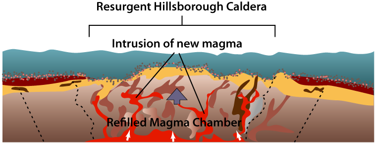
After several hundred thousand years, the Hillsborough Caldera resurged (came back to life). New magma began to enter the former magma chamber, pushing magma up higher into some of the ash and other volcanic deposits from the previous eruptions. (Evidence of resurgence is the presence of large bodies of solidified magma of intrusive rocks called plutons of the rock type granodiorite (sample 7) and diorite (granite-like rocks). The magma intruded the overlying volcanic rocks and cooled very slowly forming individual mineral grains that are visibile with the naked eye. Holden’s Mill, The Sakori and Ridge, and Cox Mountain Trails all traverse over granodiorite and diorite rocks.

The Hillsborough Caldera would have been similar, but smaller in size, to the large (28 mile by 47 mile) Yellowstone Caldera in Yellowstone National Park. The Yellowstone Caldera is in the process of resurging in which water heated by the resurging magma is responsible for the well known geysers (Old Faithful), hot springs, fumaroles, and mud pots. The Hillsborough Caldera, similar to modern day Yellowstone, would have had abundant hot springs were hot water, heated by the magma, circulated through the previously deposited ashes and volcanic debris. The hot spring (hydrothermal) activity extracted silica and other minerals and elements from some rock types or added silica to other rock types forming hydrothermally altered rocks. Evidence of hydrothermally altered rock is present in the pyrophyllite (sample 8) deposits associated with Occoneechee Mountain. At Occoneechee Mountain, hydrothermal fluids removed silica from the ash deposit. The altered ash was later metamorphosed, into the pyrophyllite.
The End of Volcanism in the Hillsborough Caldera Area and the Collision of the Volcanic Island Arc with another Island.
Following the resurgence of the Hillsborough Caldera, volcanic activity appears to have decreased and ended approximately 610 million years ago in the Eno River area. The volcanic islands were eroded and slowly sank beneath the sea.
Around approximately 600 million years ago the volcanic arc that carried the Hillsborough Caldera may have smashed into (interacted with) another island that caused the rocks to be folded and undergo low grade metamorphism (changed through heat and pressure). Known as the Virgilina deformation (Glover and Sinha, 1973), the rocks in the Eno River area were folded into a set of large anticlines and synclines and developed an almost vertical foliation (planar features from metamorphism) (Hibbard et al., 2000). (Evidence of the Virgilina Deformation is the presence of a foliation in many of the volcanic rocks in the Eno River area.)
To log this Earthcache please answer the follwoing questions:
1) Which direction of lava flow do these rocks appear to be going during their formation (use the river as a guide)?
2) Identify at least 2 types of rocks you find at this location (a good guide can be found here http://www.ncgeology.com/Eno_interactive_webs/Virtual_Rock_Kit_Webs/Virtual_Rock_Kit_Main.html)
3) What was the size of the Hillsborough Caldera?
Optional - I love this area and would love to see pictures! Feel free to post as many pictures as you want to make me jealous!
| I have earned GSA's highest level: |
 |