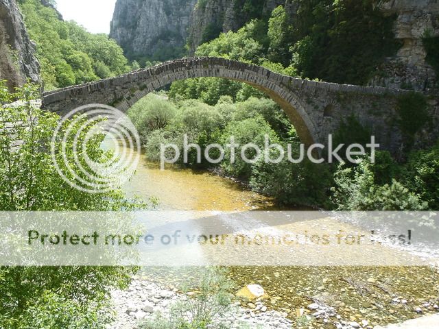
Bridges of Zagori Multi-Cache
-
Difficulty:
-

-
Terrain:
-

Size:  (small)
Please note Use of geocaching.com services is subject to the terms and conditions
in our disclaimer.
This is an "easy" multicache in order to visit some Bridges of Zagori.
Ένα "εύκολο" multicache για να επισκευτείτε μερικά απο τα γεφύρια του Ζαγορίου.

ENGLISH:
Zagori is an area of great natural beauty.
Due to the wild formation of the ground, the climate conditions, the many running waters and also the numerous settlements, the need to interconnect these villages occurred. So a transportation system was constructed that included cobbled footpaths, terraced paths ('skales' in Greek) and stone bridges.
The stone bridges in Zagori are approximately 60, all built between the 18th and the 19th century, in the years of its prosperity, replacing the older wooden bridges. Most of them were built with donations from the rich from Zagori and that's why some of them bear their names.
Many of these bridges are preserved in excellent condition and are visitable. (source www.zagori.info)
We will lead you to some of those bridges. At the final stage you will find a traditional cache container waiting for you!
Answer to Question 1:
Here you are at St.Minas Bridge! This is a single-arced bridge next to the homonymous chapel.
In the front of the chapel you will see a year written on the wall 19AB (see spoiler 1).
Answer to Question 2:
This is Captain Arkoudas Bridge (captain Bear’s Bridge), a single arced bridge 8,5m long and 3,5m high that bridges Xiropotamos river. It was known as Bridge of Xiropotamos or Bridge of the Jew (as a Jew from Ioannina paid for it) but in 1906 the Turkish army killed captain Arkouda there, so it was named after him.
In front of the bridge you will see a gold information plate. An amount is written on it (see spoiler 2) The amount is: 76.CD5 .
Answer to Question 3:
Now you can see a well known bridge , (as the road passes just next to it) between the village Kipous and Koukouli the bridge of Noutsos or Kokkori. It was built in 1750 with funding of Noutsos Kontodimos and rebuilt in 1910 with funding of Gr. Kokkori, has as length of 23.6 m. and height of 8.5 m., while the complete height of the bridge reaches 13 m.
At the coordinates there is a sign (see spoiler 3) According to the sign, how much it takes to walk to Misius Bridge? This is E
How much it takes to walk until Vitsa? This is F
The final cache is at coordinates:
N 39.AB.(963+E) E 020.CD.(316+F)
As the gps signal is really bad in the canyon, please take a look at the spoiler pictures to help you find the cache!  ΕΛΛΗΝΙΚΑ:
Tο Ζαγόρι είναι μια περιοχή με εξαιρετική φυσική ομορφία. Η μορφολογία του εδάφους, οι κλιματολογικές συνθήκες, τα πολλά τρεχούμενα νερά αλλά και η ύπαρξη πολυάριθμων οικισμών, γέννησε της ανάγκη σύνδεσης των χωριών μεταξύ τους. Έτσι δημιουργήθηκε ένα σύστημα επικοινωνίας που περιλάμβανε λιθόστρωτα μονοπάτια, «σκάλες» και πέτρινα γεφύρια.
Περίπου 60 είναι τα γεφύρια στο Ζαγόρι, όλα κατασκευασμένα τον 18ο και 19ο αιώνα, την περίοδο δηλαδή της ακμής του Ζαγορίου, αντικαθιστώντας τα παλαιοτερα ξύλινα γεφύρια. Τα περισσότερα κατασκευάστηκαν με δωρεές πλουσίων Ζαγορισίων και γι' αυτό φέρουν και το όνομα τους.
Πολλά γεφύρια διατηρούνται σε άριστη κατάσταση και είναι επισκέψιμα. (Πληροφορίες: www.zagori.info)
Θα σας οδηγήσουμε σε μερικά απο αυτά τα γεφύρια. Στο τελικό στάδιο θα βρείτε μια "κλασική" κρύπτη να σας περιμένει!
Απάντηση στην Ερώτηση 1:
Βρίσκεστε στο Γεφύρι του Αγίου Μηνά! Ένα μονότοξο γεφύρι δίπλα στο ομώνυμο εκκλησάκι.
Στον μπροστινό τοίχο της εκκλησίας υπάρχει μια πλάκα με μια χρονολογία 19AB (δες spoiler 1).
Απάντηση στην Ερώτηση 2:
Αυτό είναι το γεφύρι του καπετάν Αρκούδα, ένα μονότοξο γεφύρι με μήκος 8,50 μ. και ύψος 3,50 μ. Γεφυρώνει τον Ξηροπόταμο και διατηρείται σε καλή κατάσταση. Κατασκευάστηκε το 1806 και παλαιότερα ονομαζόταν «γεφύρι του Ξηροποτάμου» ή «γεφύρι του Εβραίου», επειδή την κατασκευή του την είχε χρηματοδοτήσει κάποιος Εβραίος από τα Γιάννενα. Στις 6 Αυγούστου του 1906, ο Τουρκικός στρατός σκότωσε στο σημείο αυτό τον Σαμαρινιώτη μακεδονομάχο Καπετάν Αρκούδα και από τότε το γεφύρι πήρε το όνομά του.
Μπροστά από τη γέφυρα θα δείτε μια χρυσή πλάκα με πληροφορίες. Ένα ποσό αναγράφεται στην πλάκα (δες spoiler 2). Το ποσό είναι: 76.CD5.
Απάντηση στην Ερωτηση 3:
Tώρα βλέπετε ένα γνωστό γεφύρι (αφού ο δρόμος περνά ακριβώς δίπλα του) ανάμεσα στα χωριά Κήποι και Κουκούλι, του Νούτσου ή Κόκκορη. Χτισμένο το 1750 με χρήματα που διέθεσε ο Νούτσος Κοντοδήμος και ανακατασκευασμένο το 1910 με χρήματα του Γρ. Κόκκορη, έχει μήκος 23,6 μ. και ύψος 8,5 μ., ενώ το ολικό ύψος της γέφυρας φτάνει τα 13 μ.
Στις συντεταγμένες θα δείτε μια πινακίδα (δες spoiler 3). Σύμφωνα με την πινακίδα, πόσα λεπτά είναι η διαδρομή μέχρι την Γέφυρα του Μίσσιου? Αυτό είναι το E.
Πόσα λεπτά είναι η διαδρομή μέχρι την Βίτσα? Αυτό είναι το F.
Οι τελικές συντεταγμένες είναι:
N 39.AB.(963+E) E 020.CD.(316+F)
ΠΡΟΣΟΧΗ!!!!! EΠΕΙΔΗ ΣΤΟ ΦΑΡΑΓΓΙ ΔΕΝ ΕΧΕΙ ΚΑΛΟ ΣΗΜΑ ΤΟ GPS, ΔΕΙΤΕ ΤΗΝ SPOILER ΦΩΤΟΓΡΑΦΙΑ!!!!!
Additional Hints
(Decrypt)
Nsgre gur oevqtr, ng gur onfr bs n gerr, haqre fbzr fgbarf.