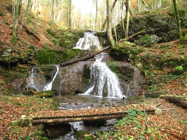
Potok Bajdinc izvira pod Sv. Ahacom in se zajeda v ozko in precej globoko grapo, v kateri ustvarja mnogotero šumov in skočnikov, pa tudi štiri manjše slapove. Obisk potoka je idealen za popoldansko "polnjenje baterij" v zelenju, šumenje vode pa pomiri še tako nemiren duh.
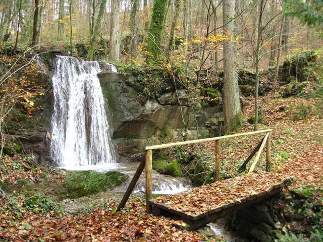
Bajdinški slapovi si sledijo od doline Želimeljščice proti regionalni cesti Ljubljana - Kočevje. Prvi, najnižji slap pada v dveh stopnjah približno 8 metrov globoko. Pri drugem slapu se voda stopničasto v več pramenih spusti slabih 10 metrov globoko. Po grapi navzgor sledi manjša uravnava, kjer je ob potoku tudi opuščen mlin. Kmalu nad njim sta tretji in četrti slap, oba visoka približno 5 metrov. Pri tretjem slapu pada voda ob strmi steni v dveh pramenih v tolmun; stene so debelo obložene z lehnjakom in preraščene s temnozelenim mahom.
Zaklad se nahaja blizu tretjega in četrtega slapu, na nekoliko izpostavljeni točki. Po najdbi zaklada se lahko lotite raziskovanja bližnje okolice, ki je zelo slikovita, posebej po večjem deževju. Popoldanski izlet pa si lahko podaljšate tudi z obiskom bližnjega Turjaškega gradu (GC23HJF), Starega gradu Turjak (GC3EBPP) ali pa vzponom na Sv. Ahac (GC1ZQ4C).
Pot ob zgornjih slapovih ni zahtevna, potrebna pa je primerna pohodna obutev.
Če pa se boste odločili spustiti tudi do drugega in prvega slapu, postane teren veliko zahtevnejši, v mokrem vremenu tudi nevaren, saj so poti zelo spolzke!
Hkrati prosiva, da se izogibate brskanju po razvalinah starega mlina in drugih objektov, ker so v zasebni lasti!
[ENG]
The creek Bajdinc has its source under the hill of St. Ahac and extends into a narrow and deep ravine, where the creek flows over many jumps and also forms four waterfalls. A visit to this place is ideal for an afternoon "charging" in the green surroundings, where the sound of the water soothes even the most restless spirit.
The waterfalls are situated along the Bajdinc Creek from the bottom of the Želimeljščica valley up to the regional road Ljubljana - Kočevje. The first waterfall in the lowest part of the ravine falls in two stages and is about 8 metres high. The second waterfall falls in several strands and is 10 metres high. Continuing up the ravine the surroundings become flatter, and we can find an abandoned mill alongside the creek. Very close to it are the third and fourth waterfall, each measuring about 5 metres in height. The third waterfall drops its water over a steep wall in two strands into a pool; its walls are covered with thick tufa and overgrown with dark green moss.
The cache is located near the third and fourth waterfalls. After finding the cache you can explore the very picturesque surrounding area or visit the nearby Turjak Castle (GC23HJF), Old Turjak Castle (GC3EBPP) or climb up to the hill of St. Ahac (GC1ZQ4C).
The trek to the cache is not very difficult, but suitable hiking shoes are recommended.
If you decide to climb down the ravine to the second and first waterfall, the terrain becomes much more difficult, even dangerous, especially in wet weather, when it is very slippery!
At the same time we would like to ask all geocachers to avoid searching through the ruins of the old mill since they are private property!
 Vir: Kušlan, Rok: Slapovi, Ljubljana: Sidarta, 2008.