[NL]
Dwars door het vlakke meetjesland loopt een heuvelachtig gebied, de cuesta van het Meetjesland. Deze cuesta, die het Maldegemveld overlapt, is één van de traditionele landschappen in Vlaanderen.
Een cuesta is een assymetrische berg of heuvel. De helling is aan 1 kant veel steiler dan aan de andere zijde.
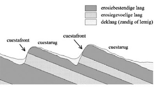
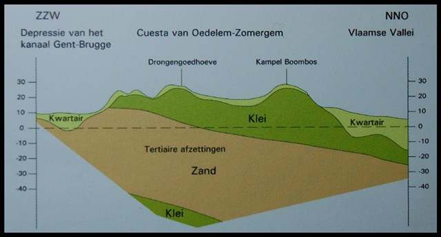
De cuesta van het Meetjesland is ontstaan in het tertiair (2 miljoen jaar geleden). Toen werden afwisselend harde (klei) en zachte (zand) grondlagen afgezet door de zee, die onze gewesten overspoelde vanuit het noorden.Door de opstuwing van de tektonische plaat in het zuiden, komt er een neerwaartse helling van Zuid naar Noord. Hierdoor hellen de grondlagen van de cuesta van noord naar zuid af. Tijdens het quartair (vanaf 2 miljoen jaar geleden tot nu) werden deze lagen uitgesleten. De erosieprocessen hadden relatief gezien veel minder vat op de harde kleilagen dan op de zachtere en losse zandlagen. Hierdoor bleven de harde grondlagen hoger uitsteken tegenover de rest van het landschap. Het resultaat van dit proces is een cuestafront met toppen tot 30 meter en ten noorden en zuiden ervan een vlak opgevuld landschap: de Vlaamse Vallei en de Depressie van het kanaal Gent-Brugge.
Eeuwenlang strekte zich hier een immens onherbergzaam hiedegebied uit. Heide komt immers vooral voor in arme en zure gronden. De grond aan de cuesta bestaat uit een dikke kleilaag met slechts een dun laagje zand. Dit is een typische grond voor de heide. In de 18de eeuw werd het landschap grondig gewijzigd en werd het heidelandschap omgevormd in wat nu het grootste aaneengesloten bosgebied van Oost-Vlaanderen is: het Drongengoedbos. Naast het drongengoedbos ligt het natuurgebied Maldegemveld. In dit gebied probeert Natuurpunt de natuurlijke heidevegetatie opnieuw een kans te geven. Dit herstelbeheer krijgt ook bijzondere aandacht door middel van het LIFE+ natuurfonds van Europa. Het Maldegemveld en het Drongengoedbos behoren immers tot het NATURA 2000 netwerk, het Europees netwerk van beschermde natuurgebieden in Europa.
Maak dus van de gelegenheid gebruik om een wandeling te maken in dit uniek stukje natuur.
De hellingen in het landschap verwijzen naar de cuesta. Bovendien kun je hier de typische vegetatie van de cuesta bewonderen.
Om deze cache te loggen dien je volgende vragen op te lossen op de bovenstaande coördinaten:
- Tot welke hoogte loopt de cuesta van het Meetjesland op volgens het infobord op wp 1?
- Op deze arme, zure gronden komt specifieke vegetatie voor. Op het infobord zie je een foto van 1 van deze planten. Welke?
- Bekijk het landschap in de buurt van wp 2. Sta je hier op een cuestafront of een cuestarug? Leg uit waarom dit zo is.
- Op wp 2 zie je de heide groeien. Geef op basis van deze vaststelling aan of je hier op een zand of klei gedeelte van de cuesta staat.
- Neem een foto van jezelf in het Maldegemveld en voeg deze bij aan je log. (optioneel)
Opgelet: Om geldig te loggen moet je per nickname elke vraag beantwoorden en deze naar ons mailen, voor of tijdens te loggen. Logs zonder mail (of waarbij niet alle vragen beantwoord worden) worden verwijderd! Speel het spel eerlijk en bezoek de locatie om de vragen te beantwoorden.
1 nickname = 1 mail met antwoorden = 1 log
MAIL de antwoorden naar ons door. (geen antwoorden sturen via het Message center.)
Op bovenstaande coördinaten is een ruime parking voorzien. Zie additional waypoints voor de ingang van de parking
[EN]
Across the flat Meetjesland is a hilly area, the Cuesta of Meetjesland. This cuesta, that overlaps Maldegemveld, is one of the characteristic landscapes in Flanders.
A cuesta is an asymmetric mountain or hill. The slope is much steeper on one side than the other.
The Cuesta of Meetjesland was formed in the Tertiary (2 million years ago). At that time hard (clay) and soft (sand) ground layers were deposited by the sea, that flooded our continents from the North. The impoundment of the tectonic plate in the south caused a downward slope from south to north. Because of this the ground layers of the cuesta slope down from north to south. During the quaternary (from 2 million years ago till now) these layers wore out. The erosion processes had relatively less grip on the hard clay layers than on the softer en loose sand layers.
This caused the hard ground layers to stick out higher than the rest of the landscape. The result of this process is a cuesta front with tops as high as 30 meters and north and south of them a flat filled landscape: the Flemish Valley and the depression of the canal Gent-Brugge.
For centuries a huge and inhospitable moorland stretched out. Heath is found on poor and sour soil. The soil from the cuesta exists of a thick layer of clay covered with just a thin layer of sand. This is a typical soil for the moorland. In the 18th century the landscape was modified greatly and the moorland changed in what is now the biggest enclosed woodland of East-Flanders: the Drongengoedbos. Next to the Drongengoedbos is a nature reserve called Maldegemveld. In this area Natuurpunt is restoring the moorland. This management is given extra attention from the LIFE+ nature fund of Europe. The Maldegemveld and Drongengoedbos are part of the NATURA 2000 network, the European network of protected nature reserves in Europe.
So take the opportunity to make a walk in this unique piece of nature.
The slopes in the landscape refer to the cuesta. You can also admire the typical vegetation of the cuesta.
To log the geocache, answer the following questions at the coordinates above:
- How high is the highest part of the cuesta of Meetjesland, according to the infosign at wp 1?
- On this poor, sour ground some special vegetation grows. On the info sign you can see a photo of one of these plants, wich one?
- Look at the landscape around waypoint 2. Are you standing on a cuestafront or a cuestarug? Explain why.
- In the text above it is mentioned that for centuries a large moorland stretched out. At waypoint 2 you can watch the heath grow. Specify, based on this observation, whether you are standing on a clay or sand part of the cuesta.
- Take a picture of yourself in Maldegemveld and add it to your log. (optional)
1 nickname = 1 mail with answers = 1 log
MAIL us the answers. (Don’t sent answers via the message center)
At the coordinates above is a large parking. Look at the additional waypoint for the entrance to the parking