En Inglés (español abajo)
Welcome to the beautiful sand beaches of Bandera Bay. The 2.5 difficulty rating is for the long length of the description. Closest access to this beach is from the nearby public parking lot on the south side of the Pitillal River. Paved trail and parking lot is at N 20° 38.739 W 105° 14.286. Part of your short walk will be on the beach.
Getting there/transportation:
Walking from cruise ship: follow the highway to the south side of the river and into the public parking lot. You can also access the beach by the petrol/gas station by the ship marina and walk the beach but you will be on the wrong side of the river from GZ and the nearby traditional cache.
BY BUS: take any blue and white bus that says "Hoteles" in the windshield and is heading in this direction. Best bus stop is south of the TH, so if you're coming from the north (the Marina) stand up and go to the door when the bus is on the bridge over the river. If you are exiting the back door push the red exit button so the driver will know to stop at the next stop. If you are coming from the south (from downtown) start getting off when you're .2 miles from the TH so the bus will stop at the traffic light 1 block south of the TH. Bus fare as of January 1, 2018 is 7.5 pesos (less than $1.00 U.S.).
BY TAXI: take a taxi to the beach by the Pitillal River near SunScape Hotel (but don't go into the hotel, it's gated. 1/2 block to trailhead). All taxi drivers know the SunScape but may not know the beach access. Taxis have flat rates based on zones so you can ask how much before you go. Taxi rates from federal properties, ship marina and airport, are different from rates for taxis on the street.
The earthcache lesson and description:
Rio Pitillal (Pitillal River) brings sand, silt and small rocks down from the mountains. Other sand is brought along the coast (beach). The size of material brought down by the river depends on the speed of the water and the turbulence of the flow, with higher water speed and more turbulent flow bringing more material and larger sand and rocks than slow water or laminar flow:

The bed load: coarser and denser particles that remain on the bed of the river most of the time but move by a process of saltation (jumping) as a result of collisions between particles and turbulent eddys:

When the river reaches the ocean the river current tends to slow down and the particles are deposited. Observe the formation of any berms, sand bars or banks that have been built up by wave action. Large waves cause the sand to wash out to sea and small waves build up the beach.
Sand is also brought here by beach drift. Beach drift is due to waves approaching at angles to the beach but washing back into the ocean at right angles. The sand moves along in a zigzag path. This process moves sand along the beach, including into the mouth of the river.

When the tide rises the water tends to flow up river, temporarily slowing or stopping the river flow and allowing sand to be deposited in the mouth of the river. When the tide goes out the river and lake water tends to rush out and carries a lot more sand and other material with it.
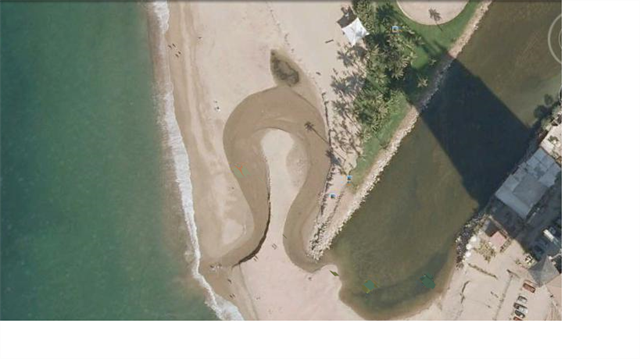
If the incoming tide stops the river long enough and the waves move enough sand the beach can build up a beach berm and block the river and form a lake behind the berm. The river then fills up the lake until it overflows the berm. This overflow can happen directly downstream from the main river channel, or it can happen up to 800 feet down the beach. It can form an S-shape or an Omega shape in the river bed, or it can just go straight out.
Here is an omega shape example from Google Earth in 2009:
Here is how it looked on the morning of Dec. 5, 2012 when the outflow was S-shaped and the mouth was 800’ south and the water was only inches deep:
. . . and on November 24, 2013 with a straight channel and deeper water:
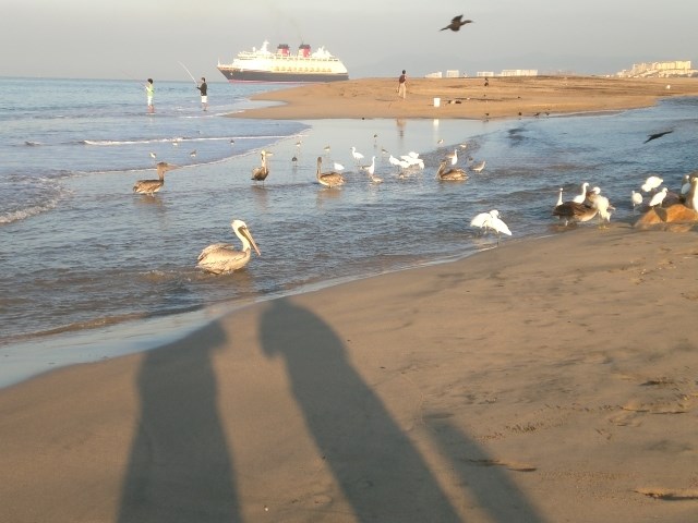
At one low tide I stood at the posted coordinates and watched as young men dug a shallow channel through the beach berm to start the river flowing and the lake draining. Within 10 minutes the channel was 6 feet wide and 2 or 3 feet deep with the water running through it like a mill race. People were jumping in and sliding down into the ocean.
You do not need to get wet to do this earthcache. Be aware of the waves and the river and the danger they may pose. Do not take risks. Stand near the south shore of the river on the dry part of the beach near where the river enters the ocean. Watch people and /or horses cross the river and estimate the depth of the water in the river.
To get credit for your find, answer these questions and email or message me your answers. Do not post them in your log or it will be deleted. Send in your answers about the same time you log your find, not days or weeks later, or I shall delete your log. Thank you!
-
What is the time of day when you are here, local Puerto Vallarta time?
-
What is the depth of the river where it enters the ocean? Use either feet to the nearest 6” (for example, 1.5 feet, 5 feet, etc.), meters to the nearest 1/4 meter, OR use description (ankle deep, chest deep, etc.) If the waves and tide have blocked the river with sand this will be 0.
-
What is the direction of flow of the river (toward the ocean or upstream) and what do you think the condition of the tide is (e.g. high, low, flood or ebbing) and why?
-
What are the coordinates of the south shore where it enters the ocean and/or how far is the mouth from the published coordinates?
-
What is the shape of the 'channel' between the main part of the river and the ocean (examples might be straight, S-shaped or Ω (omega) shaped)? How do you think this shape formed?
-
Bonus: Take a picture of the part of the river that crosses the beach. Suggested places are the high ground of the beach west of the end of the trail, or from the south on the jetty if the river mouth is down that way.
- - - - - - - - - - - - - - - - - - - - - - - - - - - - - - - - - - - - - - - - - - - - - - - - - - - - - - - - - - - - - -
En español (Below is the Spanish version)
Bienvenido a las hermosas playas de arena de la Bahía de Bandera. El acceso a la playa está en el camino pavimentado para bicicletas desde el estacionamiento en el lado sur del río Pitillal. Parte de su corta caminata será en la playa. La calificación de 2.5 dificultad es la longitud de este Caché Tierra. A principios de 2014, para llegar hasta aquí tome un taxi hasta el exterior del Holiday Inn o tome cualquier autobús azul que dice "Hoteles" en el parabrisas y se encamina en esa dirección, ya sea del Marina o del centro de (Centro), y bajar en el semáforo una cuadra al sur del sendero (cerca del Holiday Inn).
Río Pitillal trae arena, limo y pequeñas rocas de las montañas. Otras arena se lleva a lo largo de la costa (playa). El tamaño del material traído por el río depende de la velocidad de la agua y la turbulencia del flujo, con una mayor velocidad en el agua y el flujo más turbulento traer más material y mayor arena y rocas que el flujo de agua lento o laminar:
La carga de fondo: más grueso y las partículas más densas que permanecen en el lecho del río la parte mayor del tiempo, pero se mueven por un proceso de saltacion (saltar), como resultado de colisiones entre partículas y remolinos turbulentos:
Cuando el río llega al mar la corriente del río tiende a reducir la velocidad y las partículas se depositan. Observar la formación de las bermas, bancos de arena o los bancos que han sido construidas por la acción del oleaje. Grandes olas hacen que la arena para vaciar en el mar y las olas pequeñas se acumulan la playa.
La arena también se ha traído aquí por la deriva de la playa. Deriva Beach es debido a olas que se aproximan a los ángulos de la playa pero que lavan de nuevo al océano en ángulo recto. La arena se mueve a lo largo de una trayectoria en zigzag. Este proceso mueve la arena a lo largo de la playa, como en la desembocadura del río.
Cuando sube la marea la agua tiende a fluir río arriba, ralentizando o deteniendo temporalmente el flujo del río y permitir la arena que se deposita en la boca del río. Cuando baja la marea del río y el lago de agua tiende a salir corriendo y lleva mucha más arena y otros materiales con los que.
Si la marea entrante se detiene el río el tiempo suficiente y las olas se mueven suficiente arena de la playa se puede construir una berma de playa y bloquear el río y formar un lago detrás de la berma. El río entonces se llena el lago hasta que rebose la berma. Este desbordamiento puede pasar agua directamente abajo del canal principal del río, o puede ocurrir hasta 250 metros por la playa. Puede formar una forma de S o una forma de Omega en el lecho del río, o simplemente puede ir en línea recta.
Aquí hay un ejemplo de forma de omega de Google Earth desde 2009:
Este es el aspecto que tenía en la mañana del 5 de diciembre de 2012, cuando el flujo de salida fue en forma de S y la boca era de más de 250 metros de distancia. Fue sólo centímetros de profundidad:
. . . y el 24 de noviembre de 2013, con un canal recto y aguas más profundas:
En una bajamar me paré en las coordenadas publicadas y vi como los hombres jóvenes cavaron un canal poco profundo a través de la playa de la berma para iniciar el río que fluye y el drenaje del lago. Dentro de los 10 minutos, el canal fue de 6 metros de ancho y 2 o 3 metros de profundidad con la agua corriendo a través de ella como una carrera de molino. La gente saltaba y deslizarse hacia el océano.
No es necesario que se moje para hacer este Caché Tierra, Earthcache. Esté al tanto de las olas y el río y el peligro que pueden representar. No tome riesgos. Párese cerca de la orilla sur del río, en la parte seca de la playa, cerca de donde el río entra en el océano. Observe a las personas y / o caballos cruzan el río y estimar la profundidad del agua en el río.
Para obtener crédito por su hallazgo, responder a estas preguntas y me envíe sus respuestas. No publicarlos en su registro o será eliminado. Envíe su correo electrónico sobre la misma vez que se conecte a su descubrimiento, no en días o semanas más tarde, o que deberá eliminar el registro. Gracias!
-
¿Cuál es el momento del día en que usted está aquí, hora local de Puerto Vallarta?
-
¿Cuál es la profundidad del río donde entra en el mar? (por ejemplo, 1/4 metros, 1/2 metros, 2 metros, etc) Si el río está bloqueado por un banco de arena, use cero.
-
¿Cuál es la dirección del flujo del río (hacia el océano o aguas arriba) y qué opinas de la condición de la marea es (por ejemplo, alto, bajo, inundación o reflujo) y por qué?
-
¿Cuáles son las coordenadas de la costa sur donde entra en el océano y qué distancia hay entre las coordenadas publicadas?
-
¿Cuál es la forma del "canal" entre la parte principal del río y el océano (ejemplos podrían ser recta, forma de S o Ω (omega) en forma)? ¿Cómo crees que esta forma formado?
-
Opcional: Tome una fotografía de la parte del río que atraviesa la playa. Lugares sugeridos son las tierras altas de la playa de poniente de la final de la pista, o desde el sur por el muelle si la boca del río es en esa dirección.