Old D&S Rwy (MP 40.4): Angier Depot Mystery Cache
RR-Bob: No longer geocaching. Cache is still in place if someone wants to take it over.
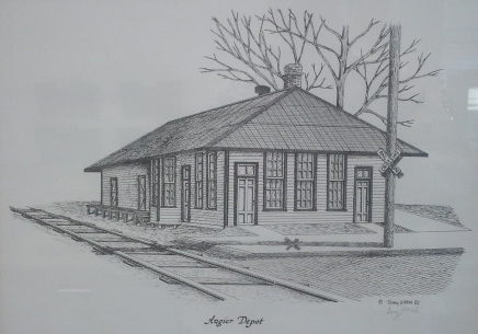
Old D&S Rwy (MP 40.4): Angier Depot
-
Difficulty:
-

-
Terrain:
-

Size:  (small)
Related Web Page
Please note Use of geocaching.com services is subject to the terms and conditions
in our disclaimer.
This multiple stage cache hunt is designed to remind you of the impact that a small regional rail line like the Durham & Southern Railway made on towns all along this route between Durham and Dunn, especially Angier. On-site calculations will be required, and for those without smart phones, additional resources may also be required to convert GPS coordinates into another format, thereby increasing the difficulty level.

Historical Narrative:
Before Angier was on a map, Jake Williams' farm brought the railroad to this area in 1899. The railroad was little more than a tramway leading from Apex, in Wake County, to the Jake Williams' farm in Harnett County. It was first known and chartered as the Cape Fear and Northern Railroad; later, about 1906, the line was extended to Durham and the name changed to the Durham and Southern.
The purpose of the railroad was to haul lumber and logs. The area around Angier had a vast sweep of fine saw timber, from short and long straw pines. The trees had been bled by the turpentine workers, leaving long stems of southern pine ready to be cut and sawed into lumber. When the turpentine business came to an end, workers and their families moved south to find un-bled timber; and a new era began. A new way of making a living and supporting a family began-saw milling. No longer was the ox cart and mule-drawn wagon efficient to move lumber and logs. Now the building of the railroad was hailed as a step forward. Farming was becoming more important; growing cotton and tobacco took the place of sawmill work as that era came to a close.
The late Col. Johnathan Cicero Angier, who married the niece of the late Washington Duke, owned and operated a lumber plant in Cary and decided to build a railroad down along the pine ridge from Apex to Harnett County. Supposedly with the backing of the Dukes, he built a railroad to the farm of Jake Williams where a "Y" was also built for turning the engine around. In time, a station house was erected for the train crew to stay at night and daily round trips were made to Apex.
Jake and his son Benton operated a general store and a turpentine distillery. Goods were transported to and from Raleigh or Dunn by two or four-horse wagons. The coming of the railroad was a boon to farmers, merchants and lumbermen.
After much discussion and numerous suggestions, the station house was named Angier to honor Johnathan C. Angier who played a major part in bringing the railroad to the area.
In July 1899, Jake Williams secured a noted surveyor, Daniel E. Green, to map and plot the land surrounding his home and the newly erected depot. Streets were laid off and named and Angier had its beginnings. By act of the North Carolina Legislature of 1901 the town received its charter.
In 1959, the Durham & Southern Railway made two stops in Angier daily. The northbound freight from Dunn stopped here at 10:15 am and the southbound train stopped here at 2:25 pm. The Angier station was located at Milepost 40.4 on the route from Durham to Dunn.
During the 1930's, The Angier Woman's Club undertook a project to have crepe myrtles planted on roadsides leading into town from all directions. The trees make a spectacular show during June, July and August. The town chose "The Town of the Crepe Myrtles" as its slogan. Every year a Crepe Myrtle Festival is held in September with food, crafts and entertainment for all.
The Durham and Southern railroad, which had run through the center of town since 1899, had its last run from Apex to Dunn on July 5, 1979. No longer was the railroad the cheapest way to transport goods to and from the industries of Angier and was no longer realizing a profit. Mayor Jack Marley and other town officials requested that railroad officials donate to the town the depot and the one hundred foot right of way within town limits. That was done and so ended another era.
The historic Angier Depot now survives as the Chamber of Commerce, with the SCL 1083 caboose on the other side of the park from it. For its 100th anniversary, North Carolina Senate Joint Resolution #254 paid tribute to the founders of the town of Angier.
Now on to the cache:
The starting coordinates for this multi-stage Mystery Cache bring you to the flagpole at Charles Nordan Square along Centennial Walkway in downtown Angier in front of the Town Hall.
Step 1. The first step you need to do is convert the GPS coordinates of the starting flagpole location into decimal degree coordinates for both the latitude and longitude (i.e. DDD.DDDDDD format), disregarding the westerly "negative" connotation in the longitude in the mathematical calculations.
Step 2. Next, you will need to locate two waypoints near the starting coordinates to calculate and locate the final cache location. You can easily walk to the two waypoints, both north and south of the flagpole, along the walkway (which was constructed over the former D&S Railway mainline trackbed) to obtain the necessary information to calculate the actual cache location.
a. The first waypoint about 121 feet north of the flagpole is a plaque describing a memorial fountain. Calculate the location into the decimal degree GPS and write it down.
b. The second waypoint is a plaque describing the Centennial Clock and is located about 144 feet south of the flagpole. Write down the decimal degree GPS location as well.
Step 3. The next steps will calculate the actual cache location.
a. Subtract the 2nd waypoint latitude from the 1st waypoint latitude. Add 678 to the result from the decimal degree latitude of the Flagpole coordinates at the starting point (using the six digits to the right of the decimal). The result will be the latitude coordinate of the final cache location (in decimal degree format).
b. . Subtract the 1st waypoint longitude from the 2nd waypoint longitude. Add 494 to the result from the decimal degree longitude of the Flagpole coordinates at the starting point (using the six digits to the right of the decimal). The result will be the longitude coordinate of the final cache location (in decimal degree format).
c. Convert the decimal degree coordinates for both latitude (Step 3a) and longitude (Step 3b) into GPS coordinates (DDD MM.MMMM).
d. Proceed to the coordinates calculated for the final cache location.
You can verify your calculations at the GeoCheck link below.

This entire cache challenge can be walked easily, but, as you can see, the steps may require calculations that you may or may not be able to do on-site. Please be aware that while your on-site exploration can be explained as a tourist for the most part, muggles are likely to be present throughout your adventure because it is in the center of the small town of Angier.
Additional Hints
(Decrypt)
TRY IT FIRST WITHOUT LOOKING AT THIS SPOILER!
Uvag bayl sbe Natvre Ovxr Srfg Pryroengvba ivfvgbef guvf jrrxraq: FJ pbeare bs pnobbfr.