The River Lune Millennium Park and Cycle Way stretches some 15km along the line of the former "Little" North Western Railway branch line that once connected Wennington to Morecambe via Salt Ayre as part of NWR's main line operation between London St Pancras and the Heysham Packet Boat terminal. The stretch of the old railway line between Green Ayre and Caton was paved and lit (as far as Station Yard, Caton) as part of a Millennium project undertaken jointly by Lancaster City Council, Lancashire County Council and The Millennium Commission. Although, the lights (thankfully) do not extend beyond Station Yard, the paved way extends a little way beyond the Bull Beck picnic site, becoming very close to the river and with fine views across it is it bridges Bull Beck.
This route between Lancaster and Caton (and beyond) is a good way to see some interesting features as well as wildlife on and around the river, throughout the year. There are various points of access to it from the main Lancaster - Kirkby Lonsdale road (A683) if you don't have the time or energy to venture along the whole pathway.
The Weird...
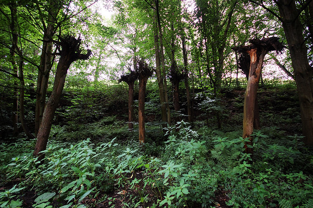
Close by the cache site there used to be the rather weird sight of a number of branchless larch tree trunks, with their tops firmly planted in the ground and their roots waving in the air. This was a sculpture by Giles Kent, imaginatively entitled "Upside Down Trees". It was commissioned together with a number of other art works as part of the establishment of the Millennium Park, in 2000. Owing to its deteriorated state, the sculpture was declared unsafe in late 2012, and was subsequently cut down by the Lancaster City Council. Its rather inelegant remains can still be found just to the south of the walkway. Few people mourn its passing.
...the Weir
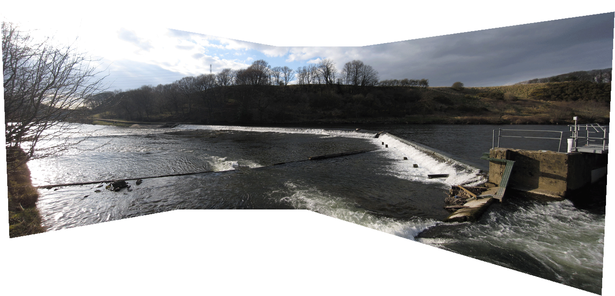
There have been weirs along the river between Skerton and Caton for hundreds of years, most designed to regulate water levels in the river, both for year-round water extraction and for management of fishing. Forge Weir is the most upstream of these, and was most probably originally constructed to provide a source of water for mills at Halton, a little way further downstream on the north (right) bank of the river. Its current name suggests its association with Forge Bank Mill, a cotton-spinning mill, built some time round about 1820 by Thomas and Edward Atkinson of Holme Mills. The nineteenth century mill took its name from the fact that it was constructed on the site of a former eighteenth century iron forge, itself believed to have been converted briefly into a cotton mill, suggesting that there was originally a weir at this site from even earlier.
The current weir is a concrete and stone V-shaped structure, used primarily to regulate water depth and flow in the river but also acting to monitor and record local fish migrations. Remains of the old leat (mill-race) off-take are visible at the far (northern) end of the weir. The former head-race that ran from there to Forge Bank Mill has long been filled in, however. The new eco-housing development at the old mill location have applied for permission to install a hydro-electric scheme utilising the old leat off-take and discharging back into the river a little way downstream.
The more noticeable features of the weir from the cache site, however, are the two fish passes which allow migrating fish to safely navigate the weir in both directions. The main fish pass is located at the southern end of the weir, adjacent to the left-hand bank of the river and consists of two large pools, formed by diagonal walls running between the weir and the true river bank, and connected by a pair of sloping 2m-wide channels which by-pass the weir alongside the river bank. These channels contain a series of resistivity measuring electrodes over which migrating fish have to pass, enabling their size, direction of travel and even type to be measured and monitored. In addition, a further secondary fish pass has been incorporated at the apex of the "V", in the middle of the river channel, where the normal crump profile of the weir crest has been modified though extension into a 20% down-stream slope, over which the river water flows as a shallow sheet. The flow of water through both passes is regulated to maintain a high enough rate to attract salmonid fish migrating upstream, whilst the two channels of the main pass extend 12m upstream of the weir to form a lead-in channel for fish migrating downstream.