Note: This is an Earthcache. There is no physical cache to find. Logging this Earthcache requires that you undertake an educational task relating to the specific Earth Science at the site.
Prior to logging this cache, click on Message this owner, or send an email with answers to the following questions:
- During the rainy months, the Hillsborough River receives its water from the Green Swamp and Crystal Springs. Water coming from the Green Swamp is a dark, tea color from the tannin that leaches from the leaves of the trees. During the dryer winter months, Crystal Springs’ clear water provides the major supply of water to the Hillsborough River. On a scale of 1 to 10, 1 being crystal clear, state the clarity of the water.
- Based on the clarity, where do you think the majority of the water is coming from: Green Swamp or Crystal Springs?
- There are resurrection fern on the cypress tree that overhangs the suspension bridge. They are an indicator of recent rainfall. Do they look fresh and alive, or do they need watering?

- Required to log this cache: Please provide a photo of yourself or a personal item in the picture to prove you visited the site. Upload the photo with your log.
Hillsborough River State Park
This EarthCache is located in Hillsborough River State Park (HRSP). An entry fee is required. HRSP is one of the earliest state parks in Florida. The suspension bridge at GZ was built by the CCC between 1934 and 1936. In the 1940's, the swimming beach was on the opposite bank from the Rec. Hall. The lifeguards would signal for everyone to get out of the water when an alligator was going to pass through. The swimmers were allowed back in the water after the alligator passed. In 1979 the river was closed to swimming due to high coliform levels, not the presence of alligators.
Watershed
Webster’s dictionary defines a watershed as “a region or area bounded peripherally by a divide and draining ultimately to a particular watercourse or body of water”. We’re all familiar with the Continental divides in the US. Most of us have crossed either the Eastern Continental Divide (Appalachians) or the Western Continental Divide (Rockies). It’s hard to notice the “divides” in Florida that form the boundary of watersheds.
Watersheds, or drainage basins, are separated from adjacent basins by topographic divides. The Hillsborough River watershed is bounded to the north by the Withlacoochee River watershed, to the east by the Peace River watershed, to the south by the Alafia River watershed, and to the west by the North Coastal and Tampa Bay watersheds.
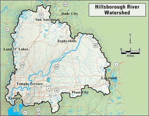
The Hillsborough River watershed covers approximately 690 square miles of west-central Florida. The Hillsborough River is the main waterway of the watershed. It begins in the Green Swamp area of Pasco and Polk counties; as do three other major rivers in Florida: the Withlacoochee, Peace and Oklawaha. After leaving the swamps, the Hillsborough River flows 54 miles southwesterly into Hillsborough Bay.
The average annual precipitation for the Hillsborough River watershed is 51 inches. In dry years it has been recorded as low as 32 inches and in wet years as high as 77 inches. In a typical year, approximately 60 percent of the annual precipitation is produced by thunderstorms during the four-month period between June and September. Normal monthly rainfall is greatest in August (over 8 inches) and least in April (less than 2 inches).
The name Hillsborough River first appeared on a British map in 1769. At the time, the Earl of Hillsborough was the British Secretary of State for the Colonies. In 1995 the Hillsborough River was designated an Outstanding Florida River.
HRSP offers many recreational opportunities including geocaching, hiking, canoeing, fishing, camping, tours of the historic reconstruction of Fort Foster, a 1/2 acre swimming pool (weather permitting) and a Class II river rapids – a rarity in Florida.
Sources: Hillsborough River State Park; Hillsborough River Comprehensive Watershed Management Plan; Hillsborough River Watershed Alliance