
Esker in the Distance
This is a fully Handicap accessable Earth Cache, that can be completed from your Car.
For this Earth Cache you will be visiting 2 locations, but looking at the same thing.
At Waypoint # 1 (The posted Coordinates) you will see this .

And if you look closely enough, you should focus on this.

What your seeing is a Uniformly Tree covered Esker.
I bet you would have never guessed that?
So, just what is an Esker and how did it get here?
(Partly Quoted from the Encyclopedia Britannica)
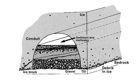
esker, also spelled eskar, or eschar, a long, narrow, winding ridge composed of stratified sand and gravel
deposited by a subglacial or englacial meltwater stream.
Eskers may range from 5 to 50 m in height, from 500 m in width,
and a few hundred feet to tens of km's in length.
The sediment is sorted according to grain size, and cross-laminations that show only one flow direction commonly occur.
Thus eskers are considered to be channel deposits (left by streams that flowed through tunnels in and below the ice)
that were let down onto the ground surface as the glacier retreated.
Esker formation presumably takes place after a glacier stagnates,(Stops Moving)
because movement of the ice would likely spread the material.
An esker is the creation of a stream that flowed inside a glacier, typically at the bottom of a crevasse in the ice.
Glacial ice is full of sediment, rocks, fine clay particles, and plenty of sand and gravel.
The sand and gravel accumulated in these cracks and creveses,
but it was held in on the sides by the ice itself, in other words gradually filling a tunnel in the ice.
When the ice melted, a meandering sinuous ridge of sand and gravel is left across the landscape.
This is what we see today at GZ.
So, Why is this Grove of Uniformed trees here?
Jack pine commonly grows on level to gently rolling sand plains.
It grows best on well-drained loamy sands where the midsummer water table is 4 to 6 feet below the surface.
Jack pine does well on moderately acidic soils, but it will tolerate slightly alkaline conditions.
It grows poorly on shallow bedrock and heavy clay soil. Jack pine survives and grows better than other tree species on dry sandy soils
At Waypoint #2
N 44° 21.180 W 076° 48.783
You will get a close up view of this Esker
DO NOT LEAVE THE ROAD
if fact
THIS WAYPOINT CAN BE DONE FROM YOUR CAR.
If you look closely enough, you can see the end of the Esker,
and proof that this indeed is an ESKER
So, Using the information given above, and using information collected
at waypoint # 1 and waypoint #2 you must answer the following 4 questions
and send the Answers to me, Via my Geocaching profile.
DO NOT INCLUDE THE ANSWERS IN YOU ON-LINE LOG
Once the Answers are sent, please feel free to log this Earth Cache,
I will contact you afterwards, confirming your answers, or assisting you with wrong answers.
Like all my Earth Caches, they are meant to be fun and educational, they are NOT meant
to stress you out getting exact right answers
Coman123
QUESTION #1
At the posted coordinates look at the Grove of trees, Using the information above,
Can you tell direction was the ice moving during the formation of this Esker?
If so, How?
QUESTION #2
At the Posted Coordinates take an altitude reading.
Do you think the bottom of the Esker will be significantly higher then your current location?
Now head to Waypoint #2 and take an altitude reading,
Is the base of the Esker at a significantly higher altitude, or do the tree's create an optical illusion?
(Include both altitude reading's with your answer)
QUESTION #3
At Waypoint #2, what evidence can be seen, that supports that this is an Esker?
Describe what Evidence you see, Terrain, Shape Surrounding area ETC.
QUESTION #4
At Waypoint #2,
What type of operation is, or was happening here?.
Photo's are welcome and encouraged, but not mandatory for
logging this Earth Cache