Blackie Spit Earthcache EarthCache
Please note Use of geocaching.com services is subject to the terms and conditions
in our disclaimer.
Shifting Sands
Lesson adopted from Bob Turner & John Clague, Geological Survey of Canada
The purpose of this EarthCache is to learn about shoreline erosion, sediment transport & deposit, and how coastal communities adapt to these geological forces. We will start at Blackie Spit, and follow the shoreline southwest.
Welcome to Blackie Spit, pa rt of the community of Crescent Beach, which is built on a spit of modern beach sediments which likely originated from the erosion of upland Ice Age sediments.
For this EarthCache, there are two sets of coordinates (waypoints) you must visit and make observations at in order to answer the EarthCache questions correctly. Standard EarthCache rules apply.
Proceed to waypoint #1, which should take you to a bench in Blackie Spit Park, facing Boundary Bay to the west, and the channel to the Nikomeckel Estuary to the north.
In order to build with longevity along this active shorefront, the residents have built a couple of different preventative measures to slow down both erosion and sediment transport. In this EarthCache, we will start by understanding how the land in this area was formed, and once it was subsequently inhabited, what steps the residents are taking to delay the inevitable geological forces shaping the region.
 "A spit or sandspit is a deposition landform found off coasts. At one end, spits connect to a head, and extend into the nose.[1] A spit is a type of bar or beach that develops where a re-entrant occurs, such as at cove's headlands, by the process of longshore drift. Longshore drift (also called littoral drift) occurs due to waves meeting the beach at an oblique angle, and backwashing perpendicular to the shore, moving sediment down the beach in a zigzag pattern. Longshore drifting is complemented by longshore currents, which transport sediment through the water alongside the beach. These currents are set in motion by the same oblique angle of entering waves that causes littoral drift and transport sediment in a similar process." - Wikipedia
While at waypoint #1 of this EarthCache, observe the composition of the beach, and the average height of land from here and along the part of Crescent Beach you passed through to access Blackie Spit Park.
Beaches are formed by wave and tidal action transporting sand, pebbles, sea shells and gravel to the shorelines of oceans, seas, and lakes. The sand, pebbles, and gravel are either transported by erosion from the continental landmass by rivers and streams, or created by the mechanical weathering of wave action against rock formations near the shore. Wind and storms can deposit the rock and shell particles further inland, creating a gently sloped beach. Those same winds and storms can cause flooding of low-land terrains (such as those built upon a spit), making those areas inhospitable to human habitation year-round.
Follow the sea-shore and trails southwest to waypoint #2, in the "pier area."
You'll notice a sign on the pier 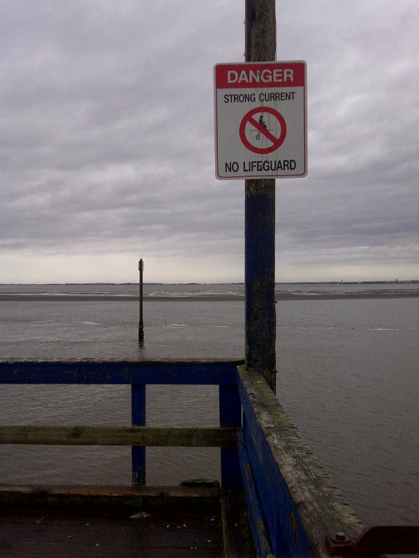 (see picture) and a series of pilings out in the water, marking the safe travel passage for boats in/out of the marina around the east side of Blackie Spit. Nautical traffic can make safe passage through tidal channels as the faster current prevents sediment from depositing and creating unsafe conditions for boats.
While on the pier, face inland, and observe the beach to the north and south of you, looking for man-made structures.
One method of combating longshore drift is the construction of groynes. The orientation of a groyne is vital to it's effectiveness, and a careful observation of the direction the sand is piled up against the groyne is a clue to the prevailing direction that longshore drift is moving sediment.
In order to log this EarthCache:
- go to each of the two waypoints/coordinates
- I encourage you to take a photo of yourself and/or your GPS at one or more of the coordinates, but this is optional
- answer the following questions about Blackie Spit and the Crescent Beach area, and email the responses to the CO (please do not post your answers in your log entry)
Question #1 - Where did the beach material which formed Blackie Spit originate from (what is the prevailing direction of the tidal current)?
Question #2 - How do the groynes combat longshore drift?
Question #3 - What can you observe about the deposition of sand along the groynes to the north and south of the pier, and how does that relate to the formation of Blackie Spit?

Additional Hints
(No hints available.)
Treasures
You'll collect a digital Treasure from one of these collections when you find and log this geocache:

Loading Treasures