Slip Face & The Disappearing Maritime Forest
This Earth Cache brings you to Run Hill Dune in Nags Head Woods near Kill Devil Hills, North Carolina. Run Hill Dune and Nags Head Woods are owned by the Nature Conservancy which maintains preservation efforts. The Wright Brother’s first powered flight occurred on the north end of Run Hill Dune in 1903. Though no longer connected to Run Hill Dune thanks to development, you will be able to view the monument from this location. Nags Head Woods will eventually be covered completely by the Run Hill Dune.
The purpose of this Earth Cache is to monitor the rate at which the dune is overtaking the maritime forest by observing a geologic progression of the dune’s Slip Face.
How are dunes formed? Sand dunes require each of the following: (1) a steady wind, (2) a ready supply of sand and (3) an obstacle such as vegetation, rocks, or fences which trap the sand. Sand dunes form when moving air slows down on the downwind side of an obstacle. The sand grains drop from the wind and form a mound that becomes a dune.
Run Hill Dune is an unusually large, unconstrained, natural dune. The dune was formed by winds from the two prevailing directions on the Outer Banks, the northeast and southwest. Because the two prevailing winds flow in opposing directions, tremendous volumes of sand accumulate, and the opposing flow contributes to form steep slopes on the northeast and southwest sides of the dune.

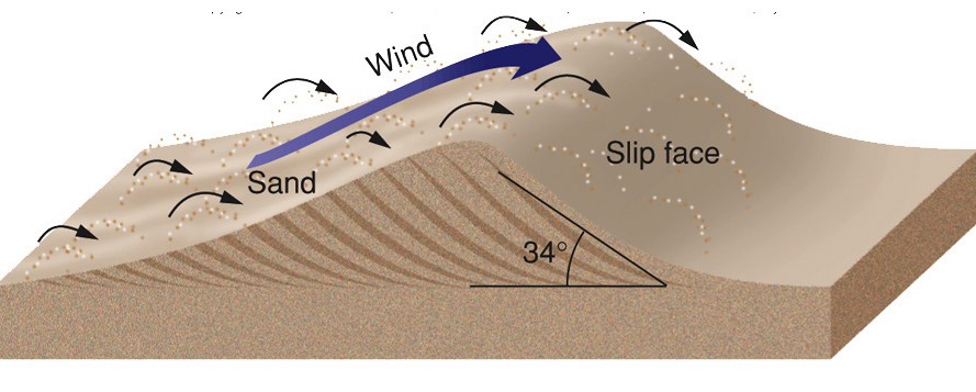
What is a Slip Face? The slope on the leeward or downwind side of a dune is referred to as a Slip Face. Dunes migrate by erosion when sand from the upwind slope is deposited on the downwind or leeward slope. Avalanches often result due to the steep drop in elevation and unstable sediment present once the prevailing winds have eased. The migration of a dune is always in the direction of the slip face. Slip face sediment is smooth on the surface, not rippled. A Slip Face consists of loose, cascading sand that generally follows the slope at the Angle of Repose (approximately 34 degrees for dry sand). The Angle of Repose is the maximum slope at which sediments remain stable.
Wind erosion control: Several techniques are useful in controlling wind erosion. They include installing wind fences, providing natural materials to act as wind fences, planting vegetation and using earth moving machines.
To claim this Earth Cache answer to the following by email. Please don’t post in your log.
1. What is the distance from ground zero to the Slip Face Angle of Repose--where the slip face begins ascending at least at a 34 degree angle? You will see an obvious elevation increase.
2. What is the height of the Slip Face? This is easily done by measuring the elevation at the top of the slip face and subtracting the elevation at the bottom.
3. Toward what direction is the Slip Face moving?
4. Based on your observations and using the above information as a guideline, did you notice any effort being made to control erosion at this location? If so describe what you saw.
5. From this Earth Cache you will be able to see the Wright Brothers Memorial to the north. The memorial sits atop a dune once connected with Run Hill Dune. It is protected from wind erosion by what method mentioned above?
6- Optional, post a photo of you and/or your group near the Slip Face...making a funny “face” if you like