NOTE: There is no physical geocache here. Please refer to the different geocache types on the website before posting!!!
Haynes Point Provincial Park
Osoyoos Lake is an 8.76 km^2 lake almost split in two by a sandbar on which the town of the same name is built. Osoyoos Lake is the warmest lake in Canada according to the town and BC Parks boasting an average summer temperature of 24°C (75°F). Where did Haynes Point, this one kilometer long bar come from?
Could the material have come from a nearby river or creek?
The answer is no. It will be left up to you to explain why this is not a possibility. There are at least three reasons why this theory can be disproved.
What is a Kettle Lake?
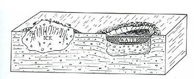
A kettle lake is formed when a glacier, a giant sheet of ice up to several kilometers thick, melts and leaves behind large chunks of ice as the glacier breaks up. Depending on the climate, it can take quite a while for these large chunks of ice to finally disappear and in the meantime, water flows around them carrying rocks, silt, and sand. When the ice finally melts altogether, a depression remains and fills with water. Kettle Lakes such as these can be seen all over the Okanagan-Similkameen.However this lake is no puddle like the others, but an international body of water and an integral part of the Okanagan River System providing domestic water to thousands.
Where Did Haynes Point Come From?
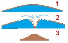
Glaciers are not just pure ice, but more like dirty ice cubes which contain a significant amount of debris. It is believed that a large ice chunk melted and a crevasse opened up in the middle and the chunk broke up further. As the ice melted, torrents of water carried substantial amounts of rocks, cobbles, and boulders down into this crack. Since the crack was narrow and long, the debris piled up over a narrow, long region and contained mostly large rocks. Finally the ice melted altogether and Osoyoos Lake is what remained.
It can be compared to a stencil or when you fold a piece of paper to put glitter down on paper in an organized fashion.
To Log This Cache
Send an E-mail to my geocaching profile answering the following question(s). Feel free to log before hearing an answer from me but if an answer is not received in a reasonable amount of time, Earthcache guidelines require me to delete your log.
1.) How do you know that this sandbar was not created by rivers or streams flowing into Osoyoos Lake? There are three reasons why this can't be so.
2.) What are the ranges of sizes of cobbles and pebbles found at GZ. Stay away from campsites, roads, and picnic areas as gravel as trucked in from the Lakeview-Dividend Mine west of Osoyoos!
References
Roed, M. & Fulton, R. (2011). Okanagan geology south : geologic highlights of the South Okanagan Valley, British Columbia. Kelowna, BC: Okanagan Geology Committee.
