Wacissa River:
The Wacissa River is a large, spring-fed stream located in south-central Jefferson County, Florida. Its headwaters are located about a mile south of the town of Wacissa, where the river emerges crystal clear from a group of large limestone springs. From its headsprings, the river flows approximately 12 miles (19 km) south through a broad cypress swamp before breaking into numerous braided channels which join the Aucilla River a few miles further south. The river is part of the Aucilla Wildlife Management Area, and has been declared an Outstanding Florida Waterway by the Florida Department of Environmental Protection.

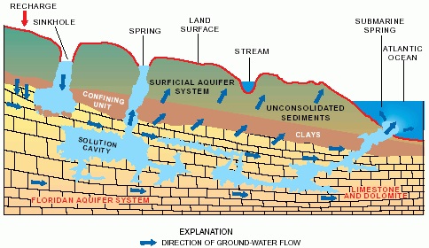
What are springs?
Springs are natural openings in the ground through which water beneath the surface discharges into hydrologic features such as rivers. Big BlueSpring has one main vent nearly 6 ft (1.8 m) in diameter at the bottom of the circular spring pool. Maximum depth of pool is 42 ft (12.8 m). The water is light greenish blue with large suspended particles, and the bottom is barely visible. Big Blue Spring is formed from an opening in the water aquifer. An aquifer is any layer of rock, sand, or other material through which water can flow. Big Blue Spring is a natural breach in a clay layer that separates the surface sands of the surficial aquifer system from the limestone and dolomite rocks of the Floridan aquifer system. The principal features of a spring system include an upland area where rainfall seeps into the surficial aquifer system. There also must be sinkholes or gaps in the clay layer where water can flow downward into the Floridan aquifer system. Inter-connected solution cavities and cracks in the rocks of the Floridan aquifer system conduct large quantities of water to the spring vent.
Most of the water discharging from Big Blue Spring is from rain that falls on the land area within the springshed. Ground water that discharges from the spring is a mixture of water from different parts of the springshed and of various ages.
The temperature of spring water discharging from the Floridan aquifer system is nearly constant. Geologic material is a good insulator, and rocks and sediments buffer changes in the temperature of ground water that might result from recent rains. Big Blue Spring averages 70° F year round.
The Wacissa River is well known for its large concentration of aquatic birds, including egrets, herons, ibis, osprey, wood storks, limpkins, anhingas, kingfishers, barred owls and bald eagles. Aquatic animals are also abundant, including alligators, river otters, turtles, water snakes, and crayfish. The main species of fish are bass, mullet, catfish, red-breasted sunfish, stumpknocker and gar, although the warmouth perch, speckled perch, flier bream, and shellcracker may also found in the Wacissa.
Prior to logging this cache, email the answers to the following:
- What is the diameter of the spring pool (estimated)?
- Is the spring discharging with enough force to “boil” the surface of the water?
- Sometimes green algae is present due to high nitrate content, was it present during your visit?
- What man made item is located on the southwest side of the pool?
- Optional: Post photos of your visit with your log.
Sources: www.flsprings.com; www.usgs.gov