Hurricane Creek Weir Dam EarthCache
-
Difficulty:
-

-
Terrain:
-

Size:  (other)
Please note Use of geocaching.com services is subject to the terms and conditions
in our disclaimer.
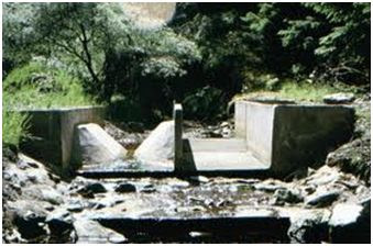
Hurricane Creek originates in northern Johnson Country near Main St in Greenwood. It continues to flow into the Province Park in Franklin, where it merges with Young’s Creek just after a weir dam. What is the purpose of the weir dam before the merger?
A weir dam is a small overflow-type dam that is used to raise the level of a river or stream. Weir dams have historically been used to create mill ponds but have also been used to control erosion. Water flows over the top of a weir. Since the weir is the portion where water is overflowing, a long weir allows a lot more water with a small increase in overflow depth. This is done in order to minimize fluctuation in the depth of the river upstream with changes in the flow rate of the river. Weir dams also give hydrologists and engineers a simple method of measuring the rate of flow over the weir and check oxygen levels of the water.
They can be used to reduce the flow rate of the water, which will reduce the effect of erosion. One of the first problems with dams is the erosion of surrounding land and banks. Dams will hold back the sediment load normally found in a river flow, depriving the downstream of this. In order to make up for the sediments that are trapped by the dam, the downstream water will start to erode its channels and banks. This lowering of the riverbed will threaten vegetation and river wildlife as well.
One of the reasons dams are built is to prevent flooding. However, most ecosystems which experience flooding are adapted to this and many animal species depend on the floods for various lifecycle stages, such as reproduction and hatching. They rely on the floods to strive. Annual floods also deposit nutrients and replenish wetlands.
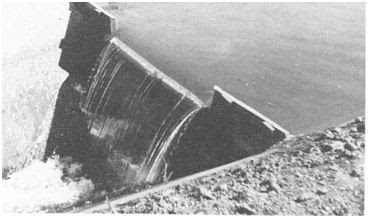
Sharp Crested Weir
A sharp-crested weir allows the water to fall cleanly away from the weir. Sharp crested weirs are typically thin metal plates or concrete.
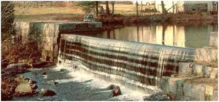
Broad Crested Weir
Broad crested weirs are large structures that are generally constructed from reinforced concrete and which usually span the full width of the river or stream.
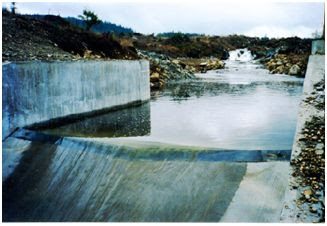
Crump Weir
A Crump weir is a fixed weir dam with water flowing over it and usually it has a trapezoidal shape while being made out of concrete.
V-notch weir
This is a specially shaped weir in which the flow through the weir is directly proportional to the head.
Combination Weir
For accurate flow measurement over a wider range of flow rates, a combination weir combines 2 or more types of weirs. Below a V-Notch weir with a crump weir
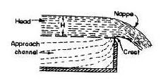
There are several terms associated with weir dams.
Nappe - the flow or discharge after the crest.
Head - the level above the crest
Crest - the width of the top of the weir
Approach - the level of the river below crest
To get credit for this cache, send the following answers to my account:
1 What type of weir dam is this?
2 What is the approximate width (thickness) in inches of the crest? Not side of creek to opposite side of creek
3. What is the approximate drop in feet from the crest to the creek below?
4. Do you notice any sediment deposits in the pooling area?
5. Compare the characteristics of Hurricane Creek before and after the dam. Does the erosion seem better or worse after the dam?
6. Post a picture of yourself (face not required) or a personal item with the pond created by the dam in the background.
Additional Hints
(No hints available.)