KET #1: Journey to the Sea Traditional Cache
KET #1: Journey to the Sea
-
Difficulty:
-

-
Terrain:
-

Size:  (small)
Please note Use of geocaching.com services is subject to the terms and conditions
in our disclaimer.
Back Story:
We (kailua.cat&matt) attempted to do this trail back in 2010 but ran into a “Dark Cloud” and got completely lost. This was BC (before caching) and before we had a GPSr. We bushwhacked through strawberry guava trees, crossed gulches and streams, climbed cliffs, leaped over a wall in a single bound…wait, maybe not the last one, but we ended up at a Scouts Camp. We thought we had luckily hiked back to the Boy Scouts Camp where we had parked our car, but it was not to be. It was dusk and getting dark fast by the time we found out we were at the Girl Scouts Camp, which is on a completely different ridgeline at the top of COMSAT Road. By the good graces of a Girl Scouts caretaker and a Starbuck’s employee we got safely back to our car which was still parked at the top of Pupukea Road.
Years later, we decided to tackle this trail again after hearing that several members of the Hawaiian Trail and Mountain Club (HTMC) including, Stuart Ball, had successfully hiked and marked the trail. We were now armed with a GPSr and in the company of another experienced cacher, CelticGuardian, who assisted with all the cache placements. The trail was well groomed compared to when we first attempted it several years ago making our experience a pleasant hike. A huge mahalo to CG for your assistance with all the caches and for putting up with a Dark Cloud on what turned out to be a very beautiful day!
The Kaunala to ‘Ehukai Trail (KET)
The 6-mile long (one way) Kaunala-‘Ehukai Trail is located in the Pupukea-Paumalu State Park. This trail is maintained by HTMC and is open to the public. You can approach this trail either from the top or bottom, however, the waypoints and directions provided in this description will guide you along the KET from the Kaunala trailhead to the Sunset Beach Neighborhood Park. It is highly recommended that you take this route as you will have a pleasant downhill journey along the KET. Both parking and upper and lower trailheads are marked as waypoints.
The lower trailhead is located at Sunset Beach Neighborhood Park which is a public park located in front of Sunset Beach Elementary School. The lower trailhead is located just to the left before the metal gate leading into the school. PLEASE DO NOT PARK INSIDE THE SCHOOL. The school gate is locked during non-school hours.
The upper trailhead for the KET branches off from the main Kaunala Trail Loop which has a sanctioned trailhead located at the Boy Scouts Camp at the top of Pupukea Road. To find the upper trailhead for the KET, travel about 100 yards from the Kaunala trailhead sign. You will see the KET branching off to your left.
If you plan to do the entire 6 mile KET trail, it is recommended that you take two cars and park one car at the bottom at Sunset Beach Neighborhood Park and then drive your other car to the top of Pupukea Road and begin your journey from there.
The Six caches in the Kaunala to ‘Ehukai Trail Series:
- KET #1: Journey to the Sea
- KET #2: Whistling Pine
- KET #3: Power Outage
- KET #4: Onward Cacher!
- KET #5: ET Pupukea
- KET #6: Pill Box View III
CAUTION:
There are well over 22 miles of hiking and biking trails tangled in the Pupukea-Paumalu State Park area. Please be aware that the special sets of candy-cane-striped ribbons marking the KET are distinct at both ends of the trail but sparse in the middle. You will see sets of pink and other orange colored ribbons that dart off in all kinds of directions to designate different mountain biking and hunting trails. Throw in some jeep roads and metal placards into the mix and you can easily get disoriented while you are on the trail. If you are traveling the recommended route and beginning at the upper trailhead and heading down towards Sunset Beach Neighborhood Park, please maintain an overall mountain to ocean direction and pay attention to topography. We tied new orange ribbons, planted the “KET” caches along the way and posted some key waypoints to help guide your way. Happy caching!!
By the way, the caches in this series vary in sizes – please BYOP!
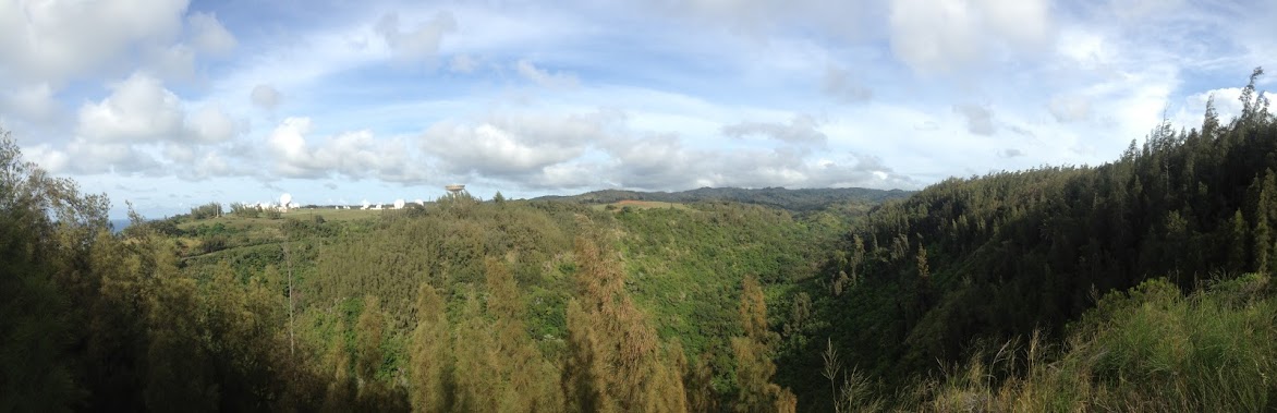
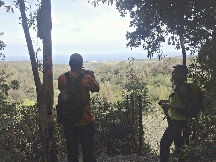 Your view before your descent
KET #1: Journey to the Sea
Once you have found the upper trailhead for the KET, you will proceed in a NNW direction. This part of the trail is marked with candy-cane-striped ribbons and will take you through a large grove of paper bark trees. This section of the trail has a gradual descent. However once you arrive at GZ, you will notice that the trail takes a steep dip down into the valley, thus marking your journey to the sea! From the cache area you will have a view of the large satellite dishes at the Inmarsat Broadband Global Area Network Satellite Access Station in the far off distance. You will have close-up view of these infrastructures as you near KET #5 in this series. This cache should be an easy find before your steep descent and journey to the sea.
Congratulations to Marcas_Found for being the first cacher to BIKE the entire KET series!!
Additional Hints
(Decrypt)
Snyyra gerr, pbirerq ol onex