WaStatePks100: Rainbow Falls Traditional Cache
WaStatePks100: Rainbow Falls
Related Web Page
Please note Use of geocaching.com services is subject to the terms and conditions
in our disclaimer.
This cache was originally placed in 2013 as part of the Washington State Parks Centennial GeoTour - "100 caches in 100 parks to celebrate 100 years" - cosponsored by Washington State Geocaching Association (WSGA).
Rainbow Falls State Park is a 139-acre camping and nature trail park with 3,400 feet of freshwater shoreline on the Chehalis River. Situated in stands of old-growth forest and bisected by SR 6, the scenic highway leads to Raymond and South Bend on Willapa Bay.
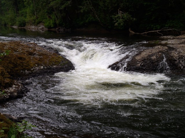
The land for this park was set aside in the early 1900's by the communities of Dryad, Doty and Pe Ell. Around 1920, the north side of the park across the Chehalis was cleared for camping and picnicking. Later the Kiwanis Club initiated a land exchange, allowing the state to acquire the section of old growth on the south side of the highway and set it up as Rainbow Falls State Park.
In 1935, The Civilian Conservation Corps (C.C.C.) built the ranger's home which is still in use. All bridges entering the park from the highway, including a suspension bridge built by the C.C.C., washed out during the great flood of 2007. Access to the park is now available on the north side along Leudinghaus Rd.
Park hours/updates:
Summer: 6:30 a.m. to dusk.
Winter: 8 a.m. to dusk.
The park is open year round for camping and day use.
Camping: Check-in time, 2:30 p.m.
Check-out time, 1 p.m.
Quiet hours: 10 p.m. to 6:30 a.m.
Driving Instructions: (Decided to add since all the nearby bridges crossing the Chehalis washed out in '07). A new steel bridge (2017) is now in place two miles east of Chandler Rd.
1. Take Exit 77 (I-5)
2) Route 6 west for 17 - 18 miles and look for Park signs onto Chandler Rd
3) Turn onto Chandler for .25 miles
4) Turn right onto Leudinghaus Rd. for 1 mile
5) Turn into new park entrance per coordinates on the right
** A new bridge has been built 2 miles east of Chandler. Use New Steel Bridge waypoint coordinates to save a few miles
If you have not already done so, be sure to stop by WaStatePks100: Willapa Hills Trail about three miles to the east.
|
- This geocache has an approved Permit to be placed at this location on property managed by the Washington State Parks and Recreation Commission. Visitors are responsible for acquainting themselves with policies and rules pertaining to State Parks areas.
- The following items may not be placed in the geocache: food, illegal substances, medications, personal hygiene products, pornographic materials, hazardous materials, or weapons of any type.
- By searching for the cache, visitors agree that they are responsible for their own actions, and acknowledge that neither the State of Washington nor the cache owner is responsible for any loss or injury that may occur in relation to such search.
- Report any incident, problem, or violation to State Parks staff.
|
Additional Hints
(Decrypt)
[05/17/20 - Cache site upgraded. Please keep up on hints.]
1) Genvy ragenapr ba gur rqtr bs gur bcra svryq orlbaq erfgebbzf
2) Gura qbja n fubeg fbpvny genvy ba gur evtug.
3) Ebyy hc lbhe fyrnirf naq yvsg.
4) Cyrnfr gel naq qvfthvfr pnpur nern naq fubeg ragenapr nf gubhtu ab uhzna unf ivfvgrq
*******************
Treasures
You'll collect a digital Treasure from one of these collections when you find and log this geocache:

Loading Treasures