 |
dqcjm5j906xj
|
|
Geohashing
|
Geohashing is a geo-location based activity in which "Every day, effectively random locations are generated by an algorithm". People then visit these coordinates, or try to. As they are randomly generated, they could be anywhere and accessing them can be relatively easy to impossible. Geohashing coordinates are generated by The Algorithm below which first appeared in an xkcd comic:
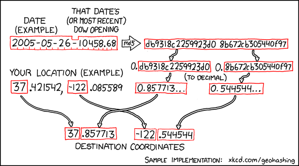
For example, on the date this cache was placed, the destination latitude and longitude would have calculated to --.977793 and ---.806943
There are a few Geohashing based challenge caches which I find interesting, and if you do a little searching ... you may even find a puzzle or two based on the concept.
Update (4/31/2014): Important note regarding “The Algorithm” if you are trying to manually calculate or duplicate it. When converting from hexadecimal to decimal, it is important to do so as a fraction as noted on the geohashing wiki. Each half of the 32 hexadecimal MD5 result should be prepended with a decimal point before conversion. Not doing so will result in a very different answer. Also, some eagle-eyed geocachers have noticed that in the sample provided, manually calculating the longitude would appear to result in --.544543 instead of ---.544544. I concur. Not sure why it’s shown as is.
You can check your answers for this puzzle on GeoChecker.com or certitude. Or, feel free to send any questions or coordinate confirmation to me via my profile if so inclined.
Final coordinates are in a park open dawn to dusk only. Do not attempt this cache at night!
For more information about Arlington park guidelines, including geocache placements, please refer to the Arlington County Park Rules & Regulations.

 |
Nominee:
Best Mystery/Puzzle Cache
|