John Muir attempted to preserve the lake and surrounding area that fanned the fire of his zeal and love for all nature. He went on to become the most rugged, fervent naturalist America has produced.
Muir was the first president of the Sierra Club and is considered the founding father of the modern conservation movement and the national parks of our country. He was also an early champion of the glacial theory that was just developing in the mid-1800’s while he was living here.

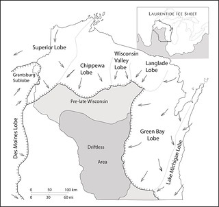
/>Reprinted by permission of Wisconsin Geological and Natural history Survey (WGNHS)
The Earth’s glacial period began about 2 million years ago with great temperature fluctuations. Periods of global cooling followed by interglacial periods of global warming. Each climate cycle lasted about 100,000 years. During the cooling periods, enormous ice sheets formed and spread across much of northern North America. Variations in topography and snowfall caused the massive ice sheets to move across the land at an uneven pace.
The Wisconsin Glaciation began about 25,000 years ago and ended about 10,000 years ago. It reached it greatest extent, covering approximately two-thirds of the state about 14,000-16,000 years ago. The advancing ice was also channeled into the lowland now occupied by Lakes Superior and Michigan, Green Bay, and the Fox River. It was impeded by the uplands of the Bayfield, Keweenaw, and Door Peninsulas. This channeling and impediment split the glacier into six major lobes as it flowed across Wisconsin.
As the glacial ice advanced, hills and bluffs were often sheared off right down to bedrock. As the glacier melted and retreated, debris suspended within the ice was deposited, filling depressions and leaving undrained, rolling lands. There are a variety of geological landforms associated almost exclusively with the work of glaciers that are probably better seen in Wisconsin than anywhere in the world.
Marquette County was entirely covered by the Green Bay lobe of the Wisconsin stage of glaciation. Ennis Lake is a kettle in pitted outwash. A kettle is a surface depression formed by large, detached blocks of melting ice that were buried with sand and gravel. An outwash plain is formed when glacial meltwater streams in front of glaciers. Other nearby glacial features include drumlins which are elongated, teardrop-shaped hills sculpted in the direction of the glacial ice; and erratics which are boulders carried long distances by the glacier and deposited when it melted.
 IATCC is the cache designation to highlight a series of EarthCaches along the Ice Age National Scenic Trail grouped into a special category called "ColdCache."
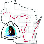
The Ice Age Trail is one of eleven National Scenic Trails designated by the National Park Service. This unique trail is entirely within the state of Wisconsin and follows along the terminal moraine of the most recent glacier which retreated about 10,000 years ago.
This project is supported by the Ice Age Trail Alliance (IATA). The goal is to bring more visitors to the trail and promote public awareness, appreciation, and understanding of Wisconsin’s glacial landscape.
The IATA has created an awards program to encourage visits to the trail and ColdCache sites. This awards program is separate from, and in addition to, any other Geo- or EarthCache awards program.
A current list of approved ColdCache sites can be found on the “IATCC Bookmark List”. More information on the Ice Age Trail Atlas, the Companion Guide, the ColdCache Project and Awards Program can be found on the “ColdCache Webpage”
Resources:
Geology of the Ice Age National Scenic Trail; by David M. Mickelson, Louis J. Mahler Jr., and Susan L. Simpson
John Muir Memorial Park – State Natural Area website: (http://www.tn.buffalo.wi.gov/community/muirpark.asp)
National Park Service; U.S. Department of the Interior Ice Age Trail Map
The Geocache Notification Form has been submitted to Patrick E Kilbey of the Marquette County Parks Department.
1. You will cross three footbridges as you walk around the lake; briefly describe the type of wetland you are crossing at each; (eg: stream, marsh, bog, etc.).
2. Imagine exploring the surrounding area as a child. What indications do you see that would indicate a 1.5 mile thick sheet of ice once covered the area?