What is a Tuya?
Subglacial volcanoes are called tuyas, a distinctive type of flat-topped, steep-sided volcano formed when lava erupts through a thick glacier or ice sheet. Tuya volcanoes are relatively rare phenomena, mostly found in regions which were covered by glaciers and had active volcanism during the same period, such as British Columbia, Iceland, Oregon and under the Antarctic ice sheets.
Just 26 miles north of where you are standing, also in the Cascade Range, is a classic tuya volcano named Hayrick Butte. This textbook example of a tuya was formed when its eruptions could not penetrate the overlying ice sheet, thus creating a flat-topped butte. The steep sides formed because the molten lava was trapped by the surrounding ice, which also cooled the lava quickly, thus solidifying the steep sides.
Other characteristics of a tuya volcano:
Columnar joints – formed by rapid cooling of the lava at the ice (water) interface.
Hyaloclastite – black, glassy material resulting from rapid quenching of liquid lava by melted ice.
Pillow lava – formed when water (melted glacial ice) quickly cools the lava; similar to shapes found on underwater volcanoes.
In the photo below, compare flat-topped Hayrick Butte (classic tuya) on the right with Hoodoo Butte on the left, a typical rounded (scoria or strombolian) cinder cone which erupted perhaps thousands of years after Hayrick and definitely after the ice sheet had completely melted away.
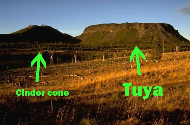
Photo by Lee Siebert, 1995 (Smithsonian Institution)
Back to our current location . . .
Years ago, this entire area also was iced over by glaciers. Then Talapus and Katsuk Buttes began to erupt beneath the ice sheet. Although this sounds like the beginning of two tuya volcanoes, Talapus and Katsuk Buttes both formed into everyday, typical cinder cones that sit atop a peculiarly steep-sided plateau.
This underlying steep-sided plateau DOES display many characteristics of having erupted against glacier ice. But, for whatever reason, perhaps the ice sheet was thin and the lava boiled away the ice, the buttes on top of the plateau do not display the same tuya-like characteristics.
Therefore, we appear to have a tuya plateau topped by two non-tuya cinder cones. The interpretive sign will further explain.
Logging this Earthcache
Please email or message the cache owner with answers to the following questions:
1. How many years ago was this area covered by a glacier?
2. What is the name of the yellowish-brown rock and soil deposits across the highway from where you are standing?
3. Why are tuyas more rare than typical, rounded-shape cinder cones?
Photos are welcome, but not required.
Once you have sent your answers, feel free to log your find immediately - you do not need to wait for a response. Please do not post the answers to the questions within your log. Thank you!
References
Smithsonian Institution National Museum of Natural History Global Volcanism Program, http://www.volcano.si.edu/galleries.cfm?p=6
Scott, W.E. and Gardner, C.A., 1990, Field trip guide to the central Oregon High Cascades: Oregon Geology, v. 52, no. 5, p. 108.
Cashman, K.V., Deligne, N.I., Gannett, M.W., Grant, G.E., and Jefferson, A., 2009, Fire and water: Volcanology, geomorphology, and hydrogeology of the Cascade Range, central Oregon: Geological Society of America Field Guide 15, p. 560.
Scott, W.E., Gardner, C. ., and Sarna-Wojcicki, A.M., (eds.), 1989, Field Trip to the Central Oregon High Cascades: U.S. Geological Survey Open-File Report 89-645, p. 6.
Digplanet, http://www.digplanet.com/wiki/Tuya
Digplanet, http://www.digplanet.com/wiki/Subglacial_volcano