Salmon Glacier Terminus View EarthCache
Salmon Glacier Terminus View
-
Difficulty:
-

-
Terrain:
-

Size:  (not chosen)
Related Web Page
Please note Use of geocaching.com services is subject to the terms and conditions
in our disclaimer.
About “Salmon Glacier Terminus View”:
Salmon Glacier Terminus View is a car-accessible EarthCache with a bump in difficulty due to the off-the-beaten-path nature of the location.
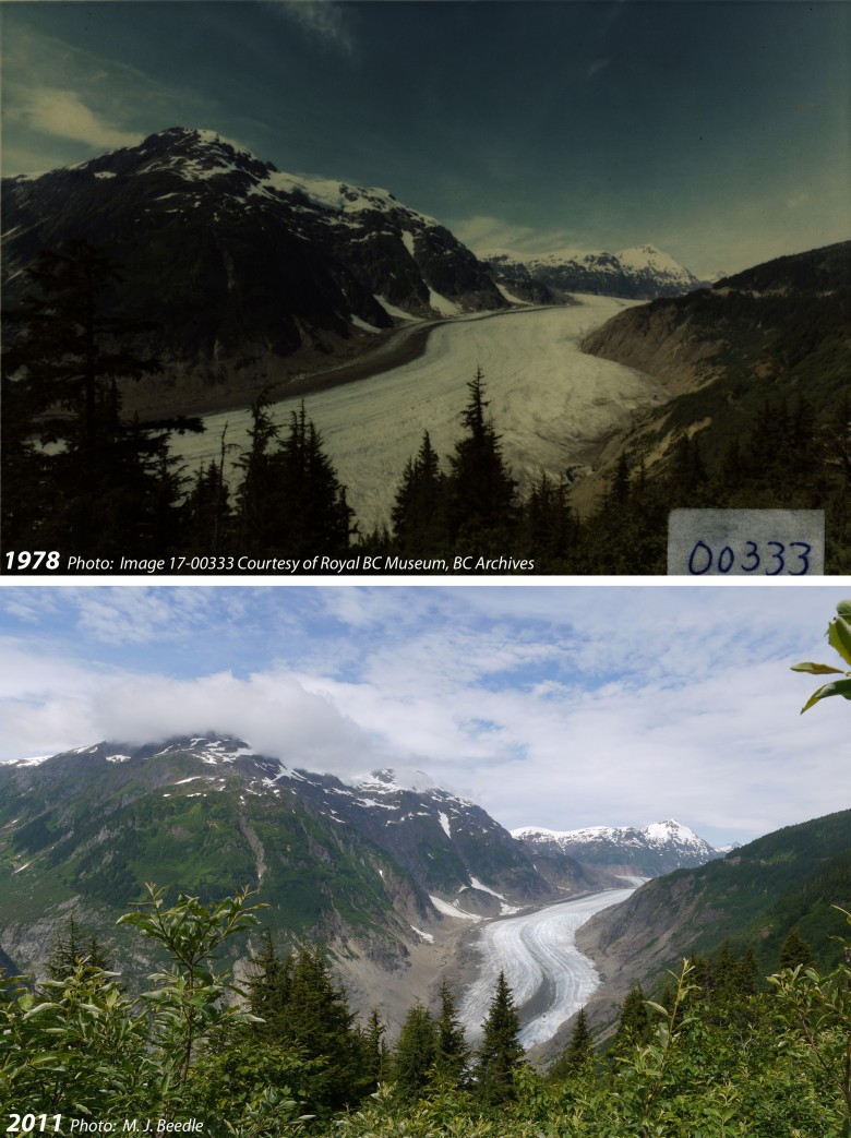
Stand in the same location where historic glacier photographs have been taken and compare them with what you see!
“Salmon Glacier Terminus View” About the General Location:
There is a long history of mining in northwestern British Columbia, and with it follows a legacy of work near, on, and even under the region’s phenomenal glaciers. It is this mining infrastructure (the Granduc Road specifically) that enables a relatively easy visit to this stunning location. In fact, we at GlacierChange.org are unaware of any similar locations in North America where it is possible to overlook such a massive glacier. We are excited that you are at this amazing location and encourage you to enjoy and explore the landscape around you, and invite you to contribute to the record of repeat glacier photography from this location.
Historical Image of Salmon Glacier:
NOTE: Please consider bringing a hard-copy version of the 1978 and 2011 images with you to “Salmon Glacier Terminus View” as this will provide the opportunity to see what the view looked like previously from the exact location where you will be standing!

Photo:
Image 17-00333 used by GlacierChange.org with the permission of the Royal BC Museum, BC Archives
This 1978 photo was taken from the location of this EarthCache. Compare this image to what you see today. What has changed since 1978? What other than the glacier has changed? What remains unchanged? Has Salmon Glacier changed since 2011?
Repeat photography:
Repeat photography is used in many scientific fields to document and quantify landscape change. Glacier repeat photography provides a powerful visual of dramatic landscape change.
Please consider taking a repeat photo from this location and helping GlacierChange.org document our changing glaciers.
When taking a repeat photograph take care to include all of the common features that you see in the previous images: mountain peaks and ridgelines (if it’s a clear day), trees etc. Depending on vegetation growth you may need to move away from the cache a bit to see the glacier.
If you do take a repeat image please upload it when ‘logging’ this geocache, and also consider submitting the image to GlacierChange.org (connect@glacierchange.org) along with the date and time you took the image.
About Salmon Glacier:
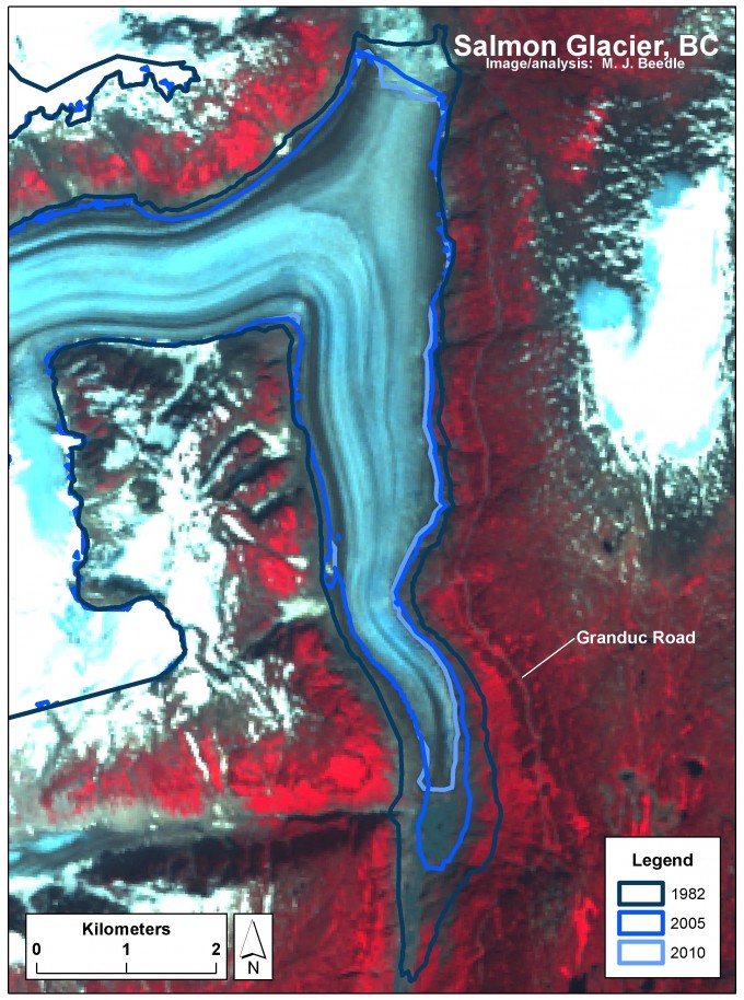
Salmon Glacier has an area of 77 km2 (as of 2010). Only about one third of this area is visible from the Granduc Road. Salmon Glacier is unique in many ways, but one of its most dramatic features is an ice-dammed lake (Summit Lake) that forms annually. This lake (to the immediate left of the title “Salmon Glacier, BC” in the image at left) actually drains under the ice to the south, emptying into the Salmon River.

Requirements for logging this EarthCache:
Please include answers to the following questions:
1. How many people are in your group?
2. Has the terminus of Salmon Glacier thinned or thickened since 1978? Estimate in meters (1 m = 3.28 ft) how much thinning or thickening has occurred at the present day terminus of Salmon Glacier since 1978. If you don’t have the 1978 photo with you the former elevation of the glacier is marked by the trim line – the line separating bare rock below and vegetation above.
3. Glaciers lose most of their mass through melt at the surface. Surface melt is caused by many factors, but a primary cause is temperature. Warmer temperatures equal more melt.
With time the surface elevation of a glacier changes as it thins or thickens. And with this change in elevation also comes a change in air temperature at the surface. Changes in air temperature as you go up or down in the atmosphere (known as the lapse rate) are highly variable, but average about 0.6°C for every 100 meters – warmer (+) as you go down, and cooler (-) as you go up. As a glacier thins, the surface temperature changes, which in turn results in more melt, further thinning, higher temperatures, more melt . . . in a self-reinforcing loop (known as positive feedback). In glaciers, this positive feedback mechanism at the surface is known as elevation feedback, altitude mass balance feedback, or the Bodvarsson effect.
Due to the Bodvarsson effect has air temperature at the surface of Salmon Glacier increased or decreased since 1978?
Estimate by how much air temperature at the surface of Salmon Glacier has increased or decreased due to the Bodvarsson effect.
To do so multiply the average lapse rate (0.6°C/ 100 m) by your estimate of thinning or thickening in question #2 – remember the lapse rate is positive (+) in the case of thinning or negative (-) in the case of thickening:
0.6°C / 100 m * #2 Answer
Example, if the terminus of Salmon Glacier thickened by 400 m since 1978:
-0.6°C / 100 m * 400 m = -2.4°C
Thank you for visiting Salmon Glacier Terminus View!
For more information on Salmon Glacier, glacier change, and glaciers in general please visit GlacierChange.org.
Best wishes and happy adventures!
Additional Hints
(No hints available.)