LE VILLAGE DE GRIMAUD
PETITE HISTOIRE DE GRIMAUD
Le village de Grimaud témoigne d'une longue histoire, commencée dés l'époque gallo-romaine. Au XIe siècle, son piton escarpé attira l'attention des stratèges. Point haut, dominant le Golfe de Saint-Tropez et contrôlant les accès depuis le nord et le massif des Maures, il connut donc une occupation défensive précoce. Jusqu'au XVIIe siècle, le château de Grimaud commandait le Golfe qui s'est appelé d'ailleurs "golfe de Grimaud" jusqu'à la fin du XIXe siècle.
L’EGLISE ST MICHEL
L'église telle qu'elle s'offre à nous aujourd'hui date du second âge roman provençal (fin XIIe - début XIIIe siècle). Le gros œuvre en granit ainsi que les éléments en calcaire (corniches, arcs doubleaux et porte en plein cintre) sont appareillés avec soin.
L'épaisseur des murs, l'abside et les absidioles en cul-de-four intégrées dans des massifs rectangulaires donnent au bâtiment une certaine robustesse, gage de sa longévité. Cette solidité permit au XVIe siècle la construction du clocher sur une partie de la voûte sans mettre en péril l'édifice. Les deux cloches datent de 1786 et 1866 et pèsent respectivement 528 et 730 kilos.
Sur la façade sud se trouve le cadran solaire et une phrase en provençal signifiant : "Ton lever je le vois au soleil mais ne sais pas si je verrai ton coucher".
A l'intérieur, le décor (XIXe siècle) représente Saint Michel terrassant un dragon entouré de Saint Pierre et Saint Barthélémy.
Antérieurement, les murs étaient recouverts d'un enduit de couleur ocre et peut-être entièrement ornés d'un décor peint comme on peut encore en apercevoir quelques vestiges.
Au XVIIIe siècle, la sacristie fut bâtie en annexant le fond de l'absidiole nord.
L'église Saint-Michel est classée Monument Historique.
LE CHATEAU
Les premières mentions du château et de son village apparaissent au XIe siècle dans les chartes de l'abbaye Saint-Victor de Marseille : Castri nomine Grimaldi et Grimaldo castello. Les fortifications se résument certainement à une simple palissade et quelques murs en pierres sèches. Durant les XIIe et XIIIe siècles, les Comtes de Provence sont les suzerains du Freinet territoire couvrant les actuels cantons de Grimaud (et Saint-Tropez).
Le village se trouve aux abords du château. Les maisons appuyées contre la colline sont en partie taillées dans le rocher, comme les silos à grains. A la fin du XIIIe et début du XIVe siècle, une plus grande insécurité de la région exige une meilleure protection du village et du château. Le rempart tel qu’il existe encore aujourd’hui est donc construit. Pour cela, quelques maisons du village se trouvant sur son tracé sont détruites.
Au XIVe siècle, la famille Adorne est propriétaire du château.
Au XVe siècle, la famille Cossa se trouve à la tête de la seigneurie. Les besoins en eau potable entraînent la reconversion de la salle du rez-de-chaussée de l’ancienne tour en citerne (85m3).
Par ailleurs, les habitations situées dans l'enceinte des remparts sont progressivement abandonnées, les villageois s’installant à l’extérieur.
La famille De Vesq règne sur la seigneurie au XVIe siècle, il semble que le château n’est occupé que par intermittence et donc peu entretenu.
La famille Castellane rachète la seigneurie et règne sur le territoire durant les XVIIe et XVIIIe siècle. Le château est agrandi, les deux tours rondes aux cordons de serpentine (roche métamorphique vert sombre) sont construites. Les habitations intra muros sont complètement désertées, le village acquiert sa physionomie actuelle.
À la Révolution Française, le seigneur Jean-Baptiste de Castellane part en exil à Nice. Le château est abandonné. Déclaré « carrière de pierre », il tombe en ruine. Les encadrements des fenêtres en serpentines sont pillés.
Témoin de l’histoire du village, le château est classé monument historique depuis 1928.
HISTORY OF GRIMAUD
The village of Grimaud reflects a long history, which began soon the Gallo-Roman era. In the eleventh century, its rocky outcrop attracted the attention of policymakers. High Point, overlooking the Gulf of St Tropez and controlling access from the north and the Massif des Maures, so he knew early defensive occupation. Until the seventeenth century, the castle of Grimaud commanded the Gulf which is called also "Gulf of Grimaud" until the end of the nineteenth century.
THE CHURCH
Today’s church dates from the second Roman-Provençal period (end of the 12th – beginning of the 13th Century); the granite fabric and the limestone elements (cornice, arches and doors) were made with care.
The thickness of the walls, the apse and apsidal chapel give to the building a kind of robustness, guarantee for its long life. This solidity allowed in the 16th Century the construction of the bell tower on part of the vault without disturbing the building. The two bells date from 1786 and 1866 and weigh 528 and 730 kg.
On the southern façade we find the sundial and a sentence in Provençal language which means “Your rising, I see it with the sun, but I do not know if I will see your lying down
The interior: a fresco painting (19th Century) represents St Michael with St Peter and St Bartholomew
The sacristy was built in the 18th Century, using the back of the northern apsidal chapel.
St Michael’s Church, a listed historical building
THE CASTLE
The first mentions of the castle and the village appear in the 11th Century in a title of the St Victor’s Abbey of Marseille: Castri nomine Grimaldi and Grimaldo Castello. The fortifications consisted most certainly of a simple palisade and some stone walls. During the 12th and 13th Centuries the Counts of Provence were the suzerains of the Freinet(nowadays districts of Grimaud and St Tropez). The village was located in the outskirts of the castle. Some of the houses were built directly into the rock, as the grain silos.
At the end of the 13th and beginning of the 14th Centuries a more important insecurity in the region required a better protection of the village and the castle. The present rampart was built for this reason and some village houses located on its line had to be destroyed.
At the 14th Century the family Adorne was owner of the castle. Little by little the inhabitants abandoned the use of the grain silos built into the rock and used earthenware jars to stock food.
In the 15th Century the family Cossa took over the ownership of the castle. The need of water required the conversion of the ground floor of the ancient tower into a cistern (85 m3). The present opening is from the beginning of the 20th Century. The houses located within the circle of the rampart were gradually abandoned; the people of the village settled down in the outskirts
The family De Vesq was at the head of the seigneury in the16th Century; it seems that the castle was occupied only sporadically at that time and, consequently, it was very little maintained.
The family Castellane bought the seigneury and ruled the territory during the 17th and 18th Centuries. The castle was enlarged, the two towers with the serpentine (metamorphic dark green rock) cordons were built. The habitations intra muros were completely abandoned, and the village got its present appearance.
At the French Revolution the seigneur Jean Baptiste de Castellane went into exile at Nice. The castle was abandoned; it fell into ruin; the serpentine frames of the windows were stolen.
The castle is a listed monument since 1928.
ENIGME / ENIGMA
|
Aller à / go to :
N 43°16,523
E 006°31,360
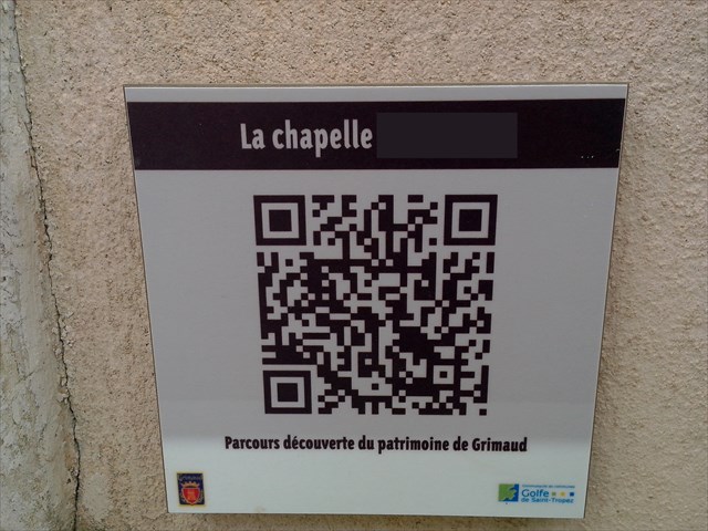
B = le nombre de lettres du nom de la chapelle (sans le tiret)
B= the number of letters of the name of the chapel (without "-")
|
Aller à / go to :
N 43°16,440
E 006°31,356
E= le chiffre des centaines
E= the hundreds
 |
Aller à / go to :
N 43°16,434
E 006°31,306
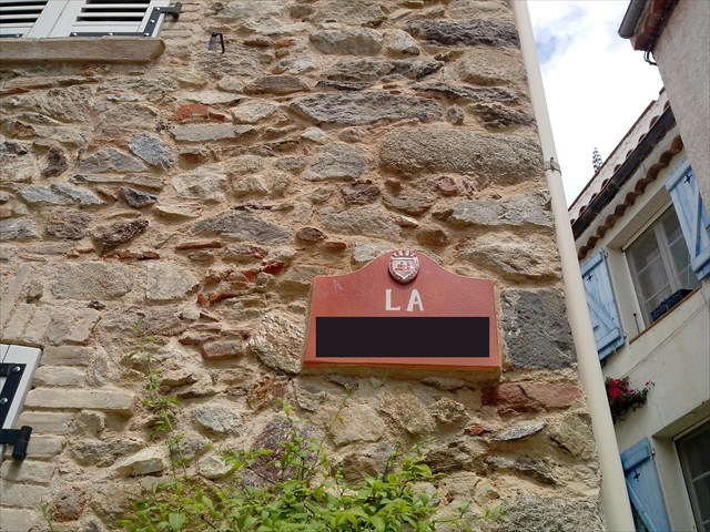
A = le nombre de lettres du nom de la place - 4
A= the number of letters of the name of the place - 4
|
|
Aller à / go to :
N 43°16,426
E 006°31,250
F= le numéro
F= the number

|
Aller à / go to :
N 43°16,422
E 006°31,121
C= le chiffre des dizaines - 1
C= the tens - 1

|
Aller à / go to :
N 43°16,449
E 006°31,306
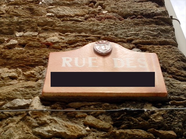
D= le nombre de lettres du nom de cette rue - 6
D= the number of letters of the name of this street - 6
 |
|
LA CACHE / THE CACHE
N43°16,ABC
E006°31,DEF
|