WARNINGS:
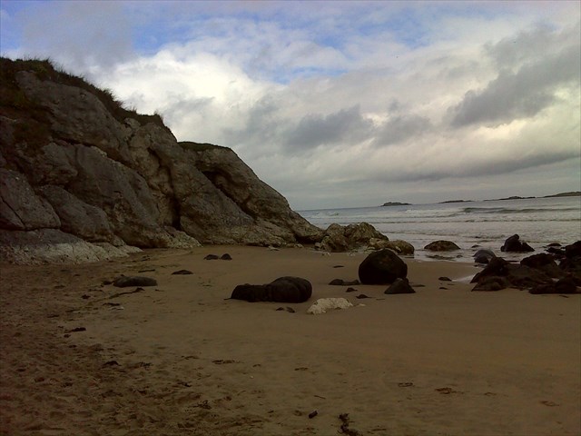
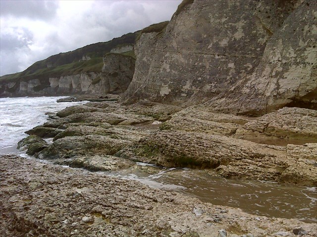
- THE EARTHCACHE AREA CAN BE CUT OFF BY THE TIDE – IF YOU ARE CUT OFF THERE IS A ROUGH PATH OVER THE ROCKS AT THE REAR OF THE LARGE ROCK OUTCROP (which is the 1
st place that the tide will cut you off – see picture & ESCAPE waypoint). Buggies will need to be lifted & small kids/disabled may need a some help to cross this way. It is a terrain 4/4.5 rating for around 20m. Please only use this route if you cannot walk along the beach. We use 2 android mobile phone apps for tide information (both free) ‘UK Tides’ & ‘Irish Tide Levels’ (other apps & websites are available)
DO NOT TAKE RISKS WITH THE TIDE – YOU MAY BE CUT OFF COMPLETELY!
- CHILDREN SHOULD BE SUPERVISED AT ALL TIMES. THIS IS A DANGEROUS LOCATION.
- DOGS are permitted on this area of the beach but there are restrictions on the main beach at certain times of the year.
- DO NOT be tempted to climb on the cliff faces as they are very dangerous.
The White Rocks
The White Rocks is an Area of Special Scientific Interest. Please bear this in mind as you enjoy this Earthcache and do not remove rocks from any of the cliff faces or damage any flora in the area. Ideally "Leave no Trace" www.lnt.org
The "White Rocks" is the name given to cliffs to the east of Portrush in County Antrim, Northern Ireland. These cliffs are made of chalk, or Ulster White Limestone. Chalk is a pure form of limestone and, in the case of the White Rocks, was laid down on beds of Hibernian Greensand between 142 and 65 million years old during the Cretaceous period. Tiny single celled photosynthesising algae called coccolithophores thrived in a warm shallow sea that covered this area. Over time their calcareous skeletons, known as coccoliths, built up on the sea floor and were compressed to form the chalk we can see here today. Courses of flint run through the chalk.
The Cretaceous chalk can be seen in many parts of North East Ireland; it has survived in such good condition because it is capped by basalt which erupted from fissures in the earth's crust that opened as North America and Europe separated about 65 million years ago forming the Atlantic Ocean.
About 120 metres of chalk can be found in the north coast of County Antrim today although not all in one place — where local erosion or a lack of deposition ocurred, some levels within the chalk will be absent. The thickness beneath the basalt 'cap' is not known although the Aughrimderg Borehole gave a result of 150 metres, however this may be a result of faulting, which might have repeated some of the rock sequences.
The chalk rocks are rich in fossils; if you look carefully you may see some. Some of the flints are preserved and perfectly formed echinoids which were siliar to modern sea urchins. There are also belemnites of various kinds. These cigar-shaped fossils are the remains of the internal skeletons of octopus-like creatures, the soft parts of which have not been preserved.
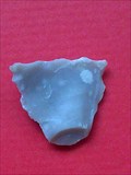
Early people used the flint to make weapons and other tools. In the picture you can see our attempt at flint knapping an arrowhead. 'Flint knapping' is the name given to the process of chipping the flint into the required shape using a 'hammer stone' which needs to be harder than the flint being napped or it will break up during the hammering. Phil Harding of Time Team fame is a renowned flint knapper.
Many sites with worked flints have been excavated, especially the coast of County Antrim. Perhaps it was the flint that first attracted Mesolithic people to Ireland some 8000 years ago - their first known habitation was in Mountsandal close to Coleraine and not far from the flint from which they made their tools.
In the last century the chalk was burned in kilns to produce quicklime for spreading on fields. This reduced the acidity of the soil and did much to improve the productivity of agriculture. The remains of these kilns are still dotted about, close to chalk outcrops and you can see one further along the coast at Ballintoy Harbour where there are a few more geocaches. Nowadays chalk mined in Glenarm, in the Glens of Antrim, is used for a wide range of industrial purposes - including acting as a constituent in toothpaste and in the white lines painted on roads all over Europe.
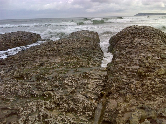
Common features of a chalk/limestone coast are sea stacks and sea arches. You can see sea stacks at this earthcache.
SEA STACK DEFINITION
A sea stack is an isolated pinnacle of rock that is surrounded by the sea at high tide.
SEA STACK FORMATION
Sea cliffs around our coast receive a constant onslaught from various erosion processes e.g. wind, water etc. The most important is Hydraulic Wave Action, which in simple terms is the process of waves hitting the rocks at incredible pressures and literally `exploding` in the joints and crevasses. Softer rock is exploited at a faster rate than harder rock and eventually the cliff will fall away unevenly to form headlands and bays.
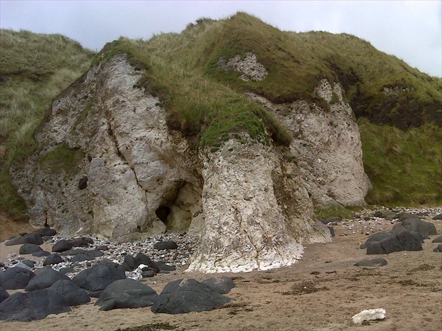 Waves will continue to batter the headlands from both sides and in softer rock, and particularly where there is a vertical crack (or fracture), a sea cave will form with a single opening. The opening will continue to be exploited until the cave opens all the way through to form an arch. You can see caves forming in the cliffs at the White Rocks (see photo above).
Even with the formation of the arch the erosion processes do not stop. The waves continue to widen the gap until the rock above can no longer be supported. At this point the top portion collapses into the sea below. This leaves the furthest arch support standing out in the open sea as a SEA STACK.
Interestingly if a sea stack’s summit diameter is greater than the stack’s height it is officially an island!
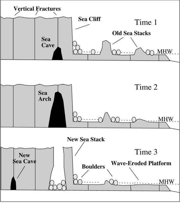
Information on sea stack formation & drawings reproduced by kind permission of geocacher Snake Plissken
When the tide is out you can also see part of the wave eroded platform and the cracks that run through limestone are very apparent as points of weakness for erosion; the sea has is continuing to open the fissures and this can be clearly seen if the waves are at the edge of the rocks when the wave continues along the length of the fissures.
You will also notice that the rocks are angled. This probably happened when the mantle (the liquid core under the earths crust) settled after the ice caps retreated at the end of the last ice age - if you imagine sitting on a waterbed; the water underneath moves away when your weight is added then flows back when you get up. This happened here only much, much more slowly.
There was probably a sea stack here a very long time ago.
Logging the cache
To log your visit to the Earthcache you must answer the following question & e-mail your answers to me (via my profile name at the top of this page). Either Metric or Imperial measurement unit is acceptable.
Do not put your answers or spoilers photographs on the `logged it` page. Any spoiler logs will be deleted.
a. There are 3 stacks of reducing height in a row. Estimate the height of the tallest of the 3 sea stacks.
b. Is the smallest of the 3 a sea stack or an island?
c. to the left of the 3 stacks (with your back to the sea) there is a chalk cliff face with clearly defined flint layers
i) how many layers are there, &
ii) what is notable about make up of the layers?
d. (optional extra) You will see lots of broken rocks lying around on the ground. Some of these are chalk and some are flint. Look at these carefully...can you see any fossils? There are also lots of broken flint rocks on the ground...is there one that could be used as a tool? Imagine you lived in the Stone Age; what do you think it would be best used for? Be careful as the flint shards can be very sharp. DO NOT remove rocks or fossils from the cliff faces. Please do not take any rocks away from the site. Take a photo of your fossil / flint tool and post it on your log, with yourself included, if you wish. Take care not to accidently include spoiler information with your photo.
You can log your find but you also must e-mail your answers to me (via my profile page). I will do my best to either confirm your completion of the Earthcache or get back to you with any queries within 48 hours. If you have not heard from me with in 72 hours of forwarding your answer please feel free to send me another e-mail.
If you are on holiday and there will be a delay in forwarding the answers please leave a message with you 'found it' log if you can.
Unfortunately, if I don't receive the answers from you I will delete your log.
